
( 🇦🇱 --> ⬇️ )
This Earthcache takes you to a beautiful valley in the southwest of Albania. But how do these special landscapes emerge, which offer a unique habitat for flora and fauna?
"Sculptor of all these landscapes is the cycle of water. So strong as no other force, water sooner or later forms the earth's surface. Wherever water flows off in small streams or large rivers, a valley forms. This is due to the fact that flowing water digs deeper and deeper into the ground. The soil on the sides slides down towards the riverbed. A slope forms to the right and left of the watercourse, creating a valley along the river. Valleys can look very different: Steep walls or gentle slopes, wide valley bottoms or just enough space for the river. The shape depends on how strongly the water attacks the ground and the side walls and how resistant the rock is."[1]
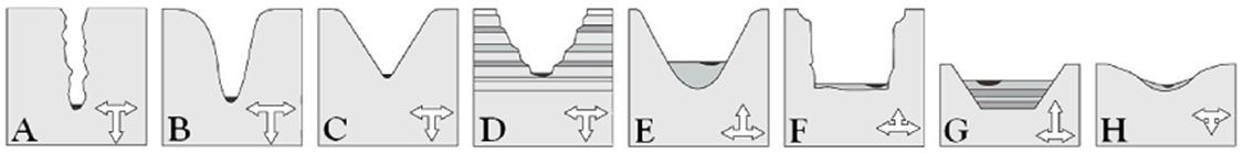
Valleys are created by the interplay of depth erosion and width erosion:
Depending on how strong the various types of erosion work, there develop different valley shapes, which are illustrated by the following graphics:
 [3]
[3]
"Towards the estuary, the river becomes wider and carries more and more water. Because the terrain becomes flatter, the water flows more and more slowly. For this reason, the river gradually deposits its cargo back on the ground at the lower reaches. Removal takes place rather on the side walls, so that rather wide, flat valleys are formed." [1]
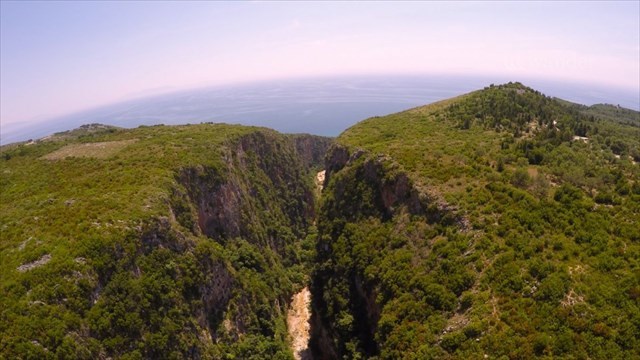
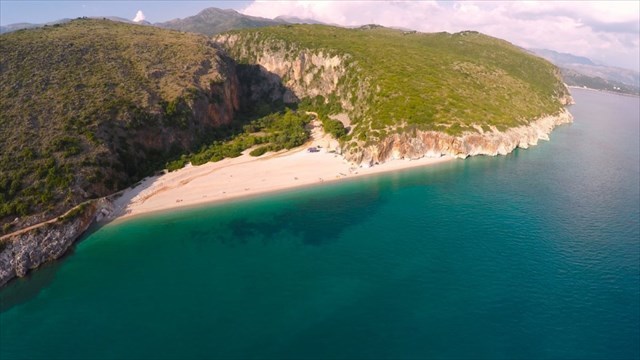
Canyon of Gjipe
 [4]
[4]
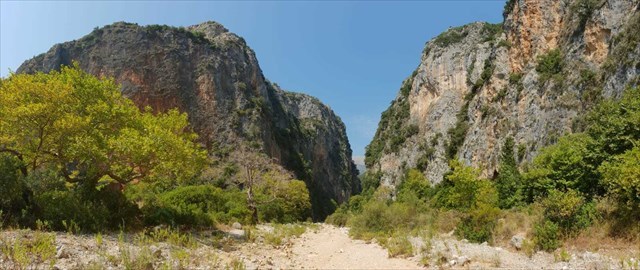
"Canyons are a special form of valleys. Here the water has dug its way through different layers of rock, which lie like several layers of cake on top of each other. Some layers were easily eroded by the river, they were washed out broadly and roundly, the more resistant layers broke off steeply and angularly. The result is a valley whose side walls descend like steps towards the river. A famous example of such a valley is the Grand Canyon in the US state of Arizona." [1]
 [4]
[4]
Unfortunately, the beach of Gjipe is no longer an insider tip, but because of the quite long and exhausting way to the bay (unless you come over the Sissi-way with the motorboat  ) the number of tourists is still limited. The adjacent canyon of Gjipe is in any case still a worth recommendation. The deeper you walk into the canyon the more you are alone and can enjoy the fantastic landscape. For a hiking tour in the canyon you should have a high level of sportiness, as you have to climb sometimes and the stony to rocky path can be very slippery in wet conditions. Sometimes the use of slings and climbing ropes can be advisable... but you don't have to climb for fulfilling the tasks of this earthcache.
There are several ways to explore this beautiful piece of nature.
► On the one hand there is a scenic hiking trail which starts at station 1 (N40°08.408 E019°40.570) and ends at the mouth of Gjipe Canyon, directly at the beach of Gjipe. Along the trail you will find signposts for small detours away from the main trail, leading you to several recently installed viewing platforms. These offer spectacular views into this incredible coastal canyon, as well as towards the ionian see to which it opens. The route is about 3km long. Once you reach the beach, you can enjoy a swim in the sea or explore the base of the canyon. The canyon walls are also suitable for rock climbing and have some existing routes with bolts in place. Other activities at the beach include kayaking and the exploration of the nearby so-called Pirates' Cave.
► Furthermore you can find a possible parking place at the coordinates given in the waypoints of this cache (N40°07.822 E019°39.512). From there you have to follow a rather rocky path over a distance of 1.5km, which can be quite exhausting at temperatures well over 30 degrees. If you drive an off-road vehicle, you can drive directly into the bay. Here you have the possibility to pitch your tent directly at the beach or at the adjacent camping site and spend the night in the idyllic Gjipe Bay. There are also now two small restaurants on the beach and for a small fee you can also rent umbrellas.
Once you've cooled down in the crystal clear water, pack enough drinking water and explore a little bit the wonderful canyon and log the cache by the way
IF YOU WANT TO LOG THIS CACHE, SEND YOUR ANSWERS TO THE FOLLOWING QUESTIONS AT THIS E-MAIL ADDRESS:
friedl-at-gjipe@gmx.net
After you have sent your answers, feel free to log immediately. If anything is wrong, we will contact you.
Go to station 1 (N40°08.408 E019°40.570). There you will find a sign to the gorge. Use this sign to find the answers to the following questions:
1. What is the length, the width and the maximum height of the canyon of Gjipe? (don't trust the internet!)
2. As described in the text above, water formed this landscape. From which mountains comes the stream that formed this canyon?
3. The signpost tells you: " The name of Gjipe Canyon is supposedly derived from the Greek language, based on the word for "falcon"." Explain briefly the context of the name with the physical structure of the canyon.
Go to one of the viewpoints along the scenic hiking trail above the canyon which starts at station 1 (N40°08.408 E019°40.570) or to Station 2 (N40°07.607 E019°40.236) to the beach of Gjipe at the mouth of the canyon and answer questions 4. and 5. based on what you see when you look at the canyon:
4. Explain briefly how the Canyon of Gjipe was created. Which of the erosion explained in the listing mainly shaped the gorge (depth erosion or width erosion)?
5. Which of the valley forms (A - H) shown above are found in this valley?
optional:
6. Optionally take a picture of you (your GPS or anything else... be creativ ;) ) in the canyon, along the trail above the canyon (starting at N40°08.408 E019°40.570) or on the beach at Station 2 (N40°07.607 E019°40.236).
!!! Hiking or climbing in the canyon requires a high level of physical fitness and, if necessary, the use of personal protective equipment (helmet, sturdy footwear, slings or climbing ropes,...). Everyone decides for themselves what they are capable of and how far they can go. The owners of this cache are not liable for your actions and their consequences! Everybody is responsible for himself! Do not enter the canyon alone and take enough drinks with you.
--- To log this cache, nobody has to be in danger and does not have to enter the canyon or even climb in the canyon!! ---
The focus is solely on having fun with our shared hobby and enjoying the fantastic landscape! In this sense... have fun and enjoy the time !!!
!!! AND OF COURSE YOU TAKE ALL YOUR GARBAGE BACK WITH YOU!!!
----------------------------------------------------------------------

Në qoftë se ju doni të hyni në këtë cache, dërgoni përgjigjet tuaja për pyetjet e mëposhtme në këtë adresë e-mail:
friedl-at-gjipe@gmx.net
Pasi ta keni dërguar përgjigjet tuaja, të ndjehen të lirë për të hyrë brënda menjëherë. Nëse diçka është e gabuar, ne do t'ju kontaktojmë.
Shkojnë në stacionin 1 (N40 ° 08.408 E019 ° 40.570). Aty do të gjeni një shenjë të grykës. Përdoreni këtë shenjë për të gjetur përgjigje për pyetjet e mëposhtme:
1. Çfarë është gjatësia, gjerësia dhe lartësia maksimale e kanionit të Gjipesë? (Nuk i besojnë internetin!)
2. Siç është përshkruar në tekstin e mësipërme, uji formuar këtë peizazh. Nga të cilat male vjen lumë që ka formuar këtë kanion?
3. Shtyllë drejtuese e ju tregon se: "Emri i Gjipe Canyon është me sa duket rrjedh nga gjuha greke, bazuar në fjalën për "Falcon"." Shpjegoni shkurtimisht kontekstin e emrit me strukturën fizike të kanionit.
Shko në një prej pikëpamjeve përgjatë gjurmët skenik hiking mbi kanion i cili fillon në stacionin 1 (N40°08.408 E019°40.570), ose në stacionin 2 (N40°07.607 E019°40.236) deri në plazhin e Gjipesë në grykën e kanionit dhe pyetje përgjigje 4. dhe 5. bazuar në atë që ju shikoni kur ju shikoni në kanion:
4. Shpjegoni shkurtimisht se si u krijua Kanioni i Gjipe. Cila nga erozioni i shpjeguar në renditje kryesisht ka formuar grykën (erozionin e thellësisë ose erozionin e gjerësisë?
5. Cila nga format e luginës (A - H) e paraqitura më lart janë gjetur në këtë luginë?
fakultativ:
6. Opsionale marrë një pamje të ju (GPS tuaj ose ndonjë gjë tjetër ... të jetë Creativ) në kanion, përgjatë gjurmët mbi kanion (duke filluar në N40°08.408 E019°40.570) ose në plazh në Stacionin 2 (N40°07.607 E019°40.236).
!!! Hiking ose ngjitje në kanion kërkon një nivel të lartë të palestër fizike dhe, nëse është e nevojshme, përdorimi i pajisjeve personale mbrojtëse (përkrenare, këpucë guximshëm, slings ose litarë ngjitje, ...). Gjithkush vendos për veten e tyre se çfarë ata janë të aftë dhe se sa larg mund të shkojnë. Pronarët e këtij cache nuk janë përgjegjës për veprimet tuaja dhe pasojat e tyre! Gjithkush është përgjegjës për veten e tij! Mos hyni në kanion i vetëm dhe për të marrë pije të mjaftueshme me ju.
--- Për log këtë cache, askush nuk duhet të jetë në rrezik dhe nuk ka për të hyrë në kanion apo edhe të rritet në kanion!! ---
Fokusi është vetëm mbi të kesh kënaqësi me hobi tonë të përbashkët dhe duke shijuar peizazhin fantastike! Në këtë kuptim ... të argëtohen dhe të gëzojnë kohën !!!
!!! Dhe sigurisht ju merrni të gjitha mbeturina tuaj përsëri me ju !!!
source disclosures:
[1] https://www.planet-schule.de/mm/die-erde/Barrierefrei/pages/Wie_entstehen_Taeler.html
[2] https://www.planet-wissen.de/natur/gebirge/schluchten/index.html
[3] https://www.spektrum.de/lexikon/geowissenschaften/talformen/16259
[4] https://de.wander.al/tours/enkelei-tour/2-activities-in-jal-and-gjipe
