|
Welcome to the geological series AGT. The Katskhi pillar is a natural limestone monolith located at the village of Katskhi in western Georgian region of Imereti, near the town of Chiatura. It is approximately 40 metres (130 ft) high, and overlooks the small river valley of Katskhura, a right affluent of the Q'virila.
კეთილი იყოს თქვენი მობრძანება გეოლოგიურ სერიაში AGT. კაცხის სვეტი ბუნებრივი კირქვის მონოლითია, რომელიც მდებარეობს იმერეთის დასავლეთ საქართველოს რაიონის სოფელ კაცხში, ქალაქ ჭიათურის მახლობლად. იგი დაახლოებით 40 მეტრია (130 ფუტი) სიმაღლეზე, და გადაჰყურებს კაცხურას პატარა მდინარის ველს, ხოლო ყვირილას მარჯვენა ნაპირს.
GEOLOGY
The rock tower is a natural geomorphological shape and a structurally denuding relief form. It is an isolated, tall and often slender column or prism, resembling a tower.
The rock tower is created as a result of mechanical erosion by gradual division and destruction of the plateau or rocky ridge. Its shape is the result of mechanical weathering and rock removal or slope settlement.
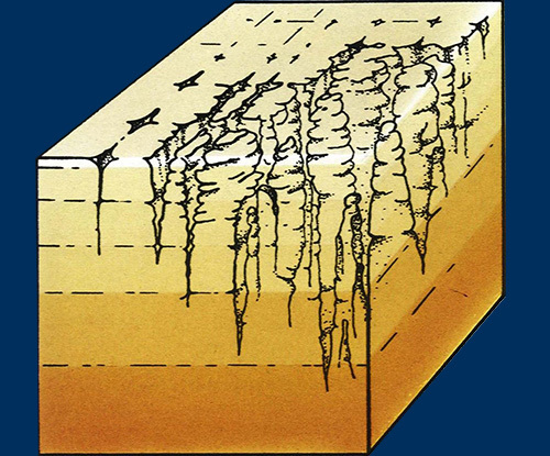
On the seashore, rock towers are formed by abrasion and isolation of the more resistant parts of the undermined and abraded coastal cabin (cliff).
გეოლოგია
კლდოვანი კოშკი ბუნებრივი გეომორფოლოგიური ფორმაა და სტრუქტურულად უარყოფითი რელიეფის ფორმაა. ეს არის იზოლირებული, სიმაღლის და ხშირად სუსტი სვეტი ან პრიზმი, რომელიც კოშკს წააგავს.
კლდოვანი კოშკი იქმნება მექანიკური ეროზიის შედეგად, პლატოზე ან კლდოვან ქედზე თანდათანობით დაყოფით და განადგურებით. მისი ფორმა არის მექანიკური ამინდის და კლდეების მოცილების ან ფერდობის დასახლების შედეგი. ზღვის სანაპიროზე კლდოვანი კოშკები წარმოიქმნება ჩაშლილი და აბრაზიული ზღვისპირა სალონის (კლდე) ზღვის მდგრადი ნაწილების აბრაზიით და იზოლირებით.
|
|
Limestone
Limestone is a carbonate sedimentary rock that is often composed of the skeletal fragments of marine organisms such as coral, foraminifera, and molluscs. Its major materials are the minerals calcite and aragonite, which are different crystal forms of calcium carbonate (CaCO3). A closely related rock is dolomite, which contains a high percentage of the mineral dolomite, CaMg(CO3)2. In old USGS publications, dolomite was referred to as magnesian limestone, a term now reserved for magnesium-deficient dolomites or magnesium-rich limestones.
კირქვა
კირქვა არის კარბონატული დანალექი კლდე, რომელსაც ხშირად შემადგენლობაში შედის საზღვაო ორგანიზმების ჩონჩხის ფრაგმენტები, როგორიცაა მარჯანი, ფორამინეფერა და მოლუსკები. მისი ძირითადი მასალებია კალციტი და არგონიტი მინერალები, რომლებიც კალციუმის კარბონატის სხვადასხვა ბროლის ფორმებია. მჭიდროდ დაკავშირებული ქვა არის დოლომიტი, რომელიც შეიცავს დოლომიტის მინერალის მაღალ პროცენტს. ძველ USGS პუბლიკაციებში დოლომიტი მოიხსენიებოდა, როგორც მაგნიუმის კირქვა, და ახლა დაცულია მაგნიუმის დეფიციტური დოლომიტებით ან მაგნიუმით მდიდარი კირქვებით.
Erosion
Erosion is a natural process of disruption and transport of objects on the Earth's surface (soil, rocks, rocks, etc.). The cause of erosion is the mechanical effect of moving surrounding substances - mainly wind, flowing or rippling water, ice, snow, moving weather and unpaved deposits. Erosion is not chemical dissolution of rocks (corrosion). Erosion has always been an existing natural process. Some degree of erosion as a natural phenomenon may be beneficial to ecosystems, but lately, erosion has been increasingly intensified by human activity, which is reflected in increasing soil depletion.
Erosion is caused by gravity due to other factors such as precipitation intensity, soil structure, slope slope, plant cover density, land use. It is proportional to the flowing mass m and velocity v (m.v² / 2). The rate of erosion is the amount or thickness of material transferred over a period of time. An important obstacle is the hardness of eroded rock, in softer it is larger, so it is a selective activity.
Rain is an important factor of erosion, but the intensity of erosion is dependent on the interaction of other factors. Vegetable cover prevents a higher degree of erosion, while deforested slopes or “salvaged” lands will be eroded more quickly. Soils containing larger amounts of clay minerals absorb less water and are less disturbed on a looser slope. Human activity is an important factor of the present. Soil erosion is increased by grazing grass, uncontrolled logging, dwelling and road construction. In particular, the construction of roads and railways disrupts the natural river network and water running down the road gets to places where it would not normally flow and thus increases the erosion that is causing it.
Similarly, changing the composition of the cover affects erosion, as different types of vegetation have a different effect at the rate of rain infiltration into the soil. The effect of deforestation or burning of tropical forests can be well observed in Madagascar, where erosion causes the formation of plateaus with agriculturally unusable land and numerous erosion gorges. Especially in economically poor areas, the interest in nature conservation and the possibility of livelihood of the population conflict. Furthermore, agriculture, which is based on the cultivation of plants in need of uncovered soil for cultivation (eg wheat), and the widespread use of the plow for cultivation of soil, leads to erosion.
ეროზია
ეროზია არის დედამიწის ზედაპირზე ობიექტების მოშლა და ტრანსპორტირების ბუნებრივი პროცესი (ნიადაგი, ქანები, კლდეები და ა.შ.). ეროზიის მიზეზია მიმდებარე ნივთიერებების გადაადგილების მექანიკური მოქმედება - ძირითადად ქარი, მიედინება ან დალევა წყალი, ყინული, თოვლი, მოძრავი ამინდი და გაუგონარი საბადოები. ეროზია არ არის კლდეების ქიმიური დაშლა (კოროზია). ეროზია ყოველთვის იყო არსებული ბუნებრივი პროცესი. ეროზიის გარკვეული ხარისხი, როგორც ბუნებრივი მოვლენა, შეიძლება მომგებიანი იყოს ეკოსისტემებისთვის, მაგრამ ბოლო დროს, ეროზია უფრო და უფრო გააქტიურდა ადამიანის საქმიანობით, რაც გამოიხატება ნიადაგის დაქვეითების გაზრდაში.
სიმძიმის გამო ეროზია გამოწვეულია სხვა ფაქტორებით, როგორიცაა ნალექების ინტენსივობა, ნიადაგის სტრუქტურა, ფერდობზე ფერდობზე, მცენარეთა საფარის სიმკვრივე, მიწის გამოყენება. ეს არის პროპორციული მიედინება მასა m და სიჩქარე. ეროზიის სიჩქარე არის მასალის გადაცემა დროის განმავლობაში. მნიშვნელოვანი დაბრკოლებაა აღმოფხვრილი კლდის სიმკვრივე, რბილში უფრო დიდია, ამიტომ შერჩევითი საქმიანობაა.
წვიმა ეროზიის მნიშვნელოვანი ფაქტორია, მაგრამ ეროზიის ინტენსივობა სხვა ფაქტორების ურთიერთდამოკიდებულებაზეა დამოკიდებული. ეროზიის მისაღებად მცენარეული საფარი, ხოლო ტყის ფერდობებზე ან "გადარჩენილ" მიწებზე უფრო სწრაფად ამოიშლება. ნიადაგები, რომლებიც უფრო დიდი რაოდენობით თიხის მინერალებს შეიცავს, ნაკლებ წყალს შთანთქავენ და ნაკლებად განიცდიან ფხვიერი ფერდობზე. ადამიანის საქმიანობა აწმყოს მნიშვნელოვანი ფაქტორია. ნიადაგის ეროზია იზრდება ძოვების ბალახით, უკონტროლო ხეებით, საცხოვრებლად და გზის მშენებლობით. კერძოდ, გზებისა და რკინიგზის მშენებლობა არღვევს ბუნებრივ მდინარეთა ქსელს და გზის გასწვრივ წყალი იღებს ადგილებს, სადაც ის ჩვეულებრივ არ შემოვა და ამით ზრდის ეროზიას, რაც იწვევს მას.
ანალოგიურად, საფარის კომპოზიციის შეცვლა გავლენას ახდენს ეროზიაზე, რადგან მცენარეულობის სხვადასხვა სახეობებს განსხვავებული ეფექტი აქვთ წვიმის შეღწევის სიჩქარით ნიადაგში. ტროპიკული ტყეების ტყეების განადგურების ან დაწვის ეფექტი კარგად შეიმჩნევა მადაგასკარში, სადაც ეროზია იწვევს სოფლის მეურნეობისათვის გამოუსადეგარ მიწასთან და მრავალი ეროზიის ხეობებით პლატოების წარმოქმნას. განსაკუთრებით ეკონომიკურად ღარიბ რაიონებში, ბუნების შენარჩუნებისადმი ინტერესი და მოსახლეობის კონფლიქტის შესაძლებლობა. ამასთან, სოფლის მეურნეობა, რომელიც დაფუძნებულია გაუთვალისწინებელი ნიადაგის გაშენებისთვის საჭირო მცენარეების გაშენებაზე (მაგ. ხორბალი), და გუთნის ფართოდ გამოყენება ნიადაგის გაშენებისთვის, იწვევს ეროზიას.
|