///paradise.equality.disco
The Family and I visited the Blue Lagoon again in August 2019 and I looked for an EarthCache here because it’s such an excellent (even bodacious) place – not finding one, it’s time to create my own!
 Earth Science Lesson
In the North Pembrokeshire Coastal area you can observe geological structures from three distinct groups of up to 650 million years old
Pre-Cambrian age GRANITES (older than 541 Million years ago) are IGNEOUS formed from high silicate magma intrusions that have risen through the crust and then cooled slowly underground to crystallize into granitic rock.
Cambrian age SANDSTONES (541 - 485.4 million years ago) are SEDIMENTARY rocks formed from sediment laid down, here by the sea waters which flowed over the volcanic landscape and contain the fossils of the many creatures who called that home.
Forming through the Lower Palaeozoic era (545 - 417 million years ago), SLATES are METAMORPHIC, made up of quartz and other minerals and were formed by pressure acting on an original SHALE-type sedimentary rock, itself composed of clay or volcanic ash. It contains parallel lines of cleavage that allow it to fracture into smooth, thin slabs, making it a useful stone for many applications.
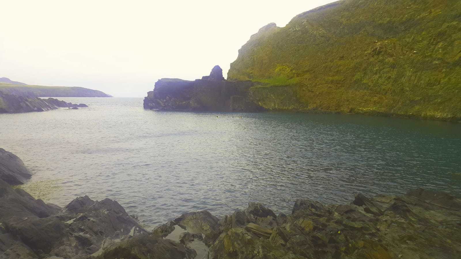
Abereiddi and the Blue Lagoon are a good example of the rocks from the Ordovician period (485.4 - 443.8 million years ago) and earlier:
- The headland that protects the North side of the lagoon is a hard granite
- The Blue Lagoon itself is principally slate and shale and the minerals from this give the water its distinctive colouration
- Abereiddi beach’s dark sand is comprised of broken mudstone rocks: dark grey slate and shingle. The beach, carpark and marsh behind are part of a channel created by meltwater after the last ice age and was moving steadily inland for 10,000 years until the sea defence was built in the 1960s.
- The old sea wall has been removed by Pembrokeshire County Council and a new shoreline is developing as the sea erodes part of the car park. A new sea defence of boulders is planned once a long term alignment of the shoreline has been reached. This illustrates a new approach linked to an expectation of climate change and sea level rise
Fossils can be found in the Ordovician shales, chunks of which fall from the cliffs and can be found wedged in below: as the site is an SSSI (Site of Special Scientific Interest) hammering the bedrock (including the cliffs) is strictly prohibited. All you really need to do is to walk along the beach and look at the soft, flaky shales for the graptolites for which the location is famous. Didymograptus murchisoni are the most common with gastropods, nautiloids, the brachiopod, and trilobites also found.

Didymograptus murchisoni
How the Blue Lagoon was formed
Geological processes alone are not responsible for this 25m deep tidal pool in a sheltered amphitheatre set with shining sapphire seawater.
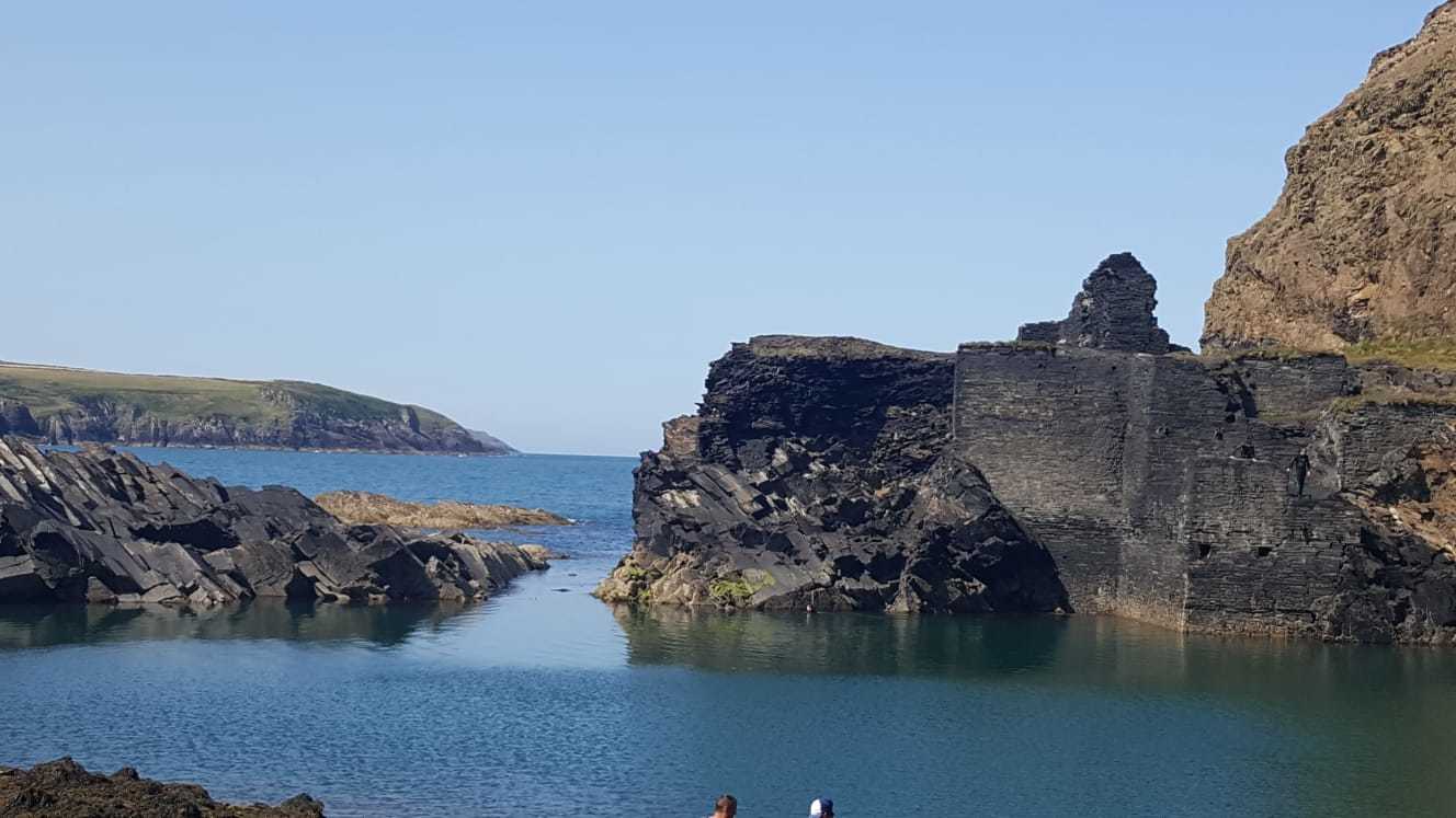
The lagoon used to be St Brides Slate Quarry (later Porthgain Slate Quarries) which was active up until 1910, before being abandoned and the channel connecting the quarry to the sea blasted, allowing the sea to flood in to form a sheltered haven for fishermen’s boats.
Pembrokeshire had a significant slate industry of around 100 quarries in the late 18th & most of the 19th century, with slate extracted initially exported across Abereiddi beach and later transported by a 2 mile long horse-drawn tramway to the Porthgain Harbour for export around the Bristol Channel and to the South of England.
The quarry opened in 1831 and was part of the Abereiddi Industrial Complex with products consumed in all parts of the British Isles, the wide demand being due to the attractive colouring of Pembrokeshire slates. The colours ranged from purple-black to blue, green, grey, silver-grey, and rich orange and brown. The quality was not all good and probably a high proportion of the slate was used for slabs and carved products such as troughs and cisterns as the slate is friable and not suited for roofing.
The quarry operated a steam-hauled lift and the ruins on the far side of the cliff housed the winding gear for hauling the slate from the bottom of the quarry. The remains of the tramway which took the slate from Abereiddi to the processing works in the harbour of Porthgain can be seen on the cliff top and the ruins of a group of 5 slate houses known as The Street remain near the beach. These were houses built for the quarry workers of the Blue Lagoon and were only abandoned in the 1930s after a typhoid epidemic and a severe storm. **Please don’t enter the ruins as this can cause structural damage**
The Blue Lagoon Today
An easy access path to the Blue Lagoon was installed in the late 1990s using funding from the European Union via the Pembrokeshire Coast National Park Authority. The site is looked after by The National Trust and is a Site of Special Scientific Interest.
Bordered by beautiful beaches and craggy rocks, the lagoon is world-class for watersports.
It’s a mecca for all sorts of adventure, including kayaking, diving, coasteering and wonderful walks and has become an international arena for the modern sport of cliff diving. The Red Bull Cliff Diving World Series visited the Blue Lagoon in 2012 (the first time the event had ever been held in the UK) and hosted the event again in 2013 and 2016.
I know from personal experience that the cliff diving is exhilarating but beware: the water is deep and cold – and the scuba divers on site told us later that the ‘sea bed’ there is populated by a risk of lobsters (Google tells me that’s the collective noun to use!). As the water in the lagoon is very deep and cold, it is strongly recommended that visitors wanting to cliff dive should be use a local activity provider that belongs to the Pembrokeshire Outdoor Charter and follows the Pembrokeshire Marine Code.
The Questions
- Between Abereiddi Bay and the Blue Lagoon there’s a strong new bridge: how many horizontal planks can you count beneath your feet (+/- 10% for counting errors – it took me 3 goes to be confident)
- Identify the type of rocks that make up a. the headland and b. the quarried rocks: classify them as sedimentary, igneous or metamorphic and which eras they might correspond to
-
Observe the structure of rocks remaining on the cliffs facing into the lagoon. Describe their structure: are they layered or irregular, if there are layers, how thick are they & at what angle, if irregular is the surface smooth, finely textured or roughly textured? Explain what uses do you think the quarried rocks would be put to why are they suitable for this based on your observations.
- Relate the current shape of the lagoon to the rock properties and the industry they engendered: speculate on the shape you would find here if humans had not intervened
- Optional: please take a picture of the lagoon from roughly the same spot I did and post it in your log – I’d love to see how the vista changes over the tides and seasons
I will accept answers via email or through the Message Centre. Please do not reveal the answers in your logs - any that do will be deleted without notice. I will only contact you if you have given the wrong answer.
How to get there
Address
Abereiddi: SA62 6DT, Abermawr: SA62 5UX
By cycle
National Cycle Network route 4 offers many stunning views between Haverfordwest, St David's and Fishguard. It stays close to the coastline, mostly on quiet lanes. It touches National Trust land at Abercastle and Abermawr Woods, but runs about ½ mile away from Abereiddi and Porthgain
By bus
Catch the Strumble Shuttle, 404 bus service, between St David's and Fishguard (also Newport in summer). It has regular stops along the coast, including Abereiddi, Porthgain, Abercastle, Mathry and Abermawr (½ mile from beach and woods). There are bus connections at St David's for Haverfordwest train station and Milford Haven
By train
Regular bus services into this area from Fishguard train station 10 miles. Haverfordwest train station 26 miles
By road
The A487 is the main access road to this area from Fishguard, St David's and Haverfordwest with minor roads heading out towards the coast. Abereiddi, Porthgain and Abercastle villages are sign-posted. The Car park at Abereiddi Beach charged £4 for the day when we used it.
On foot
The 186 mile Pembrokeshire Coast Path is Wales' only National Trail. It is a 12 mile walk along this stretch from Abereiddi to Abermawr, via Porthgain, Longhouse and Abercastle. St David's Head is about 6 miles along the coast path to the south west and Strumble Head is about 6 miles to the north east