On March this year, there is a mass archiving of caches within certain nature reserves and parks due to requests by the reserve managers. One of my favorite part about Geocaching is that it brings me out to very interesting places that I may not have the motivation to visit if not for the caches, so I thought that it is a pity that the caches had to be archived (although understandable). Luckily, virtual stages can still be set within these places. This multi-cache will bring you to five four different quarries within no-cache zones, and the cache itself is located outside the zones.
Geologically, the core of Singapore comprises a granite complex, called the Bukit Timah Granite. In more central parts of Singapore, including Bukit Batok and Bukit Timah, this granite was exposed during the last century by quarrying. Abandoned quarries collected rainwater, eventually forming these scenic lakes. The quarries in Bukit Gombak rest on the Gombak Norite, a geological formation that predates the Bukit Timah Granite and rests on it, but for more information on it you should visit the Earthcache there (which you can also go for if you haven't yet).
The quarries you need to visit for this cache are:
- Singapore Quarry
- Hindhede Quarry
- Poh Hin Quarry (the one in Bukit Batok Nature Park)
- Gammon Quarry (AKA Little Guilin)
Seng Chew Quarry
Dairy Farm Quarry is not included as it is filled up with earth and not opened to hikers anyway. There are also several other quarries nearby like Gali Batu Quarry and Lian Hup Quarry but I am pretty sure they are not opened to public.
You can visit the quarries in any order, but it is recommended that you visit the 3 in the east first. The cache is located close to Little Guilin and Seng Chew Quarry, so you should leave them for last. The total distance of this multi-cache is around 9km, but with how far the waypoints are, you can just take public transport between certain waypoints, making it much faster to complete. Still, you should bring along plenty of water. Two of the stages is only open from 7am to 7pm, so you should only do the cache in the day. The last 2 waypoints can also prove difficult if you visit them at night.
This multi-cache is a little tricker than usual, but still simple enough that you can figure out what to do on site.
Singapore Quarry
N 1° 21.410' E 103° 46.314'

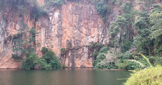
One of three disused quarries around Bukit Timah Hill, Singapore Quarry is last of them to be rehabilitated after operations ceased in late 1970s. After a period of rehabilitation allowing vegetation and wildlife to return, the quarry recovered enough from the destructive quarrying activities to reopen in 2009 as a freshwater wetland park, complete with a viewing platform as well.
There used to be a geocache here that I believe to be disguised as a no-smoking sign. It had long since gotten missing and archived, but if you open up Google Streetview here, you can see a slightly crooked no-smoking sign that isn't here anymore. If that is the cache, then it had been immortalized within the servers of Google. Isn't that incredible?
Singapore Quarry only opened from 7am-7pm.
Look closely at the "twisted steel guardians" here and find the 3-digit number on some of them, not all of them have the number.
Let A be this 3-digit number.
(The sum of the 3 digits is 10)
Hindhede Quarry
N 1° 20.956' E 103° 46.493'
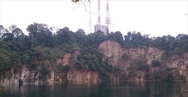
The Hindhede Quarry, named after Danish civil engineer Jens Hindhede who was was a businessman and tea farmer in Singapore and Malaysia in the 20s and 30s, used to be a secret haunt for rock climbers and swimmers. The quarry was declared off-limits in 1997 as its rapidly rising waters became a cause for safety concerns. It reopened as a proper nature park in 2001, but the quarry cliff and lake can now only be appreciated from afar, from the safety of a lookout platform. There is also another "secret" view of the quarry if you approach it from above from the path to the radio station, but make sure to stay away from the edge if you do!
Hindhede Nature Park, where the quarry is located in, is only opened from 7am-7pm.
Find the "protector from thunder", along its surface are letters and a 3-digit number repeated throughout.
Let B be this 3-digit number.
(The sum of the 3 digits is 10)
(It's not a date, look closer)
Poh Hin Quarry
N 1° 21.041' E 103° 45.881'
The abandoned quarry Bukit Batok Nature Park is built around. Some people claim that Bukit Batok means "Coughing Hill" in Malay, refering to the sound of explosives historically used at Little Guilin, but there are others who claim otherwise. A story has it that the hill resembled a skull top and "batok" could also be construed to mean "skull top", scary. At least we can be sure that it isn't named after the English word for a smelly body part.
This park is in fact the place for Singapore's third geocache, but it was muggled and archived within days of publish without a single find. While you are here, you can also check out the memorial plaque identifying the site where Japanese soldiers built a shrine at the top of Bukit Batok to commemorate their dead during World War II.
Let C be the month number of the "DOB" of A5/25.
(Example: January = 1, December = 12)
(The year number should be 14)
Gammon Quarry
N 1° 21.345' E 103° 45.251'

Eventually renamed "Little Guilin" after the famous natural granite karst (thanks ZacharyKZH, I really should stop copy-pasting info from random sites) formations of Guilin in China, it is formally known as Bukit Batok Town Park, which ends up pretty confusing due to 3 parks here having "Bukit Batok" in their names. Little Guilin’s highest point reaches 133m, making it the second tallest hill in Singapore after Bukit Timah Hill. Parts of the 1998 local drama "The Return of the Condor Heroes", starring Fann Wong and Christopher Lee, was filmed here.
At the coordinates you should find a large black boxy structure near the edge. The path over to it should not bring you close to the edge, but watch your footing. Count the number of rivets (look at the photo below) on the TOP SURFACE of the black boxy structure. There is only 1 row of rivets on the top surface and it is on the side away from the edge.
Let D be the number of rivets on the top surface of the structure.
WARNING: WATCH YOUR FOOTING! The structure is close to the edge and you don't have to go too close to count the rivets. And for heaven's sake don't do this WP at night. I am not going to be reponsible if you fall into the quarry.
Seng Chew Quarry
N 1° 21.673' E 103° 45.225'
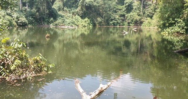
The not-so-secret little quarry that is an optional location for the Earthcache nearby. A little north of this place there used to be an abandoned building thought by some to be a blast shelter, once featured by the One° North Explorers. It has long since collapsed, and if you look to the left while approaching the quarry you can see a little piece of a wall. I heard from a little bird that if you have the courage to bash your way up the north slope (I didn't), you will come across the rest of the ruins.
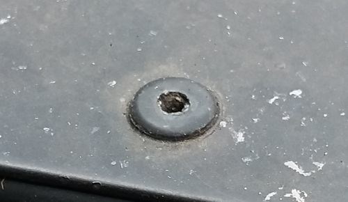
Look closely at the L fence post closest to the fish (or the one just left of the drain when approaching the quarry). Count the number of screws and holes on it and add them together. Adding the number of screws and holes ensure that even if a screw falls out the sum will not change. The photos below shows examples of the screws and holes.
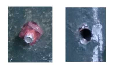
Let E be the sum of the numbers of screws and holes on this post.
(E is an even number)
(Don't forget the hard-to-see hole above the bottommost screw)
Once again, watch your footing. Quarries are known to be far deeper than they look.
Seng Chew Quarry is no longer open to the public. Ignore this waypoint.
The Cache
N 1° 21.XXX' E 103° 45.YYY'
To get XXX, subtract 209 from the first 3 digits of 5*(A*B*C*D).
To get YYY, subtract 330 from the next 3 digits of 5*(A*B*C*D).
Don't miss the 5 in the formula!
The hint for the cache location is within the geochecker:

If there is any problem with the cache or any of the waypoints, please inform me about it.