How did these rocks get here ? Hint-part of the answer is an avalanche. But was it from near or far ?
If the rocks in these mountains could tell their story, they'd describe their birth as sand washed into the warm ancient sea that laid here for millions of years. They'd speak of sinking to the ocean floor and of being covered over by more and more particles and by the crushed bodies and secretions of countless sea animals. They'd describe how the ever increasing weight pressed the sand grains into sandstone, the mud into shale and the lime into limestone. They'd then tell how they were raised high into the heavens - reborn as the Rocky Mountains. About 160 million years ago the Rockies began to form. The mountains here consist mostly of three types of sedimentary rocks:
- Quartz Sandstone
- Limestone
- Shale.
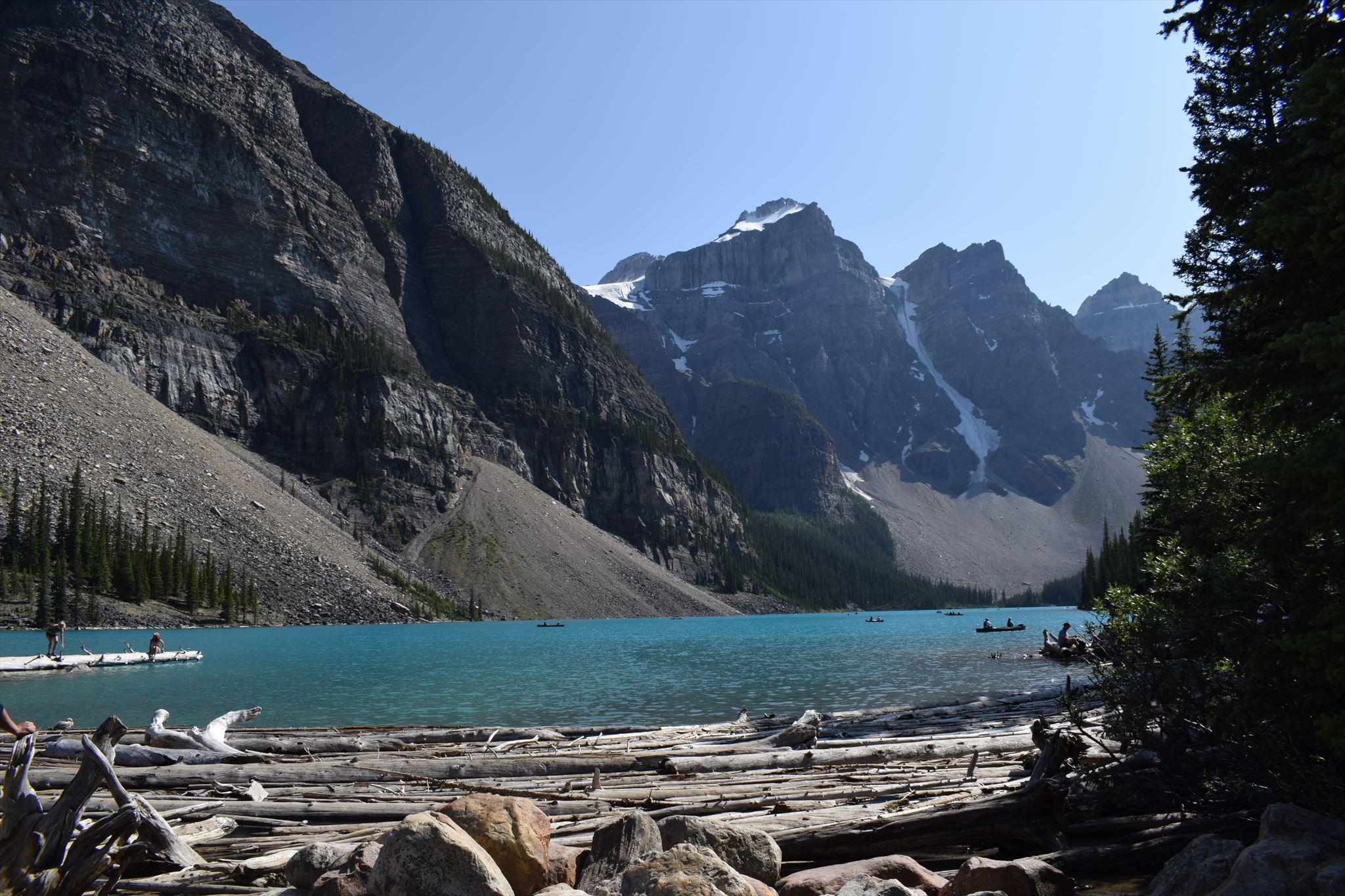
Fig. 1 Moraine Lake
What means "crash" ?
All the time we have a fundamental process of alteration. It is crucial for the development of soil. Moreover, the process of alteration works through exogenous forces:
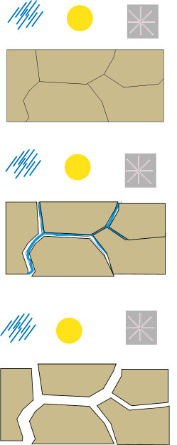
Fig. 2: Initially intense physical weathering. Result: cracks and fissures
Fig. 3: Water fills the cracks, which intensivies the progress of chemical weathering. Result: hollow spaces created by solvents, dissolution of the rock
Fig. 4: Intensive chemical weathering leads to the dissolution of rocks into several fragments.
Freezing water shatters rock and trickers small rock slides. The debris from this slides piles up at the base of the mountains. The sedimentary rock found in these mountains is porous. Rain water and melting snow percolate down through sandstone and limestone and along the separating sheets of shale. As they trickle into cracks, rain and melting snow freeze and expand, splitting even the hardest rock. Loosened by repeated freezing and thawing, frostbroken fragments bounce down the cliffs and collect in cone-shaped piles called talus or scree slopes.
Snow avalanches and rock slides cut swaths through green vegetation. Many large rocks, some weighting several tons, roll and bounce all the way to the bottom.
And now to "carry":
Rock slide crashes down of mountains onto glacier. Slowly the glacier carries the rocks piggyback down the valley. The glacier recedes, dropping the rocks where they are today.
Moraines are formed from debris previously carried along by a glacier, and normally consist of somewhat rounded particles ranging in size from large boulders to minute glacial flour.
Lateral moraines are parallel ridges of debris deposited along the sides of a glacier. The unconsolidated debris can be deposited on top of the glacier by frost shattering of the valley walls and/or from tributary streams flowing into the valley. The till is carried along the glacial margin until the glacier melts. Because lateral moraines are deposited on top of the glacier, they do not experience the postglacial erosion of the valley floor and therefore, as the glacier melts, lateral moraines are usually preserved as high ridges.
Ground moraines are till-covered areas with irregular topography and no ridges, often forming gently rolling hills or plains. They are accumulated at the base of the ice as lodgment till, but may also be deposited as the glacier retreats. In alpine glaciers, ground moraines are often found between the two lateral moraines.
End moraines are ridges of unconsolidated debris deposited at the snout or end of the glacier. They usually reflect the shape of the glacier's terminus. Glaciers act much like a conveyor belt, carrying debris from the top of the glacier to the bottom where it deposits it in end moraines. End moraine size and shape are determined by whether the glacier is advancing, receding or at equilibrium.The longer the terminus of the glacier stays in one place, the more debris accumulate in the moraine. There are two types of end moraines: terminal and recessional. Terminal moraines mark the maximum advance of the glacier. Recessional moraines are small ridges left as a glacier pauses during its retreat.
Medial moraine is a ridge of moraine that runs down the center of a valley floor. It forms when two glaciers meet and the debris on the edges of the adjacent valley sides join and are carried on top of the valley floor is created.
To log this earthcahe, please send the answers to the following questions to my account. You do not need to wait for a log approval. If something is not correct, I will contact you soon.
1. Go to the listing coordinates. Which kind of moraine do you see ? Justify your answer.
2. Describe the formation of deposits (size, shape, colour, kinds of sediments etc.)
3. Near the listing coordinates you find one of the types of sedimentary rocks. According to the plaque, which kind is it ?
Attention: Parking is limited at Moraine Lake and fills quickly during daylight hours, so planning ahead is key. Moraine Lake road opens only when parking is available at the lake. Use public transit or shuttles: parkscanada.gc.ca/banff-transit
Moraine Lake Road is closed to vehicles from mid-October to late-May due to high avalanche risk.
Acknowledgement: I thank the Product Development Officer, Lake Louise, Yoho and Kootenay Field Unit, Parks Canada/Government of Canada for the permission to let this Earthcache be published and the Geoaware for reviewing.
References:
Wikipedia https://nationalgeographic.org/encyclopedia/moraine/
Fig. 1 photo by the owner August 2019