The Tuia Mātauranga GeoTour is about having fun discovering the history of Aotearoa New Zealand by finding sites of significance in local communities from early Pacific voyaging and migration, European settlement to present. The interaction between people, and people and the land, have provided a rich history that the GeoTour invites you to explore.
The theme of this cache is Migration and Settlement
The name Te Taumanu o te Waka a Māui was bestowed upon Kaikōura Peninsula based on the legend of Māui, the Polynesian hero who fished up the North Island (Te Ika a Māui) from his waka the South Island (Te Waka a Māui). Legend has it that as he hauled the great fish up from the ocean depths he took a foothold on the thwart of the waka, which was the Kaikōura Peninsula (Te Taumanu o te Waka a Māui) and placed his foot into the sea creating the Hikurangi Trench and braced his shoulder against the land creating the inland Kaikōura ranges.
Kaikōura – ‘kai’ meaning food and ‘kōura’ meaning crayfish – was a highly desirable place to establish a settlement, from the mountains to the sea, plentiful resources abound. There were birds in the forests, sea mammals colonising the shores, coastal waters teeming with fish and shellfish, nearby stone resources from which to make tools, and forests from which to gather trees and plants. The coast also provided other advantages, high terraces and peaks from which to observe visitors and to provide protection from potential invaders.
Waitaha are believed to have been the first people to arrive and settle the Kaikōura Peninsula. It is unclear when exactly they first arrived but some say it was around the thirteenth century. Little is known of their occupation of the area, but oral tradition states that Waitaha were invaded by Ngāti Mamoe who descended from the North Island during the sixteenth century, defeating Waitaha in battle and ousting them from the land. And so began a cycle of invasion and conquest. Ngāti Mamoe in turn were displaced and defeated when another North Island tribe, Ngāi Tahu, invaded Kaikōura in the seventeenth century. Like Waitaha before them, Ngāti Mamoe were essentially absorbed into the victorious iwi via intermarriage and conquest.
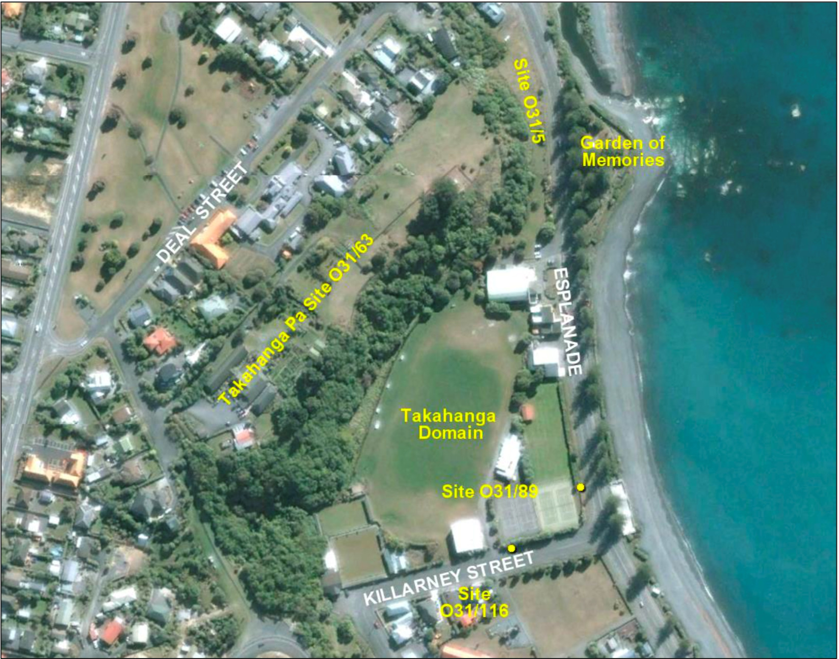
Figure 1: Key locations near GZ including Takahanga Pā and the mouth of Lyell Creek, which can be seen immediately north of the Garden of Memories (Source: ArchSite)
Ngāi Tahu maintained a strong position of power in Kaikōura until 1828, when they were invaded by a northern chief by the name of Te Rauparaha. Te Rauparaha, from the Ngāti Toa tribe, was a war leader with a fearsome reputation. Since 1819, Te Rauparaha had been on a campaign of intertribal warfare and had proven himself to be a formidable strategist. In 1828 he set his sights on Ngāti Kuri, he travelled along the Kaikōura coast during the pre-dawn hours with his warriors concealed aboard waka. He had invaded Kekerengu Pā and captured some of the inhabitants whom he took with him and forced to wave to Ngāti Kuri who had gathered on the beach. Ngāti Kuri had been expecting visitors from Kekerengu and made no attempt to raise a defence as they welcomed their friends. As the waka approached the shore under the guise of friendship, Te Rauparaha could see they were undefended and rushed the beach having his warriors attack the unsuspecting Ngāti Kuri who had gathered there. The people attempted to flee to Takahanga Pā, but they stood little chance as they had no defense against the musket clad warriors. A few old men and boys made it to the pā, closed the gates and launched a defense, but it was to no avail.
Te Rauparaha and his warriors swept across the peninsula to South Bay where they killed more Ngāti Kuri who lived in one of the terrace pā. Approximately 1400 Ngāi Tahu were killed during the invasion and many others were taken as captives. In 1827 there were said to have been between three and four thousand Māori in Kaikōura, thirty years later there were approximately 78 Māori between Clarence and the Conway, demonstrating the devastating impact this battle had on the population. Despite their losses Ngāi Tahu managed to hold their lands and Ngāti Toa did not settle in Kaikōura.
Te Rauparaha’s invasion of the South Island also had a profound effect on European settlement. The killing and displacement of so many Māori left large areas that had once been teeming with life suddenly unoccupied making it easier for Europeans to settle in these areas. There was less of a chance of opposition and a lower risk of confrontation. With large numbers of European settlers arriving over short periods of time Māori were soon outnumbered by pākehā.
Robert Fyffe established the first European settlement in Kaikōura when he built the Waiopuka Whaling Station on the peninsula in 1843. For many years this was the commercial and social centre of the district with people travelling to the station for supplies from the local store, to hear sermons at Fyffe House and to take shelter as they passed through. Following the Kaikōura Deed of Purchase by the Crown in 1859, sections of land became available and settlers started moving into the area during the 1860s.
In 1862 the Traveller’s Rest was established on West End Road and soon other small businesses, hotels and whare began to spring up in the area, as well as St Paul’s Presbyterian Church which was built on the hillside below Takahanga Pā (Figure 2). The pā was still occupied at this time but there were very few Ngāti Kuri remaining in the village. In the 1870s they still had waka at their landing site near the mouth of Lyell Creek and they had a flourishing garden on the land reserve at the corner of Killarney Street and the Esplanade.
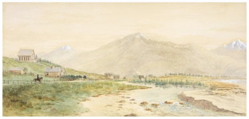
Figure 2: An early sketch of West End Road (Gibb, c.1883) depicting the mouth of Lyell Creek and St Paul's Presbyterian Church on the hill
The European township began to grow and buildings were soon erected at the East End of the settlement along the edge of Killarney Street – which ran alongside Takahanga Domain, the Ngāti Kuri land reserve – and soon spread out along the Esplanade (Figure 3). The police station, gaol, courthouse, schoolhouse and post office were all situated in this area. There was a competitive attitude between the West End and East End with both settlements aiming to be the main centre of town. The West End had a reputation as being debaucherous whereas the East End was considered to be sophisticated. Eventually the East End became more residential and West End became the centre of town.
The Māori residents eventually left Takahanga Pā and the site became the location for the new hospital. Many young Māori assimilated into European culture and intermarried with pākehā settlers creating a new and distinct culture. Their descendants are still present in Kaikōura, and in Ngāti Kuri, and the reserve that was once Takahanga Pā is now also the site of Takahanga Marae.
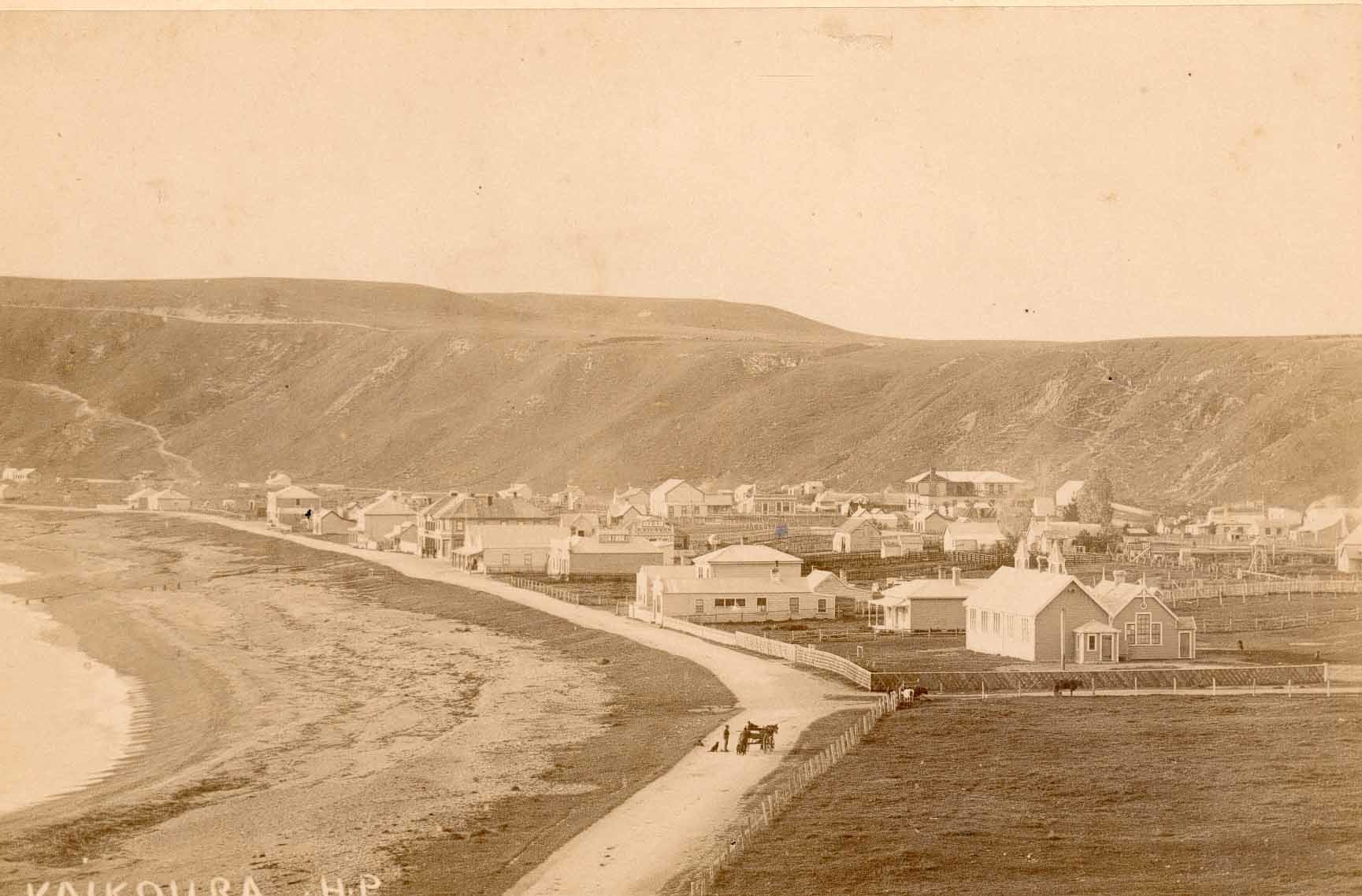
Figure 3: East End looking south along the Esplanade and over Killarney Street prior to the planting of the Norfolk pines (Source: Kaikōura Museum)
What can you see from GZ?
The cache is situated at the neck of the Kaikōura Peninsula. Pre-European Māori occupation occurred all along the Esplanade and on the surrounding terraces. Evidence of early occupation, in the form of ovens, artefacts, and numerous burials, have been found at many locations along the Esplanade including Takahanga Domain, Kaikōura Primary School and the Mayfair, all of which are visible from GZ. Te Rauparaha’s invasion began just north of this location near Lyell Creek and culminated at Takahanga Pā which is situated on the terrace visible to the north-west. West End is now the central township. East End was located up Killarney Street and along the Esplanade but only a few original buildings remain. If you proceed up Killarney Street you will see the former Post Office, now the Albatross Inn, near the corner or Torquay Street.
Further Information
If you wish to learn more about the history of Kaikoura there are a number of very good books available including; 'Kaikoura: A History of the District' by J.M. Sherrard and W.J. Elvy's 'Kaikoura Coast; the history, traditions and Maori place names of Kaikoura'. If you would like a more visual lesson than you can always visit Kaikoura Museum.
To complete this Geotour and receive your special geocoin, remember to take note of the codeword on the log book of the cache. This will need to be recorded in your passport which can be downloaded from here. If the passport is unavailable for any reason just keep a note of the codeword and try again later.