The Tuia Mātauranga GeoTour is about having fun discovering the history of Aotearoa New Zealand by finding sites of significance in local communities from early Pacific voyaging and migration, European settlement to present. The interaction between people, and people and the land, have provided a rich history that the GeoTour invites you to explore.
The theme of this cache is First Encounters and European Settlement
Little is known about the very first contact between Māori and Europeans in Kaikōura. There is no record of sealers attempting to establish themselves in the area, so it is likely that the very first encounters were between Māori and off-shore whalers. In 1834, eight whaling ships were operating from Kaikōura and presumably they would have met with Ngāti Kuri (the local hapū) in order to establish trade and exchange for food and other products.
During the 1830s whaling was a major commercial industry in New Zealand and Robert Fyffe, a Scottish immigrant, saw an opportunity to establish a shore based whaling station in Kaikōura. Plans for construction began in 1842, and became a reality when Fyffe secured a site that could meet the needs of his business. In 1843 construction began and very soon thereafter Waiopuka Whaling Station was established (Figure 1). This was the first shore based whaling station to be built on the Kaikōura Coast and with its foundation it became the first European settlement in the area.
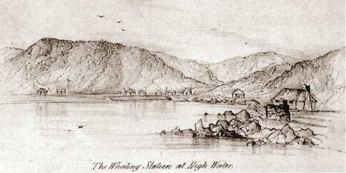
Figure 1: Waiopuka Whaling Station c.1852 looking towards Armers Beach where numerous small huts can be seen (Source: Kaikōura Museum)
Whaling stations were sites where Māori and Pākehā first came together in earnest for a common purpose, working together every day and learning each other’s customs and cultures. Fyffe employed many local Māori men in his whaling crews along with men from Australia, Great Britain, Germany, Hawaii, North America, France and India. Many of these foreigners married Ngāi Tahu women and their descendants still live in Kaikōura to this day. Whalers and sealers were the first settlers in many parts of the country, establishing contact with local iwi and building relationships based on trade and often resulting in intermarriage.
Many small buildings and structures were erected to accommodate the growing settlement. Small huts were seen dotted along Fyffe Quay and over by Fyffe Cove, which is the gap between the hill slopes that are located to the west of Waiopuka Beach (Figure 1). This beach was later renamed Armer’s Beach after Jimmy Harmer one of the local characters who occupied a hut between Fyffe Cove and Waiopuka Beach (Figure 2). Whale bones were abundant in the area and were utilised in many ways including the construction of fences and building foundations.
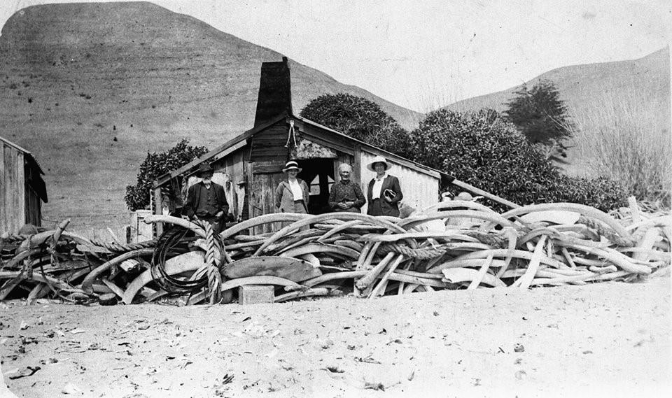
Figure 2: Jimmy Harmer's Hut surrounded by a whale bone fence c.1915 (Source: Kaikōura Museum)
Whaling was a seasonal activity that involved intercepting right and humpback whales as they made their annual migration north. In its first year Waiopuka Whaling Station did considerably well with the collection of 130 tuns of oil. However, the success of the whaling industry was short lived as whalers destroyed their own means of livelihood by hunting mostly cows who had come close to shore to calve. There was a marked downward trend from 1843 and by 1850 shore whaling for right whales was virtually at an end. Whaling continued at the station until 1866, at which point it closed for several seasons, reopening in 1874, but after several failed seasons – in 1877 only one small whale was caught – the Waiopuka Whaling Station was officially closed in 1879.
Fyffe House is a distinct landmark in Kaikōura, known for its pink exterior and prime location. Constructed in 1844 it is the oldest surviving building in Kaikōura and the last remnant of the Waiopuka Whaling Station (Figure 3). It was originally a two-room cottage that housed the cooper, an essential member of the whaling community who made barrels to hold whale oil. The house was extended during the 1860s by Fyffe’s cousin George Fyfe who took over the property following Fyffe’s accidental death in 1854.
Other remnants can be seen (Figure 3), including the fireplace of the custom house which was erected in 1869 and stands across the road from the grounds of Fyffe House. The Pier Hotel, which was built in 1885, was once situated on the front lawn of the grounds and the remnants of its foundations can be seen there still. The hotel sat near the old wharf for 24 years before being relocated to its current location on Avoca Street. The old wharf is still present and operational, though more so by local fishers these days.
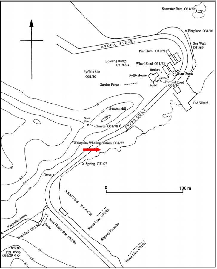
Figure 3: Map showing the sites associated with Waiopuka Whaling Station many of which are still visible today (Source: ArchSite)
About this Multi-cache
This is a simple multi-cache that can be driven, or if you feel like checking out some of the remaining features of the Waiopuka Whaling Station I would recommend taking the short walk between the two waypoints and searching for any visible features (Figure 3). There are a lot to be found!You can start at either location, parking is available at both stages.
Stage 1: Fyffe House
The published coordinates bring you to Fyffe House. You are welcome to enter the property day or night and parking is available on the grounds if the gates are open, otherwise there is a pull over area across the road. Explore the grounds and you will see some of the features listed in Figure 3 as well as a few other points of interest. Picnic tables are available if you wish to stay a little longer and enjoy a meal. During opening hours visitors can look through Fyffe House for a small fee.
Puzzle: What is the three digit number on the plaque? Digits = ABC
Stage 2: Jimmy Armers Beach
The second waypoint will bring you to a sign which you will need to search to discover the answer for the second stage. Parking is available nearby as well as an ablution block. From the sign, or the carpark, I highly recommend taking a walk down to the beach and having a look for whale bones. These are often exposed where the Waiopuka Stream terminates onto the beach. At the time of writing there were two large whale skulls and a large rib visible. Bones are exposed during tidal events or after heavy rainfall, just be aware that they cannot be removed from the beach as they are part of a protected site.
Puzzle: At the posted coordinates what year was the photo taken in Figure 2? Date = 1DEF
Final location: S42 24.(D-E)(D-B)(B+E) E173 42.(F)(C-A)(B+B)
Checksum: A + B + C + D + E + F = 23
Further Information
If you wish to learn more about the history of Kaikoura there are a number of very good books available including; 'Kaikoura: A History of the District' by J.M. Sherrard and W.J. Elvy's 'Kaikoura Coast; the history, traditions and Maori place names of Kaikoura'. If you would like a more visual lesson than you can always visit Kaikoura Museum.
To complete this Geotour and receive your special geocoin, remember to take note of the codeword on the log book of the cache. This will need to be recorded in your passport which can be downloaded from here. If the passport is unavailable for any reason just keep a note of the codeword and try again later.