
The Tuia Mātauranga GeoTour is about having fun discovering the history of Aotearoa New Zealand by finding sites of significance in local communities from early Pacific voyaging and migration, European settlement to present day. The interaction between people, and people and the land have provided a rich history that the GeoTour invites you to explore.
---
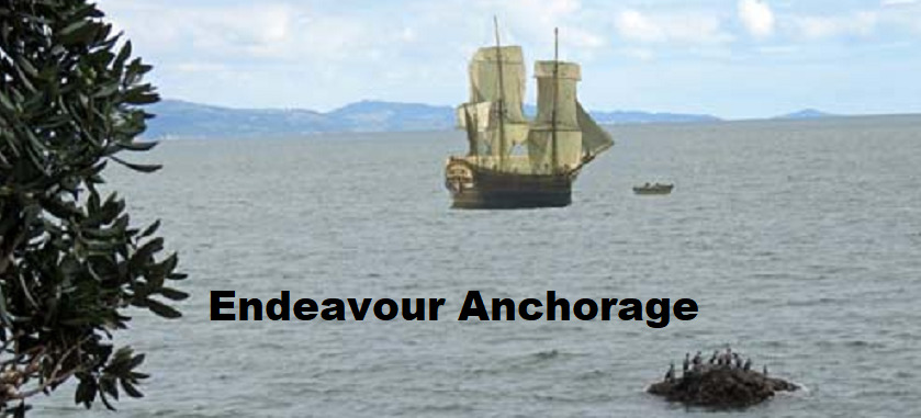
The Endeavour's anchorage in the Firth in 1769 is one of three main sites of interest related to Cook's visit to the Firth of Thames area. How accurately can we pinpoint the location?
Cook wrote in his journal: “After having run about five leagues from the place where we had anchored the night before, our depth of water gradually decreased to six fathoms; and not chusing (sic) to go into less, as it was tide of flood, and the wind blew right up the inlet, I came to an anchor about the middle of the channel, which is near eleven miles over; after which I sent two boats out to sound, one on one side, and the other on the other.The boats not having found above three feet more water than we were now in, I determined to go no farther with the ship, but to examine the head of the bay in the boats . . . At day-break, therefore, I set out in the pinnace and long-boat, accompanied by Mr. Banks, Dr. Solander, and Tupia; and we found the inlet end in a river, about nine miles above the ship...”
So we know the ship was anchored in 6 fathoms of water, at a spot about 9 miles from the mouth of the Waihou River and about the middle of the channel, which is near 11 miles across.
In an attempt to determine the location of the anchorage with some degree of accuracy, Dave Wilton imported a modern nautical chart into Google Earth. Cook’s anchorage depth of 6 fathoms is equivalent to 11 metres. The Waihou 'river mouth' used in the constructions was the estimated 1769 mouth, as determined by Phillips (2000) and is about 1 nautical mile south of the present mouth.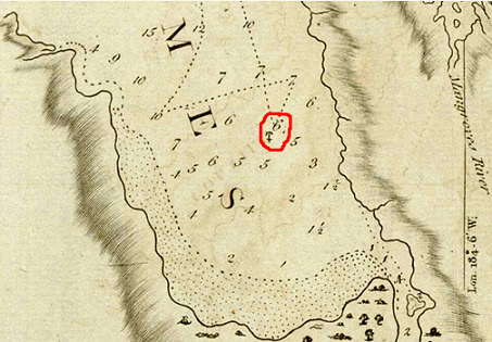 First Dave plotted an arc of 9 nm from the 1769 Waihou river mouth, then he looked at the depth contours. He found the arc to be 1.3 nm short of the modern 11 metre depth contour, though depth is likely to be an unreliable measure given the silting due to draining of the Hauraki plains around 1910 and ongoing farming activity.
Dave Wilton plotted two possible locations, one using the 6 fathom (11 metres) depth and one at the arc 9 nm from the 1769 river mouth. When Cook's chart was superimposed on the NZ533 nautical chart in Google Earth, Cook's anchorage as marked on his chart coincided with the estimated locations, and fitted perfectly with the 9 nm arc. He concluded the best estimated location of Endeavour's anchorage is west of Te Puru, or alternatively west of Waiomu. The reconstruction also demonstrated the high quality of Cook's original survey work.(See gallery for Cook's Map of Thames)
The cache is hidden at Te Puru where there is a wonderful view over the Firth of Thames and the site of the Endeavour Anchorage.
---
To be able to complete this Geotour and receive your special geocoin, remember to take a note of the codeword on the log book of the cache. This will need to be recorded in your passport which can be downloaded from here. If the passport is unavailable for any reason just keep a note of the codeword and try again later.