
<<!--Hlavička kešky-->
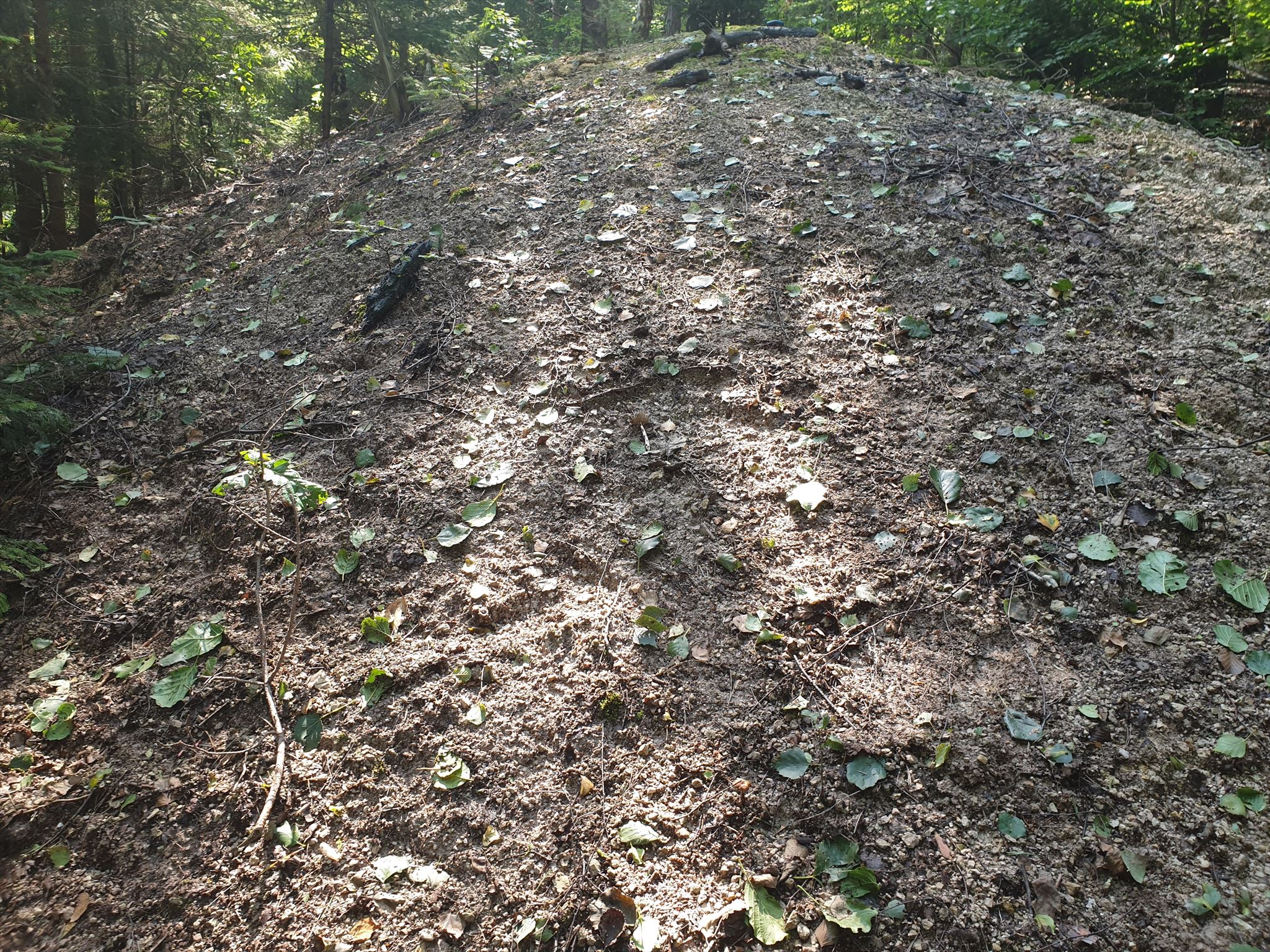
Haldy.
Keška
Na lokalitu sa dostanete po lesnej ceste, na ktorú odbočíte z hlavnej. Auto môžete zaparkovať na waypointe parking (waypoint P1), oproti autobusovej zastávke, alebo pri družstve (waypoint P2). Nespevnenými cestami sa dostanete blízko ku haldám. Spodná trasa je neprejazdná (hneď za chatami pri vstupe do lesa je závora), vrchnou sa dá teoreticky dostať až k posledným chalupám pod Veľkým Lyscom, odtiaľ krížom cez lúku až ku keške.
Ak idete spodnou trasou od zastávky, odporúčam v lese prejsť cez mostík (waypoint BR) taktiež na lúku a po nej na úroveň kešky a až potom cez lesík. Haldy sú v lesnom poraste, priamo k nim nevedie žiaden chodník. Samotné štôlne sú prakticky neviditeľné, jediným príznakom ich existenice je mláka pred bývalým portálom štôlne Karol.
Pre zalogovanie tejto earthcache musíte zodpovedať na nasledovné otázky a zaslať mi odpovede na e-mail cez profil:
- Hauerit je jednoduchý minerál, tvorený len dvoma prvkami. Mangánom a...? (listing)
- Aký je zdroj druhého prvku na ložisku? (listing)
- Porovnajte vyťažený materiál háld s okolitými, neporušenými horninami (rôzne veľké úlomky andezitových skál sa vyskytujú popri ceste). Aký je rozdiel vo farbe? Je hornina na haldách kompaktná, alebo rozdorbená?
- Na waypointe SP (Mineral spring) sa nachádza prameň miestnej minerálnej vody. Jej zloženie priamo súvisí s postvulkanickou činnosťou, ktorá dala za vznik aj ložisku. Popíšte vlastnými slovami jej vôňu a farbu.
- Urobte si fotku Vás, alebo Vášho zariadenia (Vášho SWG) niekde na lokalite.
Zalogovať môžete aj bez čakania na potvrdenie správnosti odpovedí, ak bude niečo zlé, budem Vás kontaktovať. Logy bez odpovedí budú po troch dňoch zmazané.
Ak logujete ako skupina, stačí jedna sada odpovedí za všetkých (so zoznamom iných nickov), ale zvyšok skupiny sa musí zalogovať taktiež do troch dní. Inak, každý logujúci posiela vlastné odpovede.
A na záver: nebojte sa odpovedí, skúste ;-)
A čítajte listing, možno Vám to pomôže.
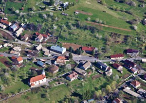
Letecký pohľad na obec.
Vígľašská Huta-Kalinka
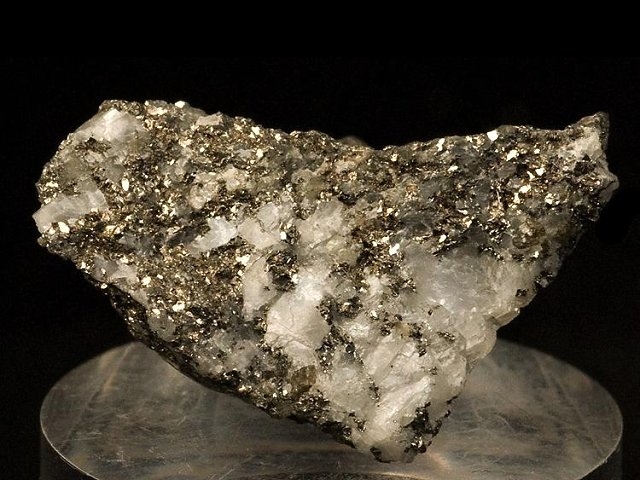
Obec leží na západných severovýchodných svahoch pohoria Javorie. Jej územie je budované vulkanickými horninami, prevažne andezitmi a ich pyroklastikami. V oblasti vrchov Banisko a Skalka sa vyskytujú aj malé intrúzie dioritov a dioritových porfýrov.
Na zlomovej línii medzi obcami Vígľašská Huta-Kalinka, Klokoč a Stožok sa nachádza pásmo hydrotermálne premenených hornín s celkovými rozmermi 10 x 2 km. Diority sú silne premenené solfatárovou činnosťou, unikajúcimi plynmi z fumarol bočného krátera stratovulkánu Javorie. Viacero minerálnych prameňov v okolí obce, resp. v susedných obciach je posledným prejavom tejto aktivity.
Vplyvom kyslého prostredia, keď chemickými reakciami medzi sírnymi plynmi fumarol, vzdušným kyslíkom a vodou vzniká kysleina sírová a vyšších teplôt dochádza k rozkladu dioritov za vzniku pestrej minerálnej asociácie. Okrem síry sa na ložisku bežne vyskytoval kremeň, pyrit, sadrovec, anhydrit a kalcit.
Síra samotná vzniká rekaciami:
2 H2S + 3 O2 = 2 SO2 + 2 H2O
2 H2S + SO2 = 3 S + 2 H2O
prípadne priamo, iba čiastkovou oxidáciou sírovodíka:
2 H2S + O2 = 2 S + 2 H2O
Ložisko síry vo Vígľašskej Hute-Kalinke bolo v minulosti jediné ťažené ložisko síry na Slovensku. Tažba sa započala v roku 1823 spoločnosť založená prof. Zipserom z Banskej Bystrice, no za krátky čas bola ukončená. Znovu otvorená bola v roku 1842 štôlňami Karol, Tág a Zubau. Bane boli v prevádzke 15 rokov a v 1862 ťažba definitívne zanikla. Z celé obdobie sa vyťažilo odhadom asi 160 t síry. V súčasnosti je lokalita zanedbaná, štôlne sú prakticky nepozorovateľné a jediným dôkazom banskej činnosti sú haldy, ktoré však tiež pomaly zarastajú vegetáciou.
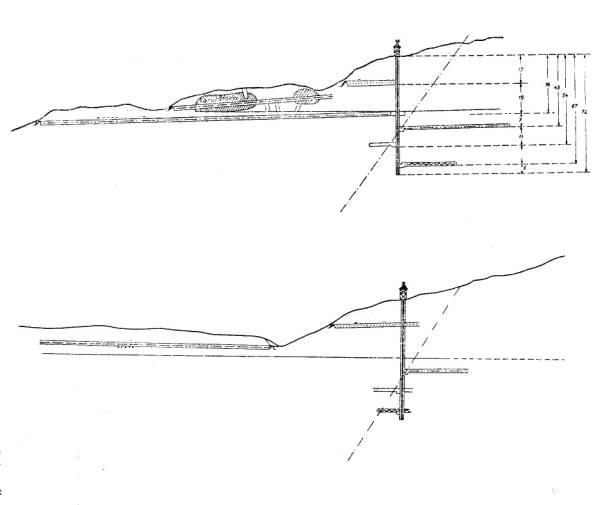
Banské diela v okolí Vígľašskej Huty-Kalinky.
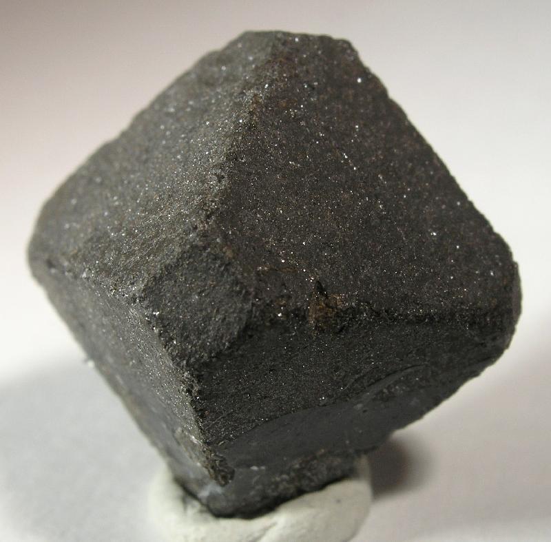
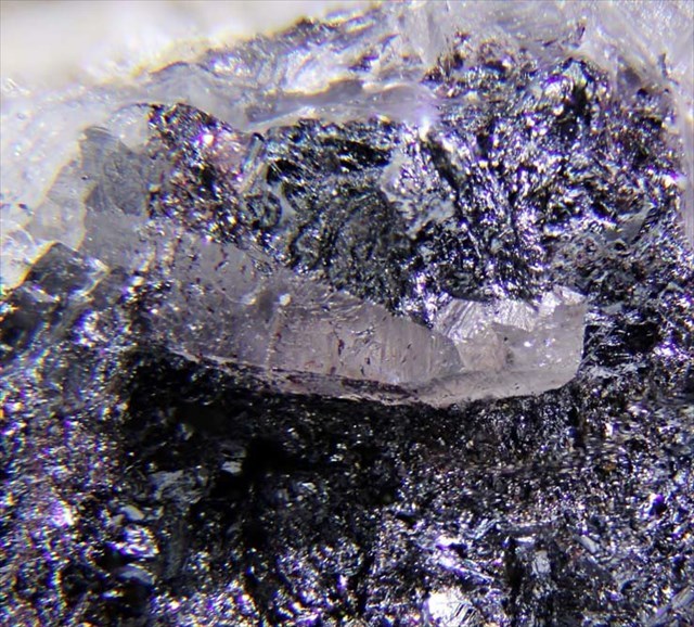
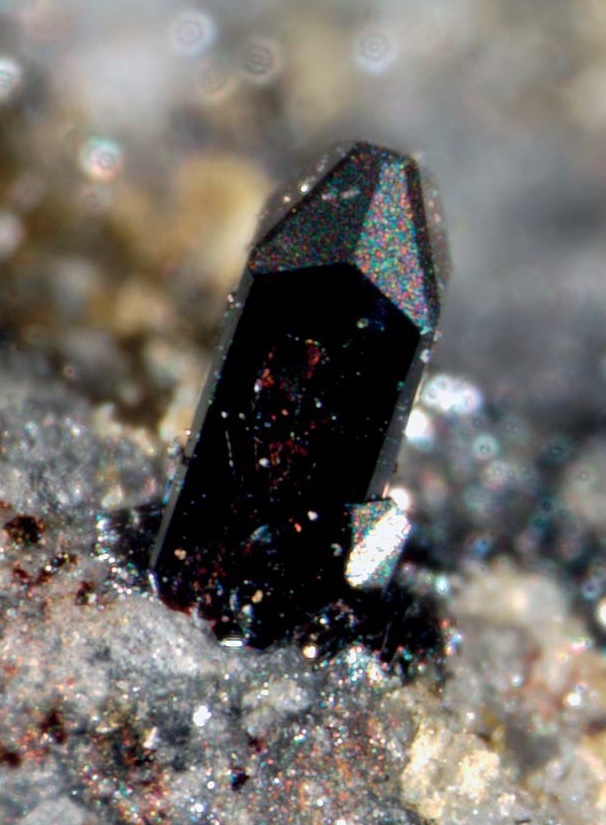
Hauerit.
Hauerit
Hauerit je minerál kryštalizujúci v kubickej sústave. Objavený bol v 1846 na ložisku síry vo Vígľašskej Hute a pomenovaný je podľa rakúskych geológov Josephovi Ritter von Hauerovi a Franzovi Ritter von Hauerovi. Jeho vznik priamo súvisí so solfatárovou činnosťou, zdrojom mangánu sú rozložené pyroxény hedenbergitového radu a zdrojom síry solfatárové plyny (sírovodík). Na ložisku tvoril malé, maximálne 2 cm veľké oktaédrické kryštály.
Vlastnosti:
- Chemický vzorec: MnS2
- Trieda: sulfidy a sulfosoli
- Farba: šedočierny, hnedočierny
- Tvrdosť: 4 (Mohs)
- Lesk: kovový
- Hustota: 3,363 g.cm-3
- Kryštálová sústava: kubická
Heaps.
Cache
You can park your car at the waypoint P1, opposite to the bus stop, or at the waypoint P2. Then you walk on unpaved roads close to the plies. The lower route is impassable for car (at the entrance to the forest is a barrier), by the upper one you can get up closer, near last buildings and then accros the meadow to the cache.
If you take the bottom route, I recommend you cross the bridge (waypoint BR) to the meadow, then by the border between the meadow and the forest to the level of the cache and then through the forest. The heaps are in the forest; no pathway leads directly to them. The adits themselves are practically invisible, the only sign of their existence is a small water body in the front of the former portal of the Karol adit.
For logging this cache send me please an e-mail through my profile with the answers to the questions bellow:
- Hauerite is a simple mineral. It consists of two elements. Manganese and...? (listing)
- What is the source of the second element? (listing)
- Compare the rest of mined material on the heaps with unaltered rocks, wich you can find along the roads. Is there difference in color? Is the material on the plies compact or not?
- On the waypoint SP (Mineral spring) is a spring of mineral water. It's a result of postvulcanic activity in the region. In your own words, describe the color and smell of the water.
- Take photo (you, your GPS, or other personal thing) somewhere in the locality.
After then, you can log the earthcache - if there is something wrong, I will contact you. Logs without answers will be deleted after 3 days.
If you log as a group, one message with the answers (and the list of other visitors' nicknames) is enough, but the others must log in 3 days. Otherwise, everyone must send his or her own answers.
And most of all - don't be afraid of the answers, just try ;-)
And read the listing, maybe it will help you.
Aerial view of the village.
Vígľašská Huta-Kalinka
Vígľašská Huta lies on the northeast slopes of the Javorie mountain range. It is an old volcanic mountain range, the last activity being 15-13 mil. years ago. It is composed mainly from andesites, or andesite pyroclastics. Near the Banisko and Skalka hills, there are also small intrusions of diorites and diorite porphyres.
Between Vígľašská Huta, Stožok and Klokoč is a large fault zone with hydrothermally altered rocks. Diorites were severely altered from gases of fumaroles from the parasitic cone of a stratovolcano. As a rest of this activity, there are some mineral springs in the villages and their vicinity.
Due to the influence of sulfuric acid, created by rections between fumarolic gases, air and water a higher temperature of fumarolic gases, the diorites completely decomposed with creation of quartz and other minerals.
Elementary sulfur is created by the formula:
2 H2S + 3 O2 = 2 SO2 + 2 H2O
2 H2S + SO2 = 3 S + 2 H2O
or directly, by partial oxidation of hydrogen sulfide:
2 H2S + O2 = 2 S + 2 H2O
The sulfur deposit in Vígľašská Huta is the only sulfur deposit in Slovakia which was mined in the past. Mining started in 1823, but after a short period of time was closed. Reopening in the 1842 till 1862 produced 160 tons of sulfur. Is difficult to reach the locality now. The adits and shaft are not visible, and only the piles are proof of mining activity there.
Mines in the Vígľašská Huta-Kalinka.
Hauerite.
Hauerite
Hauerite is a mineral, which was discovered in 1842 in the Vígľašská Huta-Kalinka sulfur deposit and is named after Austrian geologists Joseph Ritter von Hauer and Franz Ritter von Hauer. It forms reddish brown or black octahedral crystals and it occurs in low temperature, sulfur rich environments associated with solfataras in association with native sulfur, realgar, gypsum and calcite.
Properties:
- Formula: MnS2
- Mineral class: sulfides and sulfosalts
- Color: brown, black
- Hardness: 4 (Mohs)
- Lustre: metallic
- Specific gravity: 3,363 g.cm-3
- Crystal system: isometric
Táto keška je súčasťou série earthkeší, venovaných minerálom s typovou lokalitou na Slovensku.
This cache is a part of EarthCache series, dedicated to the minerals with type locality in Slovakia.
Lokalita
Locality |
Minerál(y)
Mineral(s) |
Objavený
Discovered |
| Hodruša-Hámre |
 |
Hodrušit |
Cu8Bi12S22 |
1970 |
| Ľubietová |
 |
Euchroit |
Cu2AsO4(OH)·3H2O |
1823 |
 |
Libethenit |
Cu2PO4(OH) |
1823 |
 |
Mrázekit |
Bi2Cu3(PO4)2O2(OH)2·2H2O |
1992 |
| Meteorit Magura |
 |
Cohenit |
Fe3C |
1889 |
 |
Schreibersit |
(Fe,Ni)3P |
1847 |
| Pernek |
 |
Schafarzikit |
FeSb2O4 |
1921 |
| Vígľašská Huta-Kalinka |
|
Hauerit |
MnS2 |
1847 |
| Župkov |
 |
Tetradymit |
Bi2Te2S |
1831 |
Zdroje/Sources