The Tuia Mātauranga GeoTour is about having fun discovering the history of Aotearoa New Zealand by finding sites of significance in local communities.
Isolated for millions of years, this country developed into a beautiful archipelago with beaches, rivers and lakes, mountains and plains. Eighty five per cent of the native animals and plants are unique to this land. A land rich in resources.
New Zealand has a history of exploration, voyaging and migration. Many generations ago the exceptional feats of Pacific voyagers, using traditional skills and knowledge, crossed Te Moana-nui-a-Kiwa (the Pacific Ocean) to settle here.
In 1769 the Endeavour navigated by Lieutenant James Cook and Tahitian high priest Tupaia reached New Zealand shores. The interaction between people, and people and the land, have provided a rich history that the GeoTour invites you to explore.
The theme of this cache is Settlement
The Kaikōura Peninsula is a terraced landscape that is approximately 10 kilometres long. Headlands jut out into the sea and provide ideal platforms from which to survey the northern and southern coast. Pre-European Māori pā engineers were adept at choosing sites with natural advantages which could be enhanced to create a defensive structure. Kaikōura Peninsula presented an ideal location for pā sites with its natural vantage points, precipitous cliffs, headlands and coastal access to the sea with all of its resources.
During the pre-historic period, Māori occupied undefended village sites, generally close to river mouths or areas where there were abundant food resources. There they planted and harvested cultivation areas, trapped birds, caught fish and gathered kai moana (seafood). When intertribal warfare began, defensive structures became necessary and pā were created as areas for villagers to withdraw to in times of trouble. Walls were constructed and topped with palisades, entry was permitted through narrow gates which could be barred to keep invaders out, food was stored in pits within the walls and watchmen occupied towers around the perimeters. When under attack, rocks could be thrown from the towers and spears could be thrust through the palisades.
Along the Kaikōura Peninsula there are no less than fourteen pā. These pā were occupied at different stages over a 300 year period and were constructed by Ngāti Mamoe and Ngāi Tahu. To the south of the cache location is South Bay Pā which overlooks South Bay (Figures 1 and 2). This pā has three defensive walls that are still visible today. It is unknown when this pā was occupied although it is certainly one of the largest and most prominent pā along the terrace edge. Farther south is another pā overlooking the entrance to Te Waero o te Hiku, with a single defensive wall, which is believed to have been occupied at the time of Te Rauparaha’s 1828 invasion. The unprepared inhabitants were overcome by the Ngāti Toa warriors. Over 1400 Ngāti Kuri were captured and killed in Kaikōura during the raid and the Ngāti Kuri population was decimated.
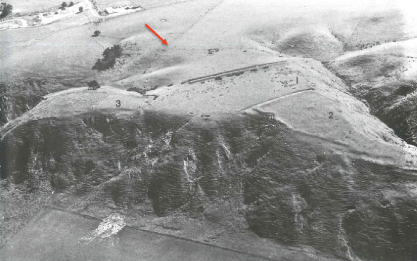
Figure 1: Photograph of South Bay Pā taken from the south, showing several defensive walls. The red arrow indicates the area where the cache is located (Source: ArchSite)
Pā were excellent defensive structures, capable of withstanding attack from invading forces, but they had their limitations. Māori were by all accounts fantastic and powerful warriors who fought with hand to hand combat and did not use projectiles, despite carrying spears. With the arrival of Europeans came the introduction of the musket, a weapon that altered combat for Māori and changed the way pā were designed. Walls became thicker and higher, taking on a more defensive structure and trench warfare was developed. These innovations did not quite make it to Kaikōura although many excellent examples can be seen in Waikato and Northland. The hostility and force of Te Rauparaha's invasion ceased the development of musket warfare on the Peninsula.
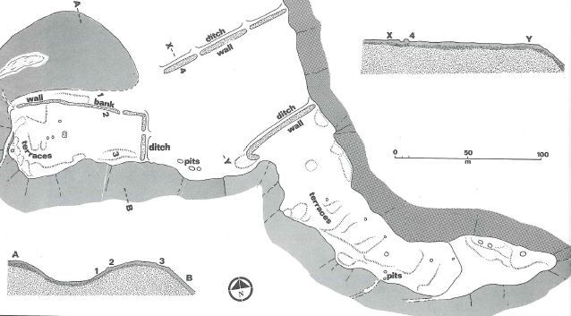
Figure 2: South Bay Pā showing the recorded structures and features visible in Figure 1 (Source: ArchSite)
It is unclear when the terrace edge pā ceased to be occupied in Kaikōura. Records show that Takahanga Pā, which is located on the terrace edge above the Kaikōura township, was occupied up until the late 1870s. There were few Ngāti Kuri left in Kaikōura following Te Rauparaha’s invasion, certainly not enough to defend a pā, so they may have been abandoned at this time. During European settlement Māori became accustomed to the pākehā style of living and during the nineteenth century they quickly adapted and eventually moved away from pā life. These amazing structures still stand sentry today in areas all around New Zealand as proud remnants of our past.
What can you see from GZ?
At the cache location, if you can look to the south you will see the earthworks for South Bay Pā (Figures 1 and 2). Large defensive walls that would have once been topped with palisades protrude from the long grass. The openings along the walls were the locations of the gates into the pā. To the south-east you can see the southern extent of the Kaikōura Coast and the access way that would have led down to the bay. If you park on Scarborough Street you can take one of the two tracks down to South Bay, or loop around before heading back to your vehicle. You may even see a few more terrace edge pā on your journey.
Further Information
If you wish to learn more about the history of Kaikoura there are a number of very good books available including; 'Kaikoura: A History of the District' by J.M. Sherrard and W.J. Elvy's 'Kaikoura Coast; the history, traditions and Maori place names of Kaikoura'. If you would like to know more about pā in Kaikoura and around the country there are numerous texts but the most simple of which is 'The Tattooed Land' by Barry Brailsford. If you would like a more visual lesson than you can always visit Kaikoura Museum.
To complete this Geotour and receive your special geocoin, remember to take note of the codeword on the log book of the cache. This will need to be recorded in your passport which can be downloaded from here. If the passport is unavailable for any reason just keep a note of the codeword and try again later.