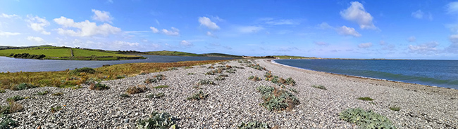
Welcome to Esgair Gemlyn - a unique shingle ridge which forms a beautiful curved natural barrier between the bay and the lagoon.
Things to Know Before You Arrive...
There are a couple of things to note so please read this first.
Don't be put off if the questions look long. I've done all the writing so you can choose from the options making your paperwork very light! It really is extremely simple when you read it.
There is a public footpath along the ridge however the main path is closed between April 1st and August 31st due to ground nesting birds on the ridge. This is because the nests and eggs of birds may be camoflaged and easily damaged. During this time you are asked to follow the marked route and remain on the beach below the white markers. This may prevent you crossing the ridge at high tide. All the questions can be answered without contravening the closure, so please respect it.
You can get to the ridge at most times, but be aware it may not be possible to access the ridge at high tide from Byrn Aber (you might need wellies!) and at very high tides the Byrn Aber Car Park may flood. There shouldn't be any tidal access issues from the other side. The general advice would be to avoid visiting when the tide is at the highest although you may still be able to complete the EarthCache with suitable dress and/or planning.
Because of the reasons explained in the listing, the whole area is an SSSI (Site of Special Scientific Interest) managed by the National Trust. Permission has been granted for this EarthCache but please remember the area is in need of special care and protection so whilst you are welcome to visit, please don't interfere with anything and respect any limitations that may be in place.
Geology and History of Esgair Gemlyn
On one side of the ridge is the bay with the waves of the sea crashing onto the ridge, moving stones and continually changing the profile of the ridge. On the other side is the a complex area of lake, salt marsh and 'saltings', which are low islands regularly inundated by high tides.
Nearby you can see tall brick walls, behind which stands Bryn Aber. This is a house built by Captain Hewitt, the first man to fly across the Irish Sea in 1912. Eighteen years later he returned to Anglesey to buy Bryn Aber, where he lived a reclusive life until his death in 1965.
The house name itself is actually geological. The Bryn is the hill next to the house, actually a drumlin formed in the ice age by glaciers heading south west from the Irish Sea across Anglesey. Meanwhile, Aber is the mouth of a stream.
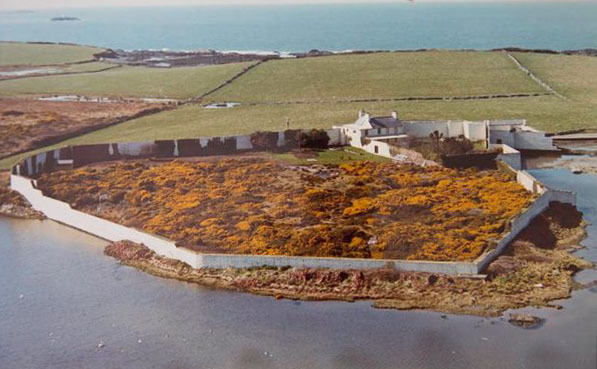
So what's behind the walls? Captain Hewitt wanted a garden, a big one in fact, 3 acres in size. He built the walls directly on foundations connected to the bedrock to stop burrowing rodents entering the gardens. He used about a million bricks to build walls generally 4 feet thick which contained a smaller lawned garden by the house and a rocky outer garden of about 2 acres. The walls kept out the winds and rats, a good thing for sea birds as rats do tend to pillage their eggs and a variety of other wildlife.
Captain Hewitt also introduced a weir across the Nant Cemlyn. next to Bryn Aber. This pivotal intervention reduced the tidal fluctuation in water level allowing the saltings to form perfect nesting sites for his beloved seabirds. So what you see when you visit Esgair Gemlyn is a beautiful natural shingle ridge formed by longshore drift, which in conjunction with a slight intervention by Hewitt with the weir, has created a perfect nature reserve.
Longshore Drift
Longshore Drift exists on most beaches and coastline because prevailing winds means the waves don't hit the shore in a straight line - they arrive at an angle. The waves may be carrying sediment so it will arrive onto the beach at an angle, the waves break on the shore and as the water runs back into the sea it carries the sediment back down the beach, perpendicular to the angle of the shoreline under the influence of gravity. This results in a zigzag motion as sediment is transported along the coastline.
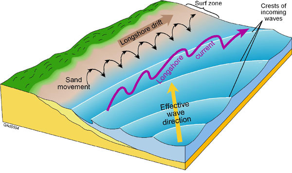
This process means that over time beaches can change shape. Sediment may be brought into some areas in quantity causing the beach to grow, equally it may be taken away so some beaches are at risk of disappearing as a consequence of longshore drift. This is why in many places groynes may be built to interrupt the flow of longshore drift, but inevitably some sand and gravel can escape. Longshore drift can form spits were the line of the coast changes sharply, for example at a river estuary. There are several examples of spits along the Welsh coastline.
Sometimes a spit can grow across a bay, and joins two headlands together. This landform is known as a bar and this is the proper name for the ridge we have here. Shallow lakes can be trapped behind them, and these are known as lagoons. Lagoons do not last forever and may be filled up with sediment.
Storms could put the ridge at risk as they have the capability to rise up over the ridge and move a lot of sediment in a very short space of time due to the increased power of the waves during these violent times. This could leave the ridge damaged or even breach it. The rising sea levels could effect the ridge in the future and there is talk of power station construction not far away. Therefore carefully management of the area is important.
So to summarise, here at Esgair Gemlyn the waves have deposited sediment over time and naturally created this hugely impressive ridge which has in turn allowed the nature reserve and lagoon to exist behind the ridge, where the sea and the bay used to be in the past. It is the hope this unique place will remain like this for the foreseeable future.
Questions to Answer (Logging Requirements)
All the information you need to answer the questions can be found in the listing and doesn't require any previous knowledge of geology. Please send in your answers before or soon after logging your find - I only ask you make a reasonable attempt. However, if no attempt at answers is made you risk your log being deleted. Answers can be sent via the message centre or the email facility on my profile. You do not need to wait for a reply, please log your find immediately. I try and reply as quickly as possible but there may be a delay at busy times.
Please do not be put off by the number of questions. I have given you the options so you only need to visit both reference points and choose from the options provided. Please read the lesson before making your judgement for question 7. It is recommended to avoid high tide (see above).
For this EarthCache you must imagine you are working for the National Trust as an intern advisor. They want to know if Longshore Drift is currently causing any threat to the ridge so they need you to make a number of observations by visiting at minimum both ends of the ridge (waypoints provided).
This can be achieved however you wish, I recommend the half mile walk across the ridge as it is very scenic and enjoyable but note any restrictions due to bird nesting (see above). However, there are car parks at both ends so you can drive fairly close to both stages quite easily. The waypoints are a little walk out onto the ridge as you won't get accurate answers if you are too close to the edge of the bay. In a perfect world I'd prefer you walked right across the ridge and considered these points throughout your walk but this is not mandatory - however, remember that as the make up of the ridge changes any potential weak points may alter a little so the waypoints are approximate.
1) Steepness Study. Choose either a, b, or c.
a) The ridge is steeper at Waypoint 1 (west) and more shallow at waypoint 2 (east)
b) The ridge is steeper at Waypoint 2 (east) and more shallow at waypoint 1 (west)
c) There is no significant difference in steepness at either end
2) Height Study. Ideally use an altimeter on your device (apps available). Choose either a, b, or c.
a) The ridge is higher at Waypoint 1 (west) and lower at waypoint 2 (east)
b) The ridge is higher at Waypoint 2 (east) and lower at waypoint 1 (west)
c) There is no significant difference in height at either end
3) Evidence Study. Can you see fresh rocks and sediment piling up close to where the waves are stopping at high tide? Growth of plants and sand or soil would be evidence of no material being currently despoisted. Choose either a, b, c or d.
a) There is evidence of fresh looking sediment at waypoint 1 (west)
b) There is evidence of fresh looking sediment at waypoint 2 (east)
c) There is fresh sediment to be seen at both ends
d) There is no fresh sediment at either end
4) Thickness Study. Look at the overall width of the ridge.Choose either a, b, or c.
a) The ridge is notably thinner around waypoint 1 (west) and thicker at waypoint 2 (east)
b) The ridge is notably thinner around waypoint 2 (east) and thicker at waypoint 1 (west)
c) About the same at both waypoints
Also look across the ridge as a whole, add an extra comment if you think there is another point of the ridge where it looks much thinner than anywhere else, as this may change over time.
5) Take a look at the stones on the ridge at waypoint 1 (west). (If you cannot access the ridge during the bird nest periods you should still be able to see from nearby vantage points.) Choose either a or b.
a) Stones are all mixed up with big and small stones together suggesting the ridge here has been altered by man and not created by waves
b) There are small stones close to the sea and the bigger stones are found on the top of the ridge, suggesting longshore drift is currently effecting the ridge here.
6) Take a look at the stones on the ridge at waypoint 2 (east). (If you cannot access the ridge during the bird nest periods you should still be able to see from nearby vantage points.) Choose either a or b.
a) Stones are all mixed up with big and small stones together suggesting the ridge here has been altered by man and not created by waves
b) There are small stones close to the sea and the bigger stones are found on the top of the ridge, suggesting longshore drift is currently effecting the ridge here.
7) Based on your answers to all of the above questions, do you foresee any risk to the ridge from the current longshore drift processes? Choose either a, b, c or d.
a) There is no risk to the ridge currently from longshore drift, it is depositing the sediment across the entire ridge evenly
b) There is a long term risk to the ridge. In many years the ridge may be at risk but there is no immediate threat
c) There is a medium term risk. Sediment is being moved along the ridge but there is no immediate risk and land management can compensate if and when needed
d) There is an immediate threat to the ridge. The land owner may need to consider intervention to ensure the nature reserve and lagoons are not compromised in the near future.
Please feel free to add any extra comment here about what you have observed and any weak points or dips in the ridge, these may alter (a storm for example could suddenly change the land significantly). Also, take a look at the coast west and east of the ridge. Add a comment about how the surrounding land may influence longshore drift here and whether this makes it more or less vulnerable.
8) A recent guideline change now allows photos to once again be a mandatory part of EarthCaches. Therefore, please include a photo of yourself/GPSr on the ridge but please try and avoid compromising the answers.
Thank you for visiting the Esgair Gemlyn EarthCache. I hope you enjoyed visiting this beautiful place.