The layers of Black cliff began their life as sediments during the Precambrian about 600-650MYA ago, after which they were folded and uplifted during the Delamerian Orogeny 500MYA to form the Mount Lofty ranges. A long period of erosion occurred leaving a gap of some 220MY in the geological history or the area.
As Permian times arose, a great ice sheet covered Gondwana of which Australia was a part. The glacier flowed over southern Australia in a northwesterly direction, lasting a few million years before melting. Slowly the glacier moved over the landscape cutting its way through mountains and plains alike.
The glacier left evidence of its movement on the rocks found in Hallett Cove Conservation Park. As the glacier moved forward, melt below the glacier containing small gains of sand and rock worked together, slowly grinding and polishing the surface below. This form of erosion is known to geologists as basal sliding and is associated with wet-bottomed glaciers.
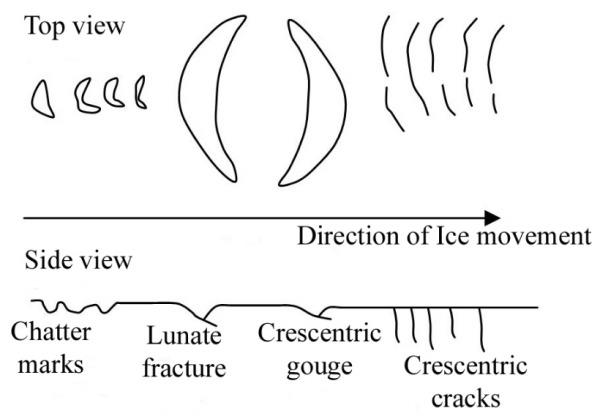
Larger rocks and stones within and under the glacier’s base gouge stratch lines, chatter marks and grooves as they were carried across rock surfaces. It is these marks that help us to determine the travel direction of the glacier. Geologists call these marks glacial striations.
At the listed coordinates you can see a world famous flat polished rock surface showing evidence of glacial erosion. The rock surface polished by basal sliding also has scratches, and chatter marks suggesting North-West direction of glacier travel. The presence in the area of erratic boulders from areas to the South-East confirm the glacier movement direction.
From the view point on the trail please inspect the rock and answer the following questions. Send your answers to the cache owner by email or message.
- Describe the colour and texture of the rock surface?
- What is the longest feature on the rock surface? Why is that feature present?