Che cos'è lo gneiss?
Lo gneiss o gneis, dal tedesco Gneis è una delle più comuni rocce metamorfiche costituenti la crosta continentale. 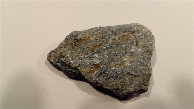 È il risultato del metamorfismo regionale dinamotermico di rocce originarie (protoliti) di composizione sialica, ovvero ricche di quarzo e feldspati e povere di silicati ferro-magnesiaci. Si forma a grande profondità, per effetto delle mutate condizioni di pressione e temperatura, nelle zone di convergenza di due placche, durante la fase di subduzione e in quella successiva di collisione continentale, che danno origine alle catene montuose. Il termine «gneiss» nacque alla fine del '700 per indicare una roccia che aveva dei minerali orientati lungo piani e che conteneva abbondanti feldspati. In seguito il termine è stato utilizzato con significato strutturale. Per molto tempo i geologi hanno indicato con questo nome tutte le rocce metamorfiche con una particolare tessitura, nella quale la foliazione metamorfica è caratterizzata da un'alternanza di sottili letti ricchi in minerali lamellari – miche e cloriti in prevalenza – e letti molto più spessi formati in prevalenza da minerali granulari sialici – quarzo con uno o più feldspati.
Piega geologia

In ambito geologico viene definita piega una deformazione duttile di masse rocciose nella quale delle superfici, in origine planari, vengono piegate o curvate. Queste possono essere strati delle rocce sedimentarie, foliazioni metamorfiche o layering (alternanze nella roccia di livelli di differente composizione mineralogica). Solitamente le pieghe sono il risultato di forze compressive agenti in modo non omogeneo entro la massa rocciosa e tali da determinarne un comportamento duttile, ossia una deformazione plastica (cioè permanente) e continua (senza rotture). 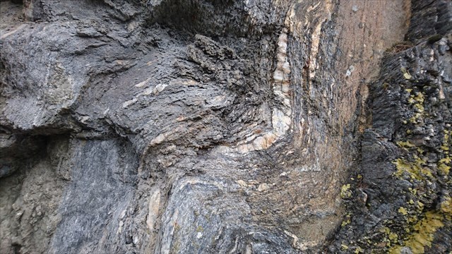 Tale comportamento delle rocce è favorito da elevate temperature e/o pressioni litostatiche. Per questo i piegamenti avvengono in genere ad una certa profondità nel sottosuolo, mentre in superficie prevalgono comportamenti fragili (faglie e fratture). Il piegamento superficiale può avvenire quando le forze sono di debole intensità e la loro azione è diluita nel tempo oppure quando la deformazione interessa sedimenti non ancora litificati. in quest'ultimo caso si parla di pieghe sinsedimentarie. La grandezza di una piega può essere molto variabile, da millimetrica, alla scala dell'affioramento, fino a pieghe di grandezza chilometrica o pluri-chilometrica nel caso di catene montuose.
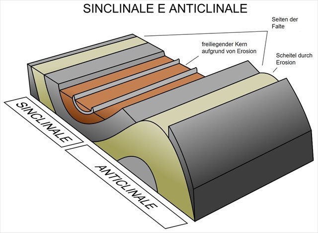
Anticlinale
In geologia, una anticlinale è una piega degli strati rocciosi, con gli strati più antichi posizionati al nucleo; essa è il risultato degli sforzi compressivi o tangenziali a cui sono state sottoposte le rocce nel corso del tempo, che le ha deformate plasticamente.
Sinclinale
La sinclinale in geologia è una piega in cui la curvatura di strati rocciosi presenta normalmente la convessità orientata verso il basso, nel suo nucleo si trovano rocce più giovani rispetto a quelle degli strati esterni. Da notare che in affioramento, causa l'erosione, gli strati stratigraficamente più antichi si trovano all'esterno del nucleo della sinclinale, sui due fianchi della struttura mentre quelli più recenti si trovano all'interno, nel nucleo.
Monoclinale
Una monoclinale è una piega a gradino (detta step-like fold) in strati rocciosi composta da una zona di maggiore inclinazione all'interno di una successione poco inclinata o suborizzontale.
Per loggare questa Earthcache, andate alle coordinate indicate e rispondete alle seguenti domande. Inoltre, dovrete pubblicare con il log una vostra foto sul posto. Ovviamente, se non si vuole apparire nella foto, un oggetto personale è una prova sufficiente della vostra presenza. (Secondo le linee guida delle Earthcache, è possibile richiedereil fotolog dal giugno 2019.)
1.) Dai un'occhiata da vicino allo gneiss. Descrivi la durezza, la struttura e la granulosità. (Nota: Le linee bianche sono al quarzo e non gneiss.)
2.) Come sono allineate le pieghe? Sono orizzontali o verticali? Pensa a cosa è successo qui, fino a quando la roccia non ha raggiunto questa forma in questa situazione.
3.) Quali tipi di pieghe si possono scoprire su questo muro?
Puoi loggare immediatamente. Se qualcosa non è corretto, ti contatterò.

Was ist Gneis?
Gneis oder Gneis, aus dem deutschen Gneis, ist eines der häufigsten metamorphen Gesteine der Kontinentalkruste. Es ist das Ergebnis der dynamothermischen regionalen Metamorphose von ursprünglichen Gesteinen (Protolithen) mit sialischer Zusammensetzung, die reich an Quarz und Feldspat und arm an Ferro-Magnesium-Silikaten sind. Aufgrund der veränderten Druck- und Temperaturbedingungen bildet es sich in großer Tiefe in den Konvergenzzonen zweier Platten, während der Subduktionsphase und bei der anschließenden Kontinentalkollision, die die Gebirgsketten entstehen lässt. Der Begriff "Gneis" wurde Ende des 18. Jahrhunderts geboren, um ein Gestein zu bezeichnen, dessen Mineralien sich an Ebenen orientierten und das reichlich Feldspäte enthielt. Später wurde der Begriff mit struktureller Bedeutung verwendet. Seit langer Zeit haben Geologen unter diesem Namen alle metamorphen Gesteine mit einer bestimmten Textur identifiziert, bei der die metamorphe Blattbildung durch eine Abwechslung dünner Schichten gekennzeichnet ist, die reich an lamellaren Mineralien sind - Glimmer und Chlorite -. und viel dickere Schichten, die hauptsächlich aus sialischen körnigen Mineralien bestehen - Quarz mit einem oder mehreren Feldspaten.
Geologische Falte
Unter einer duktilen Verformung von Gesteinsmassen wird geologisch eine Biegung verstanden, in der ursprünglich ebene Flächen gebogen oder gekrümmt sind. Dies können Schichten von Sedimentgesteinen, metamorphe Schichtung oder Schichtung sein (Gesteinswechsel mit Gehalten unterschiedlicher mineralogischer Zusammensetzung). Normalerweise sind die Falten das Ergebnis von Druckkräften, die ungleichmäßig in der Gesteinsmasse wirken und so ein duktiles Verhalten bestimmen, das heißt ein plastisches (permanentes) und ein kontinuierliches (ohne Brüche) Verhalten. Ein solches Verhalten von Gesteinen wird durch hohe Temperaturen und / oder lithostatischen Druck begünstigt. Aus diesem Grund kommt es in der Regel ab einer bestimmten Tiefe im Untergrund zu Biegungen, während an der Oberfläche fragiles Verhalten vorherrscht (Verwerfungen und Brüche). Eine Oberflächenbiegung kann auftreten, wenn die Kräfte schwach sind und ihre Wirkung mit der Zeit nachlässt oder wenn die Verformung Sedimente betrifft, die noch nicht lithifiziert wurden. im letzteren Fall spricht man von Syndikularfalten. Die Größe einer Falte kann sehr unterschiedlich sein, von Millimeter bis zum Aufschlussmaßstab, bis hin zu Kilometerfalten oder mehreren Kilometern bei Gebirgszügen.
Antiklinale
In der Geologie ist ein Anticline eine Falte der felsigen Schichten, wobei die ältesten Schichten im Kern positioniert sind; es ist das Ergebnis der Druck- oder Tangentialbemühungen, denen die Gesteine im Laufe der Zeit ausgesetzt waren und die sie plastisch deformiert haben.
Synklinale
Die Synkline in der Geologie ist eine Falte, in der die Krümmung der Gesteinsschichten normalerweise die nach unten gerichtete Konvexität zeigt, in ihrem Kern befinden sich Gesteine, die jünger sind als die der äußeren Schichten. Beachten Sie, dass sich beim Aufschluss aufgrund der Erosion die stratigraphisch ältesten Schichten außerhalb des Kerns der Synklinale auf den beiden Seiten der Struktur befinden, während sich die neueren Schichten innerhalb des Kerns befinden.
Monoklinale
Eine Monoklinale ist eine Stufenfalte (als Stufenfalte bezeichnet) in Gesteinsschichten, die sich aus einem Bereich größerer Neigung in einer leicht geneigten oder subhorizontalen Folge zusammensetzt.
Um diesen Earthcache zu loggen, begib dich zu dieser Location und beantworte nachfolgende Fragen. Anschließend postet zu eurem Log bitte noch ein Foto von euch an der Location. Wenn ihr selbst nicht auf dem Foto erscheinen wollt, reicht natürlich auch ein persönlicher Gegenstand auf dem Foto als Beweis eurer Anwesenheit. (Laut Earthcache Guidelines ist die Forderung eines Fotobeweises seit Juni 2019 wieder erlaubt.)
1.) Sieh dir den Gneis einmal genau an. Beschreibe die Festigkeit, Struktur, und Körnung. ( Beachte dabei: Die weißen Adern sind Quarz und kein Gneis.)
2.) Wie sind die Falten ausgerichtet? Liegen sie horizontal oder vertikal? Überlege was hier geschehen ist, bis das Gestein diese Form in dieser Lage erreicht hat.
3.) Welche Arten von Falten kannst du an dieser Wand entdecken?
Danach könnt Ihr sofort loggen. Wenn irgendetwas nicht in Ordnung sein sollte, melde ich mich.

What is Gneiss?
Gneiss or gneis, from the German gneis, is one of the most frequent metamorphic rocks of the continental crust. Graph It is the result of dynamothermic regional metamorphosis of primitive rocks (protoliths) with sialic composition rich in quartz and feldspar and low in ferro-magnesium Silicates are. Due to the changing pressure and temperature conditions, it forms at great depth in the convergence zones of two plates, during the subduction phase and during the subsequent continental collision, which gives rise to the mountain ranges. The term "gneiss" was born at the end of the 18th century to refer to a rock whose minerals were oriented at levels and contained abundant feldspars. Later, the term was used with structural meaning. For a long time geologists have identified under this name all metamorphic rocks with a specific texture, in which metamorphic foliation is characterized by a variation of thin layers rich in lamellar minerals - mica and chlorite -. and much thicker layers consisting mainly of sialic granular minerals - quartz with one or more feldspar.
Geological fold

By a ductile deformation of rock masses is meant geologically a bend in which originally flat surfaces are bent or curved. These can be layers of sedimentary rocks, metamorphic stratification or stratification (rock changes with contents of different mineralogical composition). Normally, wrinkles are the result of compressive forces acting unevenly in the mass of rock, thus determining ductile behavior, that is, plastic (permanent) and continuous (non-fractured) behavior. Such behavior of rocks is favored by high temperatures and / or lithostatic pressure. For this reason, bends usually occur at a certain depth in the ground, whereas fragile behavior prevails on the surface (distortions and fractures). Surface bending can occur when the forces are weak and their effect diminishes over time, or when the deformation affects sediments that have not yet been lithiated. in the latter case we speak of syndical folds. The size of a crease can be very different, from millimeters to the pulping scale, up to kilometer folds or several kilometers in mountain ranges.
Anticline
In geology, an anticline is a fold of rocky strata, with the oldest strata positioned in the core; it is the result of the pressure or tangential efforts to which the rocks have been exposed over time and which have plastically deformed them.
Synclinal
The syncline in geology is a crease in which the curvature of the rock strata usually shows downward convexity, at its core are rocks younger than those of the outer strata The erosion of the stratigraphically oldest strata is located outside the nucleus of the syncline on both sides of the structure, while the newer strata reside within the nucleus.
Monoclinal
A monoclinic is a step fold (referred to as a step fold) in rock strata that is composed of a region of greater inclination in a slightly inclined or subhorizontal sequence.
To log this Earthcache, go to this location and answer the following questions. Then post a photo of you at the location to your log. Of course, if you do not want to appear in the photo, a personal item in the photo is enough proof of your presence. (According to the Earthcache Guidelines, photo-proofing has been required since June 2019.)
1.) Take a close look at the gneiss. Describe the strength, structure, and grain. (Note: The white wires are quartz and not gneiss.)
2.) How are the wrinkles aligned? Are they horizontal or vertical? Think about what happened here, until the rock has reached this shape in this situation.
3.) What types of folds can you discover on this wall?
After that you can give your log directly. If anything is not ok, i will contact you.
l'indice delle fonti:
· Wikipedia
· Fotos intrinsecamente