Welcome to another church micro in the popular national series. Here we visit the Roman Catholic church of St. Mary's in Stockport. This is an EarthCache, there are a couple of waypoints but they are very close together, only a minute or so to walk between each one, so don't be put off. However, you should allow a short time here to walk around, look at the sandstone and gather your answers.
Anyone who has driven through Stockport on the M60 can't help but notice the church of St. Mary stood up on the clifftop overlooking the motorway. It is particularly dramatic as it sits on the edge of a sandstone escarpment with the motorway running below. The church enjoys an elevated position at the top of this sandstone cliff, and beautiful old paths and roads cut into the rock lead up to the church giving you the opportunity to see close up the stone beneath the church of St. Mary.
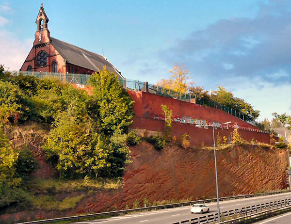
St Mary's Roman Catholic Church on Dodge Hill was designed by Pugin & Pugin, 1897 and is a prominent local landmark. It is constructed of red brick with stone dressings and window tracery and a slate roof. The west front has a tall gabled bell cote on a stepped base beneath which is a statue of the Virgin and Child. Stepped buttresses framing a large rose window are flanked by traceried windows with paired lights. Photo © Gerald England (cc-by-sa/2.0)
Logging Requirements
This EarthCache follows a slightly different format where you will read a paragraph of information and then it will be immediately followed by a question on that particular topic. Therefore the questions are intermingled with the information to make it easy to follow, they are not all listed at the end. There are five questions, they aren't hard and I have broken them down so you can make a few notes on each topic quite quickly. The sixth question is a photo only. You should find this EarthCache is actually really easy and gives you an nice overview of a few characteristics of sandstone.
The listed coordinates are for the recommended parking, there are no questions at the listed coordinates, the questions are at the waypoints which are really close to the parking. The waypoints are extremely close together, they are only given to guide you to exactly the right bit of rock. No previous geological knowledge is required, all the information is included in the listing so you can see and learn. Please send in the answers to the five questions via my profile, either using message center or email. Remember you need good signal to use the 'send message' option in the app. Please send answers when you log, or soon afterwards. If no answers are received you risk your log being deleted.
I have marked it as wheelchair accessible but it may be wise to have someone with you, noting the following points. The path from the parking has a zig zag ramp and there are pavements to all the cliff locations. Please note to get to the church for the photo it is a narrow road with no pavement and uphill. Some of the road is cobbled but you should be able to avoid the cobbles.
Sandstone
Stockport stands on Permian sandstones and red Triassic sandstones and mudstones, mantled by thick deposits of till and pockets of sand and gravel deposited by glaciers at the end of the last glacial period, some 15,000 years ago. To the extreme east is the Red Rock fault, and the older rocks from the Upper Carboniferous period surface.
Sandstone is one of the most common types of sedimentary rock found in the world. Sedimentary rocks can be formed from particles of sand, shells, pebbles, and other fragments of material. Together, all these particles are called sediment. Gradually, the sediment accumulates in layers and over a long period of time hardens into rock. An example might be millions of years ago a flood caused a layer of sand to be deposited. This might create one layer of the rock you see here. Then maybe a few years or many years later another flood left another layer of sand. Again, another layer is created. This process continued for millions of years, the lower layers gradually getting squeezed more and more by the heavy deposits above them. The thickness of the layer is determined by the amount of sediment deposited, therefore a bigger and longer flood would deposit more sediment creating a thicker layer
Sandstone can be found in a range of varying colours, all dependent on the composite materials and where they originate from. As these grains are deposited by air or water the origins of such grains can be from very different geological locations and produce many natural tonal variations and/or exquisite natural veining. For example, if the sandstone contains silica and calcium carbonate it would give the rock a yellow colour. Another ingredient might be iron oxide, which gives the sandstone reddish tints ranging from pink to dark red (terracotta). If manganese is present this would provide the sandstone with a purplish hue. There are other colour tones sandstone might gain but they aren't relevant to this particular location.
Question 1 - see waypoints for question 1 and 4
Firstly you need to have a close look at the rock. Yes, this comes up a lot on EarthCaches but it is important for you to look at the basic properties of the stone. Very briefly describe the rock, noting the following points
How big are the grains?
How smooth is it to touch?
How hard do you think it is given the erosion you can see here?
What is the colour of the rock and what ingredient has caused this colour in the stone?
Beds or Layers in Sandstone
Sandstone is formed in layers, or beds. Bedding in sandstones, may be tens of feet thick, but it can range downward to paper-thin layers. Thin, nearly horizontal lamination is characteristic of many ancient beach sandstones. Sediment would build up over a long period of time but some event would occur causing the sediment to stop forming for a time. Sediments are transported only when there is enough energy in the transporting medium, for example, when a stream is flowing rapidly enough to carry a given size of sedimentary particle. A lake might freeze over in the winter and all the sediment settles. Sediment might form in the bottom of a lake until there is a drought and the lake dries up. Later, the water returns and the sediment would start to form again but it would form a different bed or layer when it resumes and these beds are clearly visible here.
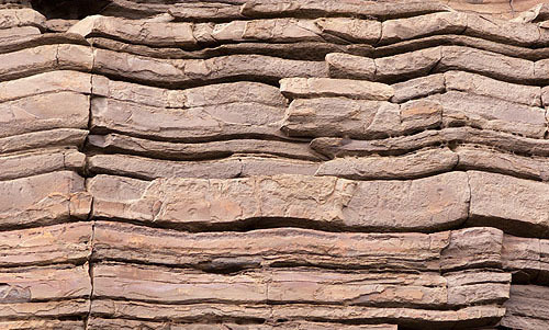
If the rock was formed by a fairly regular geological cycle we might expect all the layers to be similar thicknesses, where as if the formation cycle was interrupted more irregularly the layers might have more random thicknesses.
When the stone was formed the original layers would have been horizontal due to gravity naturally dropping the sediment to the bottom of the sea or the lake. If the layers are not horizontal, the rock has been moved and tilted during powerful geological events after the rock was formed.
Question 2 - see waypoints for question 2/3
Looking at the sandstone facing the road, describe the main layers. These are easy to see as they have clear gaps between them.
How many distinct layers can you see?
Are all the layers the same thickness and what would you say is the average height?
Are they horizontal, if not, what angle are they?
What does the layer thickness tell you about the regularity of the geological formation cycle when this rock was formed?
Cross Bedding in Sandstone
In geology, cross-bedding is layering within a rock but at an angle to the main bedding plane. The sedimentary structures which result are roughly horizontal units composed of inclined layers. As explained above, sedimentary rocks always form horizontal layers due to gravity, but what happens if the surface those layers are forming on is itself not flat?
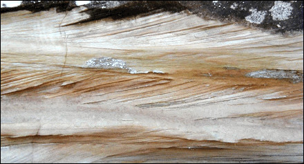
If this sandstone was deposited on a nearly flat plane, but the beds below were laid down on a sloping surface, you end up with cross bedding - it looks rather like brush strokes going one way and then another way on a canvas. The cross bedding may reflect the steep faces down which sediment tumbles during current transport. In a river, cross bedding may help to show which direction water was flowing. Cross-beds can tell geologists much about what an area was like in ancient times but it is quite a complex topic so we won't go into any more detail in this EarthCache.
Question 3 - same waypoint as previous question
Look at the cross bedding in the cliff here. There are some regular cuts at the bottom of the cliff in the rock near the brick work which are likely man made, please look higher up for the natural cross bedding which is clear to see across most of the cliff face.
Roughly what angle is the cross bedding compared to the main beds?
Are the beds tilting down or up towards Stockport centre?
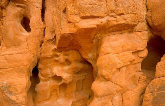
Foreign Stones in the Sandstone
At both the first two waypoints it is quite interesting that you will find clearly visible stones in the rock face that are not sandstone. In this type of sandstone, you can find medium-grained conglomerates or pebbly sandstones and coarse-grained sandstones. If you were to find smooth pebbles in the rock here then you would know that the stone forming these pebbles has been transported by river or sea, and over time eroded and worn away by water to the size you find it here today. If the stones you found had harder edges, you would know they had not been transported in the same way by water. The stones here have not been eroded down to the particle size of the sandstone grains and is therefore they are not part of the sandstone - something occurred during the rock formation process to allow these stones to become wedged into the stone. If the stones are made of something very hard like quartz, it would be clear these pebbles were a very different rock type to the sandstone. Quartz is an ingredient of sandstone, but you wouldn't expect to find it in visible form. We won't look at this in any further detail but it is interesting to stop and have a look.
Question 4 - see waypoints for question 1 and 4
Describe the foreign stones in the sandstone.
Are the foreign stones pebbles, e.g. are they smooth or sharp edged and what does this tell you about how the stones has eroded?
Are all the foreign stones the same type of stone or do they vary?
What is the approximate size of the biggest bit of foreign stone you see?
What is the approximate size of the smallest bit of foreign stone you see?
Question 5 - see waypoints for question 5
You are now standing directly under the church. Consider the same observations from question 1. We are interested to see if this sandstone is identical to the nearby sandstone edge you just studied, as you would perhaps assume it would be as it is extremely close.
Note any differences here between what you noted in question 1 and here. Consider colour, texture, layers, cross bedding and pebble content. Only a sentence or two is needed, no essays required!
Question 6 - Photo - see waypoints for question 6
Under revised EarthCaching guidelines, it is a logging requirement to take a photograph of yourself/personal object/GPSr. This being a church micro, please take a photo with the church in the background at the final waypoint and attach it to your log. Please note the church is above parking area, note the waypoint. It is not the obvious church building close to the parking.
Thank you for visiting the EarthCache for St. Mary's RC Church
****************** ********************
For full information on how you can expand the Church Micro series by sadexploration please read the Place your own Church Micro page before you contact him at churchmicro.co.uk
See also the Church Micro Statistics and Home pages for further information about the series.
****************** *******************