 Résultant de l'altération et de l'érosion des premiers reliefs de la chaîne cadomienne, les sédiments à l'origine des roches qui affleurent à la pointe de Grainfollet se sont d'abord déposés dans un bassin marin il y a quelques 600 millions d'années. Par la suite, entre 600 et 540 millions d'années, ces sédiments déjà indurés se sont retrouvés enfouis dans les profondeurs de l'écorce terrestre et ont alors été soumis à des températures et des pressions élevées qui ont considérablement modifié leur structure interne. Ces roches ont été métamorphisées.
Affleurant en petite falaise, ces roches grisâtres à beiges, sont constituées d'un assemblage minéralogique de quartz, de feldspath, de chlorite et de micas (biotite et muscovite). Elles sont déformées et montrent de nombreux plis décimétriques à métriques.
Le litage sédimentaire initial est bien reconnaissable, souligné par l'alternance de niveaux à grain grossier et de niveaux fins. Les niveaux grossiers correspondent à des gneiss fins qui résultent du métamorphisme de roches gréseuses tandis que les niveaux fins, qui sont des micaschistes, dérivent de sédiments vaseux ou argileux.
Rappel géologique
Un pli est une structure courbe due à une déformation ductile de la roche sous l'effet d'une contrainte compressive. La connaissance de la forme avant la déformation permet de la quantifier. Le cas le plus simple est le pli de roches sédimentaires, dont la structure et les marqueurs sont planaires avant la déformation.
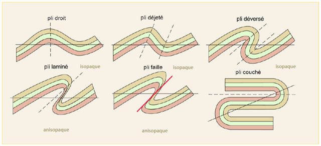
L’attitude du plan axial dans l’espace permet de décrire la géométrie d’ensemble du pli. Si l’épaisseur des couches est conservée durant la déformation, le pli est dit isopaque (même épaisseur.)
Pour caractériser totalement la forme d’un pli on ajoute à ce critère d’inclinaison, la notion d’étirement (ou laminage) des flancs pouvant conduire à la rupture de la continuité des couches entre deux axes de plis. Un pli dont les flancs sont étirés est dit anisopaque.
Ainsi, le pli laminé est un pli déversé anisopaque. Le pli faille est un pli laminé dont l’étirement extrême des couches dans le plan axial a conduit à la rupture. Il en résulte l’apparition d’une faille inverse, d’où le terme de pli faille.
Lorsqu'on est en présence d'un ensemble de plis, on appelle antiforme un pli dont la convexité est tournée vers le haut (il forme une bosse). Le pli dont la convexité est tournée vers le bas (il forme un creux) est appelé synforme.
 Resulting from the alteration and erosion of the first reefs of the Cadomian chain, the sediments at the origin of the rocks that are outcropping at the Grainfollet point were first deposited in a marine basin some 600 million years ago. years. Subsequently, between 600 and 540 million years ago, these already indurated sediments were buried in the depths of the Earth's crust and were then subjected to high temperatures and pressures that significantly altered their internal structure. These rocks have been metamorphosed.
These gray-to-beige rocks, flush with cliffs, consist of a mineralogical assemblage of quartz, feldspar, chlorite and micas (biotite and muscovite). They are distorted and show many decimetric to metric folds.
The initial sedimentary bedding is well recognizable, underlined by the alternation of coarse-grained levels and fine levels. The coarse levels are fine gneisses resulting from the metamorphism of sandstone rocks while the fine levels, which are micaschists, derive from muddy or clayey sediments.
Geological reminder
A fold is a curved structure due to a ductile deformation of the rock under the effect of a compressive stress. The knowledge of the shape before the deformation makes it possible to quantify it. The simplest case is the fold of sedimentary rocks, whose structure and markers are planar before deformation.
The attitude of the axial plane in space makes it possible to describe the overall geometry of the fold. If the thickness of the layers is preserved during the deformation, the fold is called isopaque (same thickness.)
To completely characterize the shape of a fold is added to this tilt criterion, the notion of stretching (or rolling) flanks may lead to the rupture of the continuity of the layers between two fold axes. A fold whose flanks are stretched is called anisopaque.
Thus, the laminated fold is an anisopaque spill. The fold fold is a laminated fold whose extreme stretching of the layers in the axial plane has led to rupture. This results in the appearance of a reverse fault, hence the term fold fault.
When one is in the presence of a set of folds, one calls antiform a fold whose convexity is turned towards the top (it forms a hump). The fold whose convexity is turned down (it forms a hollow) is called synform.
!!! ATTENTION CACHE INACCESSIBLE A MAREE HAUTE !!!
!!! WARNING EARTHCACHE INACCESSIBLE HIGH TIDE !!!
Avant de vous y aventurer, consulter l'horaire des marées sur la Rance:
Before you go, check the tide schedule on the Rance river :
Horaires des marées en Rance
Questions pour valider cette earthcache :
D'après vos observations et à l'aide du descriptif :
Questions to validate this earthcache:
Based on your observations and using the description :
Question 0
Joindre à votre log une photo de vous, votre GPS, votre GC perso ou tout autre objet vous représentant dans le jeu aux coordonnées de la cache (sans montrer les réponses !)
Attach to your log a photo of you, your GPS, your personal GC or any other object representing you in the game at the posted coordinates (without showing the answers !)
Stage 1
Question 1
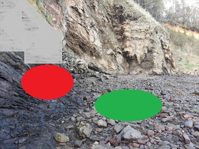
a. Quel type de pli peut-on observer sous la zone rouge ?
a. What type of fold can we observe under the red zone ?
b. Quel est son ordre de grandeur ? Centimétrique, décimétrique ou métrique ?
b. What is his order of magnitude ? Centrimetric, decimetric or metric ?
Question 2
Combien de synforme(s) présente le pli sous la zone verte ?
How many synform(s) has the fold under the green zone?
Stage 2
Question 3
Quel type de pli peut-on observer sous la zone violette ?
What type of fold can we observe under the purple zone ?
Envoyez-moi vos propositions de réponses soit via mon profil, soit via la messagerie geocaching.com (Message Center) PUIS loguez cette cache "Found it", je vous contacterai en cas de problème.
Assurez vous de répondre à TOUTES les questions ! La condition principale pour loguer une Earthcache étant de répondre aux questions posées dans le descriptif, tout log "Found it" enregistré sans envoi préalable de vos propositions de réponses sera supprimé. Il en sera de même pour les logs enregistrés sans la photo requise.
Send me your proposals for answers either via my profile or via the geocaching.com messaging (Message Center) THEN log this cache "Found it", I will contact you in case of problem.
Make sure to answer ALL questions ! The main condition to log an Earthcache is to answer the questions asked in the description, any log "Found it" registered without prior submission of your proposals of answers will be deleted. It will be the same for logs saved without the required photo.