El Teide
Attention: To be allowed to climb the summit of El Teide, you have to book a permit online. Make sure that you make a reservation beforehand. Click here. Staying overnight at the Refugio de Altavista allows you to reach the summit before 9 a.m. For more information, click here.
Achtung: Um den Gipfel des Teide zu besteigen, braucht ihr eine Genehmigung. Die Reservierung kostet nichts und muss im Vorfeld gebucht werden. Klickt dazu hier. Alternativ könnt ihr auch im Refugio del Teide übernachten und vor 9 Uhr morgens ohne Genehmigung auf den Gipfel steigen. Mehr Informationen erhaltet ihr hier.
Attention!: Necesitdas un permiso para poder subir a la cumbre del Teide. Asegúrate de organizarlo de antemano. Para más información, haga clic aquí. Puedes pasar la noche en el Refugio de Altavista y subir a la cima sin un permiso antes de las 9 de la mañana. Más información se puede encontrar aquí.
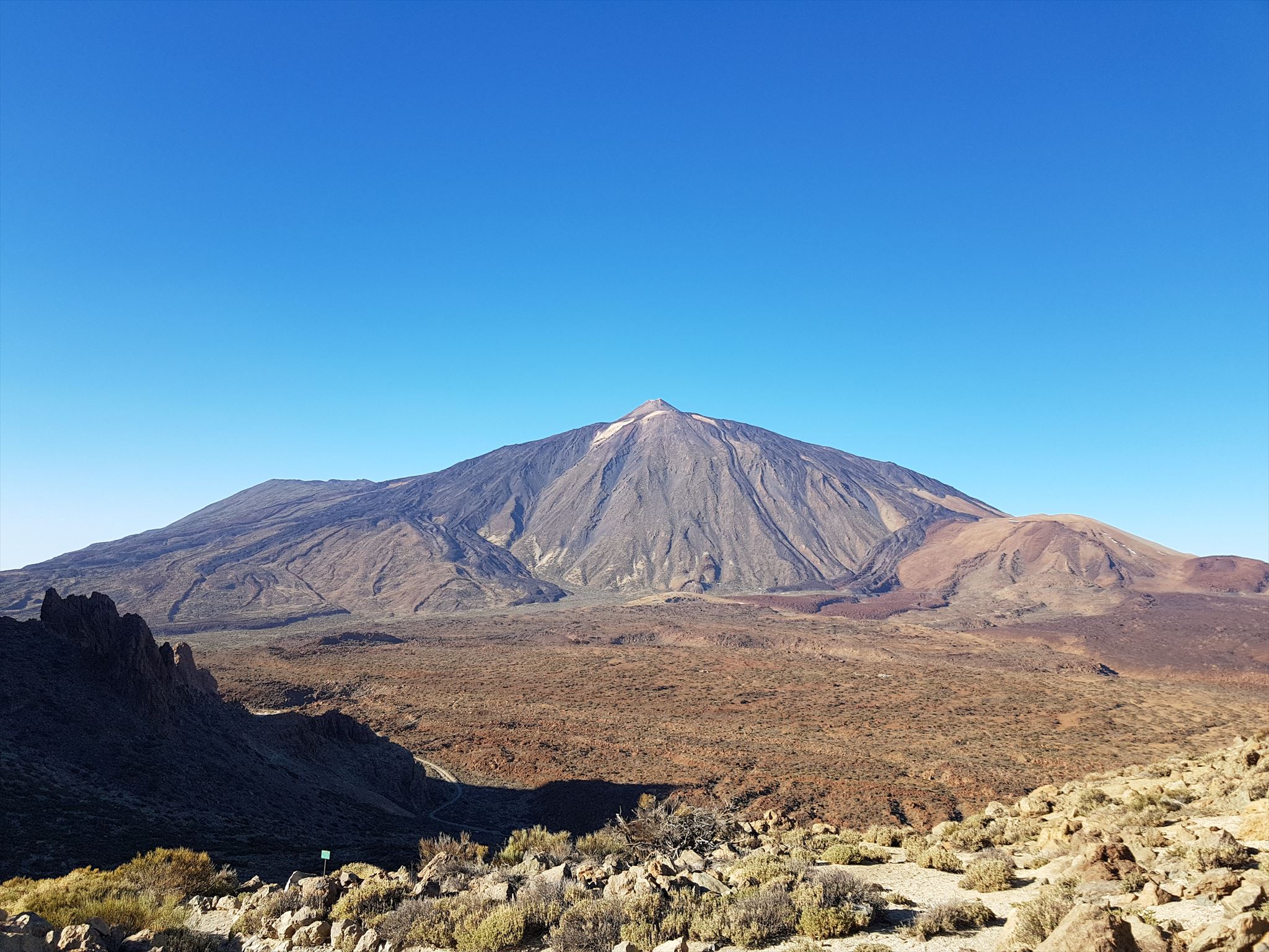
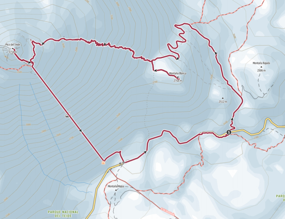
ENG: This multi cache was hidden bei Co90 and me on New Year's Day 2020. We were looking forward to climbing the Teide for a couple of weeks already and were stunned by the amazing landscape on our way to the top. Your task is the following: Follow the Pista Montaña Blanca, walk past the Field of Teide Eggs and take a short detour to the top of Montaña Blanca. After that, you just have to follow Sendero 7. You can stop for a short break or spend the night at the Refugio de Altavista before you continue your hike to the Mirador El Fortaleza and follow the Sendero 11 to the checkpoint. There you have to show your summit permit. You have to organize it beforehand, but it is for free. Make sure that you stick to the time slot that you have booked. Follow Sendero 10 to the top of El Teide and enjoy the views from up there. When you get there, you will have climbed the highest mountain in Spain! After that, it is up to you whether you would like to take the same route down or take the cable car as suggested in the following map. The final of the multi cache is roughly on the way back to the parking lot at the listed coordinates. Your route leads you through the Parque Nacional del Teide. Don't leave the marked paths - all the waypoints can be found right on the path.
DEU: Dieser Multi wurde von Co90 und mir am Neujahrstag 2020 versteckt. Seit Wochen fieberten wir dem Aufstieg auf den Teide entgegen und nun war es endlich soweit. Die Aussichten waren beeindruckend und wir kamen ganz schön ins Schnaufen. Die Luft wird doch recht dünn auf dem Weg nach oben. Eure Aufgabe ist einfach. Startet am Parkplatz an der TF-21 und folgt der Pista Montaña Blanca. Ihr kommt auf dem Weg an den Huevos/ Teide Eiern vorbei. Macht einen kleinen Abstecher zum Gipfel des Montaña Blanca. Danach geht es auf dem Sendero 7 steil hinauf zum Refugio Altavista. Hier könnt ihr eine Verschnaufpause einlegen oder auch übernachten. Informiert euch einfach online, was die Buchungsbedingungen betrifft. Von hier aus geht es weiter bis zum Aussichtspunkt El Fortaleza und vorbei an den ersten Fumarolas. Über den Sendero 11 kommt ihr dann zum Kontrollhäuschen, wo ihr euer Gipfelpermit vorzeigen müsst. Dieses ist kostenlos, aber ihr müsst im Vorfeld einen konkreten Zeitslot buchen. Stellt sicher, dass ihr rechtzeitig da seid. Von hier geht es über den Sendero 10 zum Gipfel des Teide. Genießt die Aussicht, atmet tief ein und genießt die Schwefeldämpfe ;-). Wenn ihr hier angekommen seid, habt ihr den höchsten Berg Spaniens bezwungen. Wie ihr dann wieder nach unten kommt, ist euch überlassen. Wenn ihr sportlich seid, könnt ihr die gleiche Route wieder hinabsteigen. Ihr könnt aber auch die Seilbahn hinunter nehmen. Das Finale befindet sich in der Nähe der TF-21 auf dem Weg zurück zum Ausgangspunkt. Errechnet das Final am besten direkt auf dem Gipfel, dann habt ihr eine Orientierung. Die gesamte Route führt euch durch den Parque Nacional del Teide. Verlasst zu keinem Zeitpunkt die markierten Wege - alle Wegpunkte liegen direkt am Pfad.
ESP: Este caché múltiple estaba oculto entre Co90 y yo el día de Año Nuevo 2020. Teníamos muchas ganas de escalar el Teide durante un par de semanas y nos sorprendió el increíble paisaje en nuestro camino hacia la cima. Su tarea es la siguiente: siga la Pista Montaña Blanca, pase el campo de huevos del Teide y tome un pequeño desvío hasta la cima de Montaña Blanca. Después de eso, solo tiene que seguir a Sendero 7. Puede detenerse para un breve descanso o pasar la noche en el Refugio de Altavista antes de continuar su caminata hacia el Mirador El Fortaleza y seguir el Sendero 11 hasta el puesto de control. Ahí tienes que mostrar tu permiso de cumbre. Tienes que organizarlo de antemano, pero es gratis. Asegúrese de cumplir con el horario que ha reservado. Siga Sendero 10 hasta la cima de El Teide y disfrute de las vistas desde allí. ¡Cuando llegues allí, habrás escalado la montaña más alta de España! Después de eso, depende de usted si desea tomar la misma ruta o tomar el teleférico como se sugiere en el siguiente mapa. El final de la caché múltiple está aproximadamente de regreso al estacionamiento en las coordenadas enumeradas. Tu ruta te lleva por el Parque Nacional del Teide. No deje las rutas marcadas: todos los puntos de ruta se pueden encontrar directamente en la ruta.
Start (N 28° 15.566 W 16° 36.208)
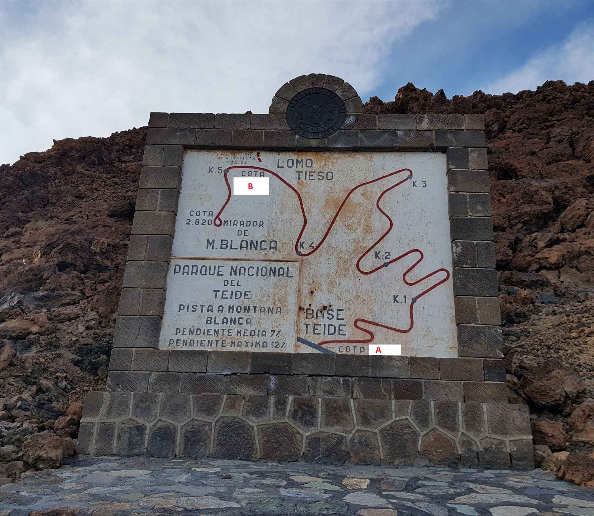
Find the monument near the listed coordinates. Take note of the heights that are missing in the following picture as A and B.
Finde das Denkmal nahe den Listingkoordinaten. Notiert euch die Höhenmeter, die im folgenden Bild fehlen als A und B.
Enduentra el monument cerca de las coordenadas enumeradas. Tome nota de las alturas que faltan en la siguiente imagen como A y B.
Stage 1 (N 28° 16.241 W 16° 37.060)
Here you can find a signpost. Add the distances to Altavista, Pico del Teide and Mirador del Alto de Montana Blanca and you get C,D km
Hier findet ihr einen Wegweiser. Bildet die Summe aus den Entfernungen zur Altavista, zum Pico del Teide und zum Mirador del Alto de Montana Blanca und ihr erhaltet eine Distanz von C,D Kilometern.
Aqui puedes encontrar un poste indicador. Agregue las distancias a Altavista, Pico del Teide y Mirador del Alto de Montana Blanca y obtendrá C,D km.
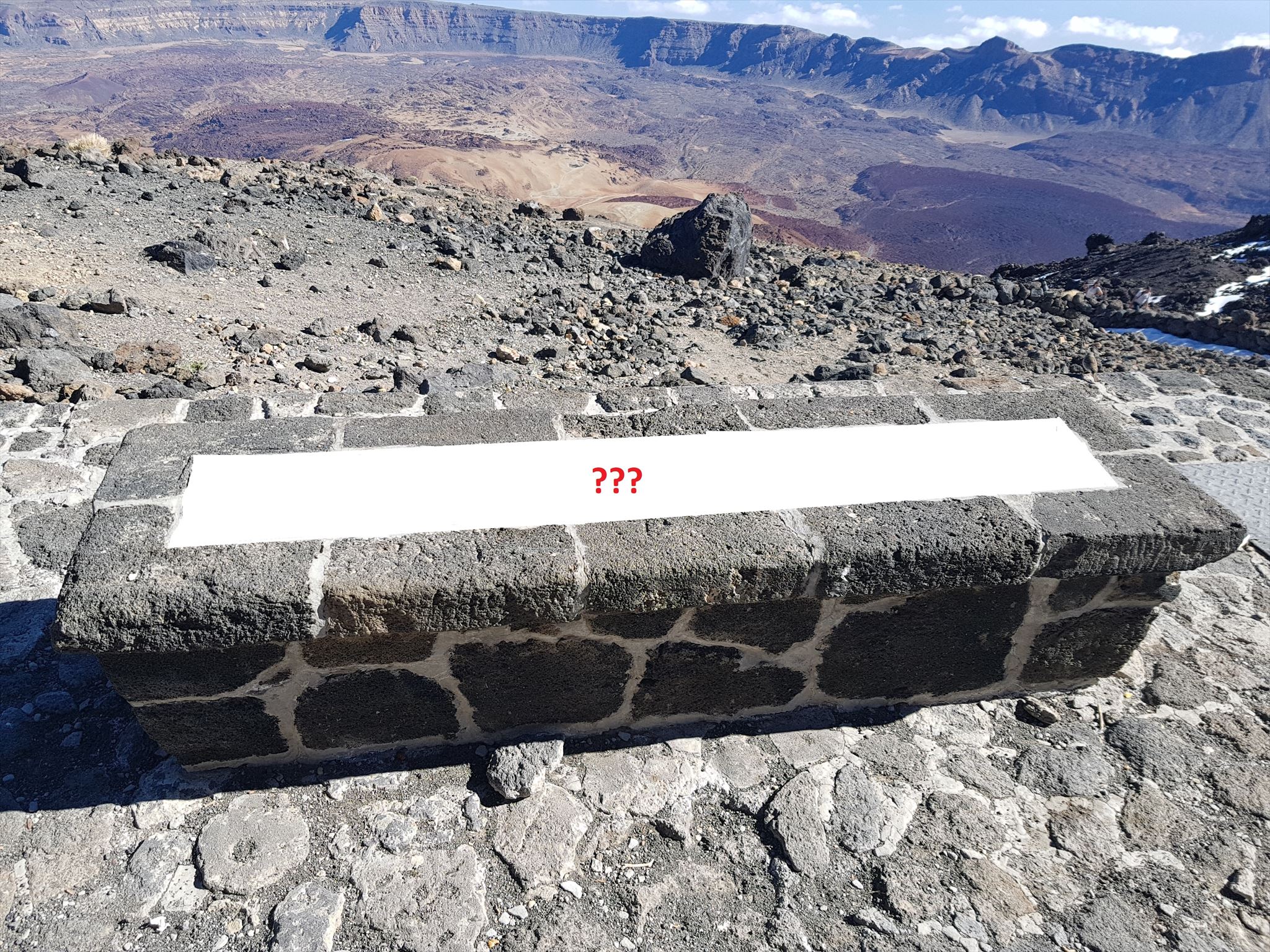
Stage 2: Refugio de Altavista (N 28° 16.443 W 16° 37.760)
In front of the Refugio, you can find a stone bench. There are E stones in the centre of the bench. Compare with the picture.
Vor dem Refugio könnt ihr auf einer Steinbank ausruhen. Es befinden sich E Steine in der Fläche, die ich im Bild geweißt habe.
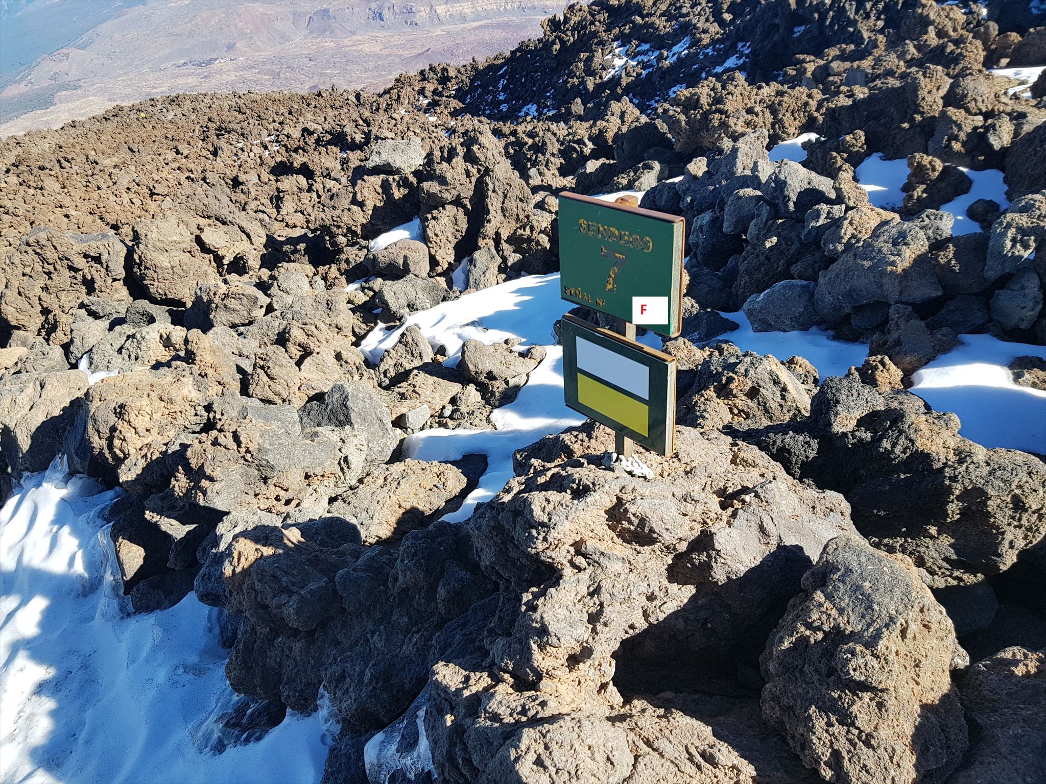
Stage 3: Sendero 7 (N 28° 16.432 W 16° 38.191)
F is the number of the sign of the Sendero 7 at the stage.
Die Nummer der Wandermarkierung des Sendero 7 an dieser Stelle ist F.
F es el número de la señal del Sendero 7 aqui.
Stage 4: Mirador El Fortaleza (N 28° 16.450 W 16° 38.350)
"During the eruption, the vulcano emitted black lava rich in obsidian. As a result, the vulcano gained about G metres in height forming the terminal cone."
Während der Eruption stieß der Vulkan schwarze Lava aus, die reich an Obsidian war. Als Ergebnis gewann der Vulkan G Meter an Höhe und formte so den endgültigen Kegel. Vergleicht mit der englischen/spanischen Inschrift auf der Tafel!
"Durante la erupción fueron emitidas lavas negras muy ricas en obsidiana. El volcán amuentó su altura en unos G metros, y se construyó el cono terminal."
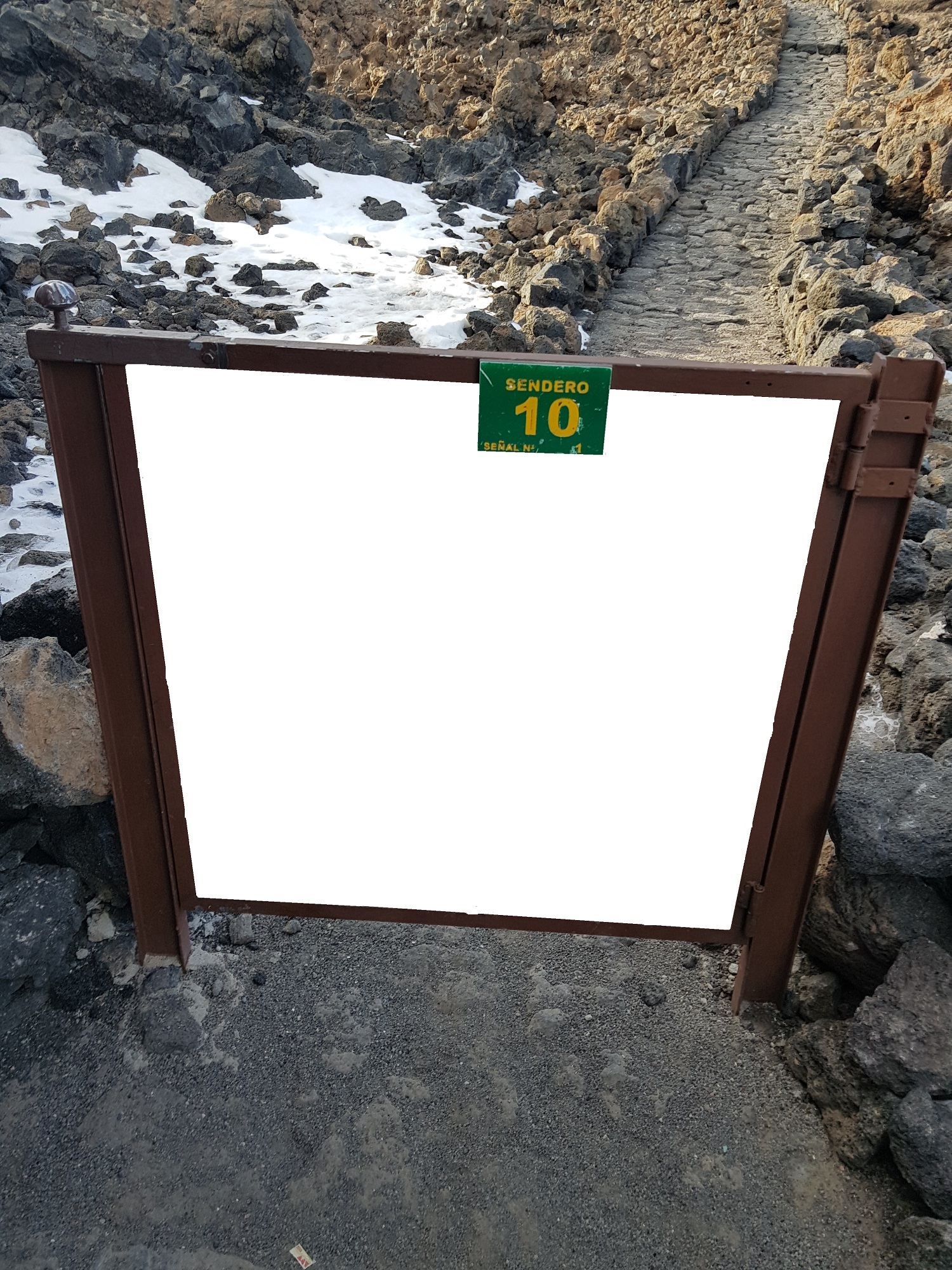
Stage 5: La Rambleta (N 28° 16.223 W 16° 38.323)
To be allowed to climb the summit of El Teide, you have to show your permit here. Make sure that you make a reservation beforehand as indicated at the top of the listing. There is a small gate with a sign of Sendero No. 10. How many vertical beams does it have inside the frame? = H
Hier müsst ihr eure Erlaubnis für die Gipfelbesteigung vorzeigen. Die Reservierung kostet nichts und muss im Vorfeld gebucht werden. (siehe zu Beginn des Listings) Am Durchlass befindet sich ein kleines Tor mit einem Schild des Sendero No. 10. Wieviele senkrechte Streben hat es innerhalb des Rahmens? = H
Aquí tienes que mostrar tu permiso para subir a la cumbre. La reserva no cuesta nada y debe reservarse con anticipación. En la alcantarilla hay una pequeña puerta con un letrero de Sendero No. 10. ¿Cuántos puntales verticales tiene? = H
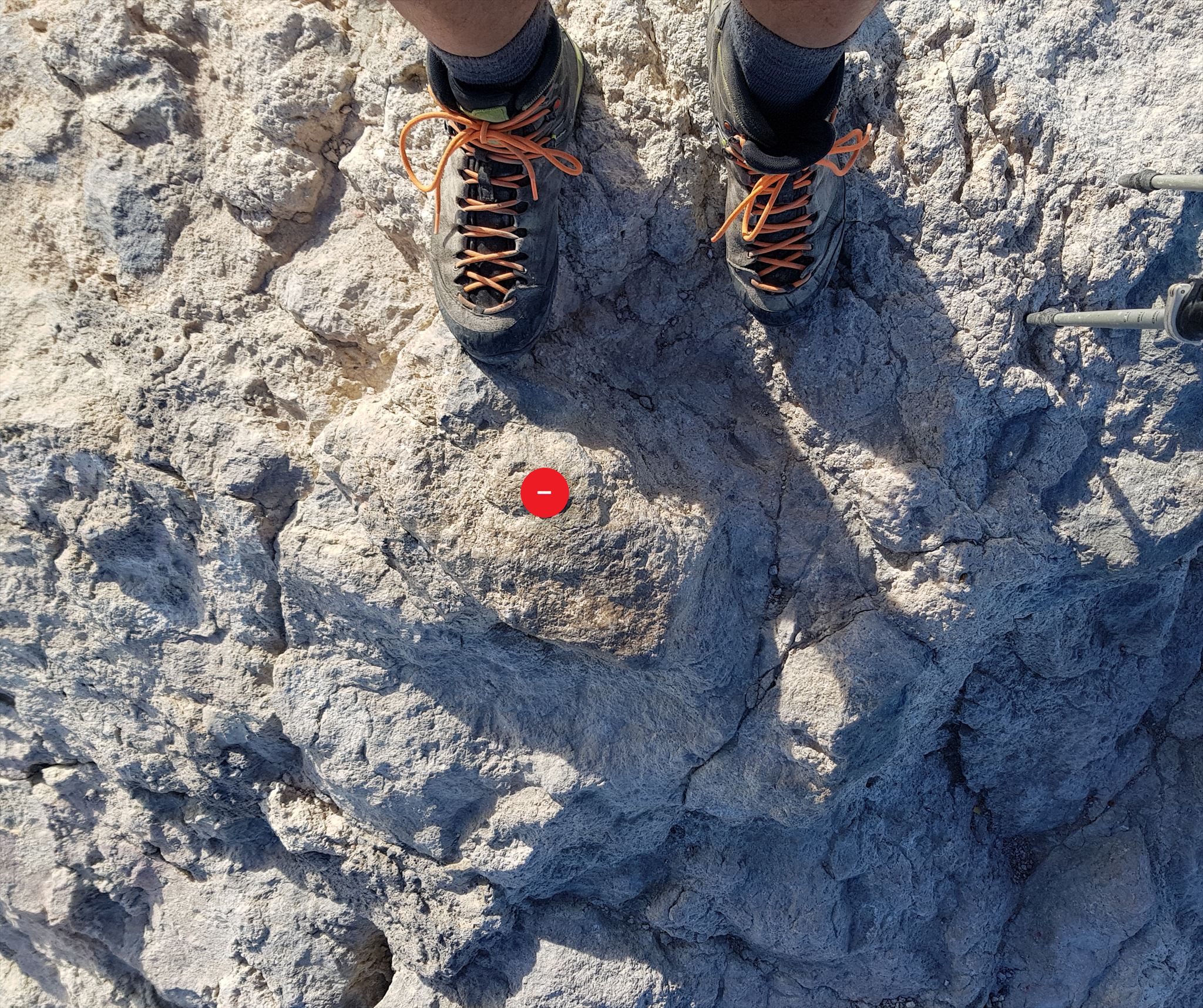
Stage 6: El Pico del Teide (N 28° 16.363 W 16° 38.539)
You have made it. You reached the highest point in Spain at 3718m. Climb on top of the rock that seems to be the highest point and look down to your feet. There is a triangulation point with three letters on it. Sum up their positions in the alphabet to get I.
Ihr habt es geschafft. Ihr habt auf 3718m über dem Meer den höchsten Punkt Spaniens erreicht. Klettert auf den Felsen, auf dem ihr auf subjektiv an der höchsten Stelle seid und schaut hinunter zu euren Füßen. Ihr findet einen Triangulationspunkt mit 3 Buchstaben darauf. Bildet die Summe der Buchstabenwerte für I.
Lo has logrado. Llegaste al punto más alto de España a 3718m. Sube a la cima de la roca que parece ser el punto más alto y mira hacia tus pies. Hay un punto de triangulación con tres letras. Resume sus posiciones en el alfabeto para obtener I.
Final
N 28° (D + E + F).(B - A + G - 2xI - D - H)
W 16° (I + E + F).(G + 3xC - H - F)
