Beavers Bend F🌎lds EarthCache

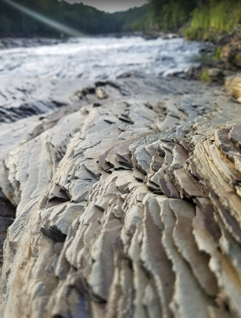
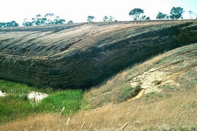
Beavers Bend State Park was named after John T. Beavers, a local Choctaw citizen, and was built on the site of an old Choctaw settlement. The "bend" in the park's name refers to an area of the park where a portion of Mountain Fork River meanders sharply, making an almost 180-degree turn. This EarthCache is located just northeast of this bend and will give you the opportunity to see some neat rock formations first hand!
To get credit for this EarthCache, be sure to complete the logging tasks at the bottom of this page.
Before We Begin:
- This is near the entrance of the Friends Trail, the newest trail in Beavers Bend State Park in 15 years! This trail is a 1.5 mile loop that is rated as intermediate with some rugged terrain and steep inclines but has some of the most beautiful views in the park and is family and pet friendly.
- Oklahoma State Parks have began charging a nominal fee to park within park grounds. See local signs near the parking area for more information.
- BEWARE: If you hear horns sounding, they are releasing water from the spillway upstream. This could cause the water to rapidly rise so be safe!
- There are two other EarthCaches nearby. Check them out: Beavers Bend N🌎vaculite and Beavers Bend 🌎verlook
As this is an EarthCache, there is no container to find. Instead you will have an opportunity to learn about the following:
- How did the Ouachita Mountains form?
- What are geological folds?
- What are the different types of geological folds?
Let's get started!
How did the Ouachita Mountains form?
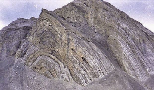
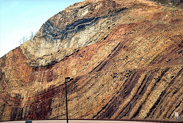
The Ouachita Mountains are what geologists call fold-and-thrust belts. Fold-and-thrust belts are mountain ranges that form as a result of compression. In terms of plate tectonics, they form when two of the earth's plates collide. When this occurs, horizontal rock layers are folded into anticlines (upfolds) and synclines (downfolds). In addition, one mass of rocks can be shoved or faulted over another, forming a thrust fault.
The Ouachita Mountains in Oklahoma are divided into three belts: frontal, central, and Broken Bow uplift. The Broken Bow uplift consists of these tightly folded rocks. The rocks in this uplift (Collier Shale to Arkansas Novaculite) are much older than those in the frontal belt and central belt. In fact, these rocks are among the oldest in the entire Ouachita Mountains and range in age from 350 million to 500 million years old (early Paleozoic). Considering the dinosaurs first roamed the earth about 240 million years ago, these are some seriously old rocks!
What are geological folds?
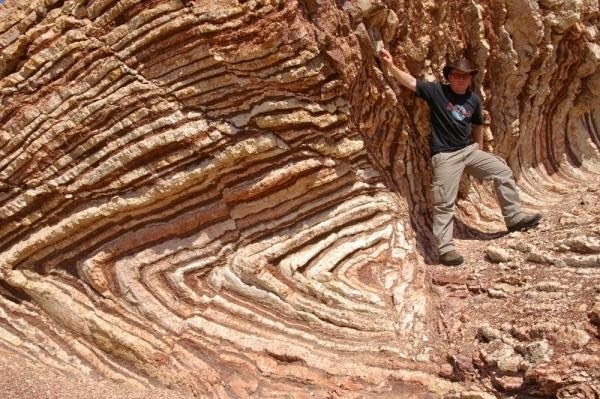
Rock often deforms in such a way that it bends instead of breaking. This is called a fold. The term fold is used in geology when one or a stack of originally flat, level surfaces, such as sedimentary strata, are bent or curved as a result of pressure and high temperature. The basic cause is thought to be the result of plate tectonics.
When two forces act towards each other from opposite sides, rock layers are bent into folds. The process by which folds are formed due to compression is known as folding. Folding is one of the endogenic processes (it takes place within the Earth's crust).
Folds in rocks vary in size from microscopic crinkles to mountain-sized folds. They occur singly as isolated folds and in extensive fold trains of different sizes, on a variety of scales. A set of folds distributed on a regional scale constitutes a fold belt, such as these in the Ouachita Mountains.
What are the different types of geological folds?
•Anticline: linear, strata normally dip away from axial center, oldest strata in center irrespective of orientation.
Anticline
•Syncline: linear, strata normally dip toward axial center, youngest strata in center irrespective of orientation.
Syncline
•Antiform: linear, strata dip away from axial center, age unknown, or inverted.
•Synform: linear, strata dip toward axial center, age unknown, or inverted.
•Dome: nonlinear, strata dip away from center in all directions, oldest strata in center.
Dome
•Basin: nonlinear, strata dip toward center in all directions, youngest strata in center.
•Monocline: linear, strata dip in one direction between horizontal layers on each side.
Monocline
•Homocline: a homocline involves strata dipping in the same direction, though not necessarily any folding.

Homocline
•Chevron: angular fold with straight limbs and small hinges.

Chevron
•Recumbent: linear, fold axial plane oriented at low angle resulting in overturned strata in one limb of the fold.
Recumbent
•Slump: typically monoclinal, result of differential compaction or dissolution during sedimentation and lithification.
•Ptygmatic: Folds are chaotic, random and disconnected. Typical of sedimentary slump folding, migmatites and decollement detachment zones.
Ptygmatic
•Parasitic: short wavelength folds formed within a larger wavelength fold structure - normally associated with differences in bed thickness.
•Disharmonic: Folds in adjacent layers with different wavelengths and shapes.
To Get Credit For This EarthCache
Copy the questions below and send your answers via geocaching messages.
- DO NOT post the answers in your log.
- Group answers are fine, just let me know who all was there.
- Note: The photo task is a requirement for each account claiming a find. See acceptable EarthCache logging tasks effective June 10th, 2019. If you don't want to post the photo with your log, you may send it to me with your answers instead.
- Please send the answers in a timely manner or it may result in the deletion of your log (no offense intended).
Logging Tasks
1| The name of this EarthCache: Beavers Bend F🌎lds
2| In your own words, what are geological folds and how do they occur?
3| Looking at the rock layers in front of you and using the information above, what kind of geologic fold do you think this is?
4| In your log, please provide a photo of yourself with the rock layers.
- If you prefer, the photo can be of a personal item here instead. Just make the photo unique to you and your visit. Feel free to have fun with this!
Optional: I'd love to see other photos you took from your visit here!
*IF YOU ENJOYED THIS EARTHCACHE,
CONSIDER GIVING A FAVORITE POINT!*
Sources:
Permission for this EarthCache placement was granted by Beavers Bend State Park.