
This is one of 12 caches placed for CAM 2020. You are required to find the nine physical caches and have your choice for number 10. It will be between 2 virtuals and a wherigo.
If you find all twelve, you will receive a special icon to download and put on your geocaching profile. Each location was picked specifically to give cachers a taste of the state and show you its beauty. By combining all of the caches, you'll be able to see why Maryland is truly "America in Miniature". We hope you enjoy them!
CAM 2020 - Oakley Cabin African American Museum and Park
Oakley Cabin was originally part of the Oakley Farm, which occupied a portion of Colonel Richard Brooke’s large land tract known as “Addition to Brooke Grove.” Brooke was a Revolutionary War hero known as “the Fighting Quaker.” He built the “big house” called Oakley in 1764, which was destroyed in the 1970s.
Brooke died in 1788 and willed all of his property to his only child, Ann, who later married William Hammond Dorsey. They had five children. Like her father, Ann and William never lived on the Oakley Farm. Instead, William built their home, Dumbarton Oaks, in Georgetown. When Ann died in 1802, William sold all of his Georgetown property and moved to Oakley, where he died in 1818. The Dorseys’ son, Richard B. Dorsey, transformed Oakley into a farm, on which his 23 slaves worked.
Dr. William Bowie Margruder bought Oakley farm in 1836. A local doctor to both white and black families, Margruder owned 19 slaves to help farm the land. Prior to 1879, two more cabins were built on the property, though neither remain. After Dr. Margruder died in 1873, Josiah J. Hutton purchased the farm.
According to census records from 1880 to 1920, between 22 and 37 people lived in the three cabins. The residents were both black and white, and worked as farm laborers, carpenters, blacksmiths, and laundresses. They likely shared household tasks and sold produce and hand-made articles to travelers on the Brookeville Road. The cross-section of cultures found here is representative of the unique African-American folk experience.
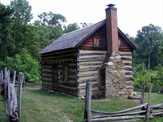
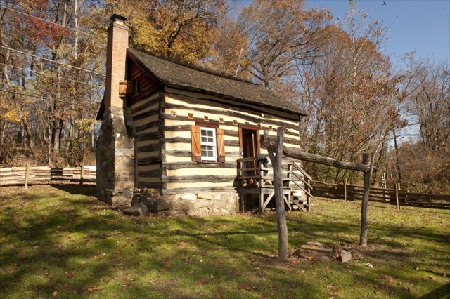
Step inside Oakley Cabin and immerse yourself in the history of those who have lived there. The main room on the ground floor wraps around an open hearth, and in a small adjoining room, 19th-century tools and artifacts are displayed. These items were excavated during archaeological digs around the park’s grounds. The two rooms are divided by a bead board partition wall, and a boxed staircase leads to the upper loft. Archaeologists are currently piecing together evidence in an attempt to date the construction of the cabin.
The 1½-story oak and chestnut log cabin is a reflection of vernacular architecture. The logs are joined with dovetail joints and chinked with stones, now largely covered with cement. The dove-tailed notching and artful pegging represent superb craftsmanship. The rafters on the roof are “bird-mouthed” over the top log that serves as a plate. The floor of the first level sits on a double sill with a notch in the foundation to allow room for two supporting logs – one for the floor and one for the wall.
The cabin sits on a 2-acre tract running along Reddy Branch. The mill pond for Newlin’s Mill was located in the low area behind the building. A trail, partially laid inside the old millrace, leads from the cabin to the site of the mill at the intersection of Brookeville Road and Georgia Avenue. You’ll see numerous wild plants here, many of which are edible or medicinal and were used by local people. Hawks, foxes, deer, raccoons, and other wildlife can often be seen from the cabin or trail, which also passes stone quarries used to dig local stone.
The coordinates of the cache are N 39 AB.CDE W077 VW.XYZ.
On the sign titled: Freedmen during Reconstruction in Montgomery County.
ABCD = Year of the Hopkins map of Oakley Cabin minus 802
E = Number of public schools for African-American children in Montgomery County prior to 1872
Green Sign with the Maryland National Capital Park and Planning Commission Logo at the top. Do NOT count this logo as one of the lines of the sign!
V = number of times Oakley is found minus number of times Reddy is found.
W = number of times Cabin is found plus number of times Brookeville is found minus number of times Montgomery is found
X = number of words on the first line of the sign
Y = number of letters in the first word of the middle line of the sign
Z = number of letters in the last word on the sign
The cache is in the vee of a downed tree, covered with natural cover. You may only search for this cache from dawn til dusk.

This Cache was placed by a Maryland Geocacher