English? - Scroll down please!
Deutsch? - Bitte nach unten rollen!
από www.cretanbeaches.com :
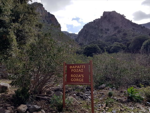
«Το φαράγγι της Ρόζας αποτελεί παρακλάδι του φαραγγιού της Αμπέλου. Ξεκινά από την περιοχή της Άνω Κεράς και κατηφορίζει ως το σημείο που συναντάει τον αγροτικό δρόμο που διασχίζει το φαράγγι της Αμπέλου. Καθώς η πεζοπορία μέσα στην κοίτη του φαραγγιού είναι αδύνατη λόγω απόκρημνων καταβάσεων, έχει διαμορφωθεί μονοπάτι στα πλάγια. Επίσης εντυπωσιακά υψώνονται τα πρανή του, με εμφανείς τους γεωλογικούς σχηματισμούς, που προσελκύουν το βλέμμα του επισκέπτη με την ιδιαίτερη ομορφιά που παρουσιάζουν. Το φαράγγι τούτο έχει επιφανειακό νερό, γεγονός που φαίνεται από τις πικροδάφνες που φύονται στην κοίτη του. Το όνομα φαίνεται να προέρχεται από τα ροζ τοιχώματα του φαραγγιού.»
-----
Στο Φαράγγι της Ρόζας βρίσκονται έξι μικρά Multi-Caches, το καθένα με ένα Στάδιο και το Φινάλε. Οι κρύπτες A, B και C οδηγούν από κάτω προς τα πάνω μέσα στο φαράγγι και τα Χ, Υ και το Ζ από πάνω προς τα κάτω. Έτσι όποιος ανεβαίνει ή κατέρχεται μέσω του φαραγγιού και επιστρέφει με τον ίδιο τρόπο θα βρει και στο δρόμο πίσω τρεις κρύπτες.
Το μονοπάτι έχει μήκος περίπου 1,5 χλμ. σε μια κατεύθυνση και έχει αρκετά απόκρημνα σημεία. Ακόμη και αν το μονοπάτι είναι ασφαλισμένα στα κρίσιμα σημεία με κιγκλιδώματα, θα πρέπει να φέρετε σίγουρη πόδι και να μην φοβηθείτε τα ύψη.
Σας συνιστώ να πάρετε πρώτα την ανάβαση και να ξεκινήσετε με την κρύπτη Α. Φυσικά, μπορείτε να έρχεστε από πάνω και ξεκινάτε με το Χ.
Για να μην μπερδεύετε, αναζητήστε ΑΝΕΒΑΙΝΟΝΤΑΣ ΜΟΝΟ A, B και C και ΚΑΤΕΒΑΙΝΟΝΤΑΣ ΜΟΝΟ X, Y και Z!
Στο φαράγγι, τα δέντρα συχνά σημειώνονται με ένα πράσινο σήμα στρογγυλού με λευκό αριθμό. Αυτοί οι αριθμοί χρησιμοποιούνται στα πρώτα Στάδια για τον υπολογισμό των συντεταγμένων των φινάλε.
Το σήμα GPS δεν είναι πολύ καθαρό μέσα στο φαράγγι! Λοιπόν, μην ξεκινήσετε χωρίς όλες τις φωτογραφίες βοήθειας «spoiler»! Χωρίς τις φωτογραφίες μπορεί να είναι πάρα πολύ δύσκολο να βρείτε όλα τα Στάδια και τα Φινάλε!
-----
Στο Στάδιο Α θα βρείτε ένα δέντρο που δείχνει τον αριθμό Α σε πράσινο σήμα.
Από αυτό το δέντρο θα ανεβείτε μέχρι θα βρείτε το φινάλε σε αυτές τις συντεταγμένες:
N 35° 13.(A+49) E 025° 26.(18xA+36)
Φέρτε το δικό σας στυλό!
********** English: **********
from www.cretanbeaches.com :
“The Gorge of Roza is an offshoot of the Gorge of Ambelos. It starts from a point near the rural road that crosses the gorge of Ambelos and has east-southeast direction, leading to Kera. The slope of the gorge is very high, but there is a path on the sides ideal for hiking. Moreover, the sides are impressive, with visible geological formations that attract the eyes of the visitors, with their special beauty special. The gorge has surface water, which seems from the oleanders growing in the riverbed. The name Roza is taken after the pinkish (roz/ροζ means pink) colors of the walls.”
-----
You will find in the Roza Gorge six short Multi-Caches, each with one station and the final. The geocaches A, B and C lead from the bottom up through the gorge and X, Y and Z from top down to the bottom. So whoever ascends or descends through the ravine and goes back the same way will find on his way back again three caches.
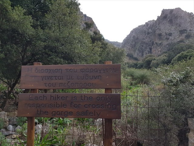
The trail is about 1.5 km long in one direction and has some quite steep spots. Even if the way is secured at the crucial places with railings, you should bring sure-footedness and no fear of heights.
I recommend to take the ascent first and start with can A. It goes of course, if you come from above and starts with X.
So that you don't get confused, search only for the geocaches A, B, and C ON YOUR WAS UP and only for X, Y and Z ON YOUR WAY DOWN!
In the gorge, trees are often marked with a green round badge with a white number. These numbers are used at the first stages to calculate the final coordinates.
Starting for the hike you should be sure to have downloaded all the spoiler-pictures, because the GPS-signal might be very poor in the gorge! Without the pictures it can be very difficult or impossible to find all the stages and finals!
-----
At Stage A you will find a tree bearing the number A on a green sticker.
From this tree you have to walk upwards until you will find the final at these coordinates:
N 35° 13.(A+49) E 025° 26.(18xA+36)
Βring your own pen!
********** Deutsch: **********
nach www.cretanbeaches.com :
“Die Schlucht von Roza ist ein Ableger der Schlucht von Ambelos. Sie beginnt an einem Punkt in der Nähe der Landstraße, die die Schlucht von Ambelos kreuzt und in Ost-Südost-Richtung verläuft, die zu Kera führt. Die Steigung ist sehr hoch, aber über die Seiten führt ein Weg, der ideal zum Wandern ist. Darüber hinaus sind die Hänge beeindruckend, mit geologischen Formationen, die auf die Besucher mit ihrer außerordentlichen Schönheit besonders beeindruckend sind. Die Schlucht hat Oberflächenwasser, welches den Oleander in ihrem Flussbett wachsen lässst. Der Name Roza beschreibt die Farbe der Felswände (roz/ροζ bedeutet rosa).”
-----
In der Roza-Schlucht liegen sechs Kurzmultis, jeweils mit einer Station und dem Finale. Die Geocaches A, B und C führen von unten nach oben durch die Schlucht und X, Y und Z von oben nach unten. Wer also durch die Schlucht auf- oder absteigt und auf demselben Weg zurück geht, findet auch auf dem Rückweg wieder drei Dosen.
Der Wanderweg ist in einer Richtung etwa 1,5 km lang und weist einige recht steile Stellen auf. Auch wenn der Weg an den entscheidenden Stellen mit Geländern gesichert ist, solltet Ihr Trittsicherheit und keine Höhenangst mitbringen.
Ich empfehle, zuerst den Anstieg zu nehmen und mit der Dose A zu beginnen. Es geht natürlich auch, wenn man von oben kommt und mit X beginnt.
Damit Ihr nicht durcheinander kommt, beachtet auf dem WEG NACH OBEN NUR A, B und C und auf dem WEG NACH UNTEN NUR X, Y und Z!
In der Schlucht sind Bäume häufig mit einer grünen runden Plakette mit einer weißen Nummer gekennzeichnet. Diese Nummern werden jeweils an den Vorstationen zur Berechnung der Finalkoordinaten genutzt.
Das GPS-Signal kann in der Schlucht recht ungenau sein. Deshalb achtet darauf, dass Ihr alle Spoiler-Bilder heruntergeladen habt, bevor Ihr startet. Ohne die Bilder kann es wegen des instabilen GPS-Signals sehr schwer bis unmöglich werden, alle Stages und Finals zu finden!
-----
An Stage A findet Ihr einen Baum, der auf einer grünen Plakette die Zahl A trägt.
Das Finale findet Ihr, wenn Ihr die Schlucht hinauf steigt, an diesen Koordinaten:
N 35° 13.(A+49) E 025° 26.(18xA+36)
Eigenen Stift mitbringen!