METROTRANVÍA
El caché no está en las coordenadas indicadas.
The cache is not at the posted coordinates.
Keš není na uvedených souřadnicích.
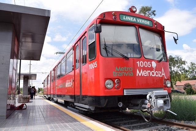

Un sistema de transporte público de tren ligero de superficie para la ciudad de Mendoza, prestado por trenes ligeros importados de San Diego, California. El sistema ha estado funcionando desde 2012 y al momento de colocar este geocaché tiene un recorrido de 17 kilómetros con 24 paradas. Hay planes en marcha para extender la línea hasta el aeropuerto de la ciudad. El Metrotranvía sirve al área metropolitana de Mendoza, que incluye los departamentos de Las Heras, Distrito Central, Godoy Cruz y Maipú. Más en el sitio web oficial y en Wikipedia.
CÓMO / DÓNDE
En el centro de la ciudad, corre a lo largo de la calle Belgrano y pasa justo por Arístide, calle famosa por sus bares y restaurantes. Dar un paseo también es una excelente manera de llegar a Maipú, donde se puede recorer la ruta del vino, y ver los suburbios de Mendoza desde un tren con aire acondicionado.
El servicio opera de 5:00 a 23:00 y la tarifa es de 18 pesos (febrero de 2020) 850 pesos (diciembre 2024). Para viajar, necesitarás la tarjeta SUBE de transporte público a nivel nacional. Si no tienes una, simplemente puedes pedirle a alguien a bordo que pague tu viaje a cambio del monto en efectivo. Es una práctica común en Argentina.
LA DIFUNTA RED DE TREN DE ARGENTINA
El Metrotranvía funciona en parte del antiguo Ferrocarril General San Martín, una línea que solía conectar la ciudad de Buenos Aires con los Andes y era parte de la antigua red ferroviaria argentina, que consistía en 47.000 km de ferrocarriles al final de la Segunda Guerra Mundial y fue, en su momento, uno de los más extensos y prósperos del mundo. Sin embargo, con el aumento en la construcción de carreteras y mala administración del estado, se produjo un fuerte descenso en la rentabilidad de los ferrocarriles, lo que llevó al cierre en 1993 de Ferrocarriles Argentinos (FFAA), la corporación ferroviaria estatal. Durante el período posterior a la privatización, se crearon compańías ferroviarias privadas y provinciales que resucitaron algunos de los principales ramales de pasajeros que FFAA alguna vez operaba. Se han realizado enormes inversiones en los últimos años para resucitar más líneas y crear ferrocarriles de alta velocidad. Lamentablemente, estos proyectos parecen estar muertos.
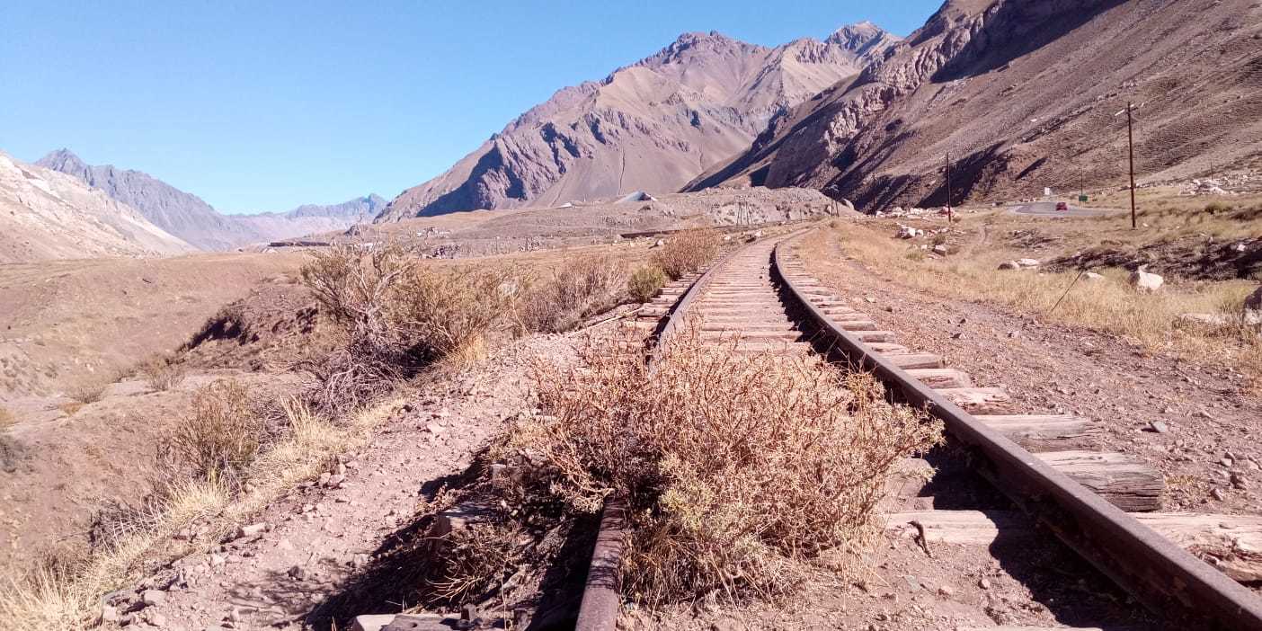
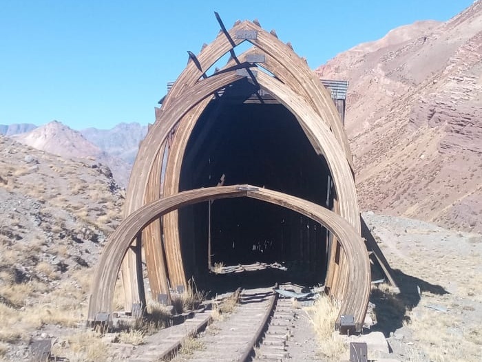
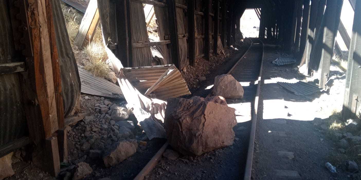
Sin embargo, la mayoría de la red que una vez fue grande ahora está clausurada y sus restos en descomposición se pueden ver en todo el país. Por ejemplo, la hermosa y abandonada estación de tren de Córdoba, o el icónico Ferrocarril Transandino de Mendoza a Los Andes de Chile, que pasaba a través del impresionante valle de Uspallata y justo al lado de la montaña Aconcagua, cruzando la frontera nacional a través de un túnel a 3200 metros sobre el nivel del mar. El último tren pasó por aquí en 1984 y la línea ha estado decayendo desde entonces. En el camino a Chile se pueden ver puentes caídos, túneles colapsados y secciones de rieles cubiertos de rocas caídas. Parte del material rodante argentino en descomposición se puede ver en las coordenadas iniciales, en la renovada estación de trenes de Mendoza, donde los restos de varios motores se están oxidando lentamente. Si te interesa obtener más información sobre el antiguo sistema de transporte de este país, hay diversos enlaces a páginas relevantes de Wikipedia.
COMO SOLUCIONAR EL GEOCACHE
Las etapas 1 y 2 se pueden hacer investigando en línea y leyendo este listado. Una vez que confirmes las coordenadas con el checker, diríjete a las coordenadas inciales para la etapa 3.
ETAPA 1)
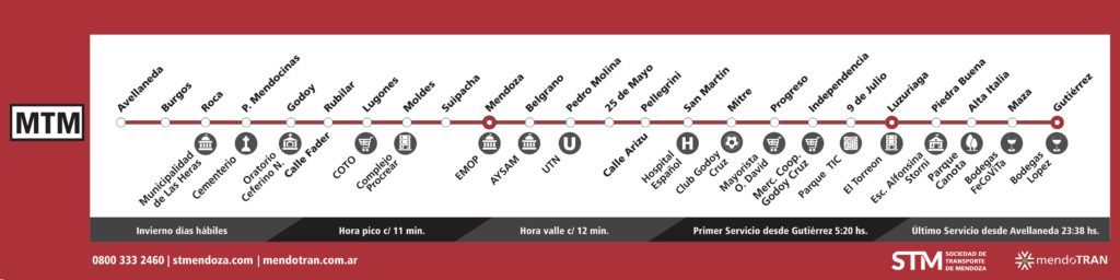
Conecta cada una de las 15 preguntas con el nombre de la estación de Metrotranvía correspondiente y suma el número de letras en cada respuesta (los números y los espacios no cuentan).
AVELLANEDA
BURGOS
ROCA
PATRICIAS MENDOCINAS
GODOY
RUBILAR
LUGONES
MOLDES
SUIPACHA
MENDOZA
BELGRANO
PEDRO MOLINA
25 DE MAYO
PELLEGRINI
SAN MARTIN
MITRE
PROGRESO
INDEPENDENCIA
9 DE JULIO
LUZURIAGA
PIEDRA BUENA
ALTA ITALIA
MAZA
GUTIÉRREZ
A) Estás aquí
B) Pueblo en la provincia de Salta que lleva el nombre de un líder militar local
C) Con la independencia viene...
D) No hay progreso sin...
E) Cruzó los Andes con su ejército en 1817
F) El creador de la bandera argentina
G) ¿Dónde buscarías el paso de montaña Brennero?
H) Séptimo gobernador de Buenos Aires y presidente de dos pesos
I) Ciudad en la provincia de Buenos Aires que lleva el nombre de un presidente desde 1904
J) ¡Argentina está libre!
K) Presidente de Argentina y agua mineral italiana
L) Pueblo de la provincia de Santa Cruz
M) Autor de La Guerra Gaucha
N) Batalla de... (en Bolivia en 1810)
O) ¡La revolución comienza ahora!
(A+B+C...+O) = XXX
ETAPA 2)
Responde las siguientes preguntas:
P) Año de inauguración del Metrotranvía de Mendoza.
Q) Año en que se disolvió la empresa ferroviaria nacional argentina.
R) Altitud (en metros) del cruce fronterizo nacional del ferrocarril Transandino.
S) Número de paradas de Metrotranvía al momento de colocar este caché.
(P + Q) - R - S - 46 = YYY
COORDENADAS PARA EL CHECKER (no es el final, no vayas allí):
S32 53.XXX W68 50.YYY
ETAPA 3)
Realiza un breve paseo por la estación para encontrar la información a continuación, calcúla las coordenadas y anda por el caché.
T) Número de pilares de acero que sostienen el techo sobre los andenes.
U) Número de semáforos (exclusivos para peatones) en los pasos a nivel a ambos lados de la estación.
V) Último dígito del gran número morado visible en la locomotora naranja detrás del muro.
W) Número de palabras pintadas en blanco en la puerta del Tren Cultural Museo.
X) Número de tornillos pintados en rojo en el frente de la locomotora del tren.
XXX - (T*W) +X-2 = final
YYY + (X*V) + T+U+V+W+X-15 = final


A public light rail overground transport system for the city of Mendoza, served by trains imported from San Diego, California. The system has been operating since 2012 and at the time of placing this geocache it runs for 17 kilometres with 24 stops. Plans are underway to extend the line until the city's airport. The Metrotranvía serves the metropolitan area of Mendoza, which includes the departments of Las Heras, Central district, Godoy Cruz and Maipú. More on the official website and on Wikipedia.
HOW TO / WHERE TO
In the city centre, it runs along Belgrano street and it passes right by the Arístide, the street famous for its bars and restaurants. Taking a ride is also an excellent way to reach Maipú, popular for wine tours, and to see Mendoza's shabby suburbs from an air-conditioned train.
Service operates from 5:00 to 23:00 and the fare is 18 pesos (February 2020) 850 pesos (December 2024). You will need the nation-wide public transportation card SUBE. If you don't have one, simply ask someone on board to pay for your ride and give them cache (but cash is better :). It is common practice in Argentina.
ARGENTINA'S DEFUNCT TRAIN NETWORK
The Metrotranvía runs on part of the former General San Martín Railway, a line that used to connect the city of Buenos Aires with the Andes and was part of the once-great Argentine railway network, which consisted of a 47,000 km (29,204 mi) of railways at the end of the Second World War and was, in its time, one of the most extensive and prosperous in the world. However, with the increase in highway construction and bad state administration, there followed a sharp decline in railway profitability, leading to the break-up in 1993 of Ferrocarriles Argentinos (FA), the state railroad corporation. During the period following privatisation, private and provincial railway companies were created and resurrected some of the major passenger routes that FA once operated. Huge investments have been made in recent years to resurrect more lines and create high-speed railways, but these projects now seem stalled.
The majority of the once-great network is now defunct and its decaying remnants can be seen all over the country. For example the beautiful and abandoned train station in Córdoba, or the iconic Transandine Railway from Mendoza to Los Andes in Chile, which passed through the stunning Uspallata valley and right by Mount Aconcagua, crossing the national border through a tunnel at 3200 metres above sea level. The last train passed through here in 1984 and the line has been decaying ever since. Fallen bridges, collapsed tunnels and sections of rails being reclaimed by falling rocks can be seen on the way to Chile. Some of the decaying Argentine rolling stock can be seen at GZ, at the refurbished Mendoza train station, where the remains of several engines are slowly rusting away. If you are interested in more history of this country's former transportation system, follow the various links to relevant Wikipedia pages.
HOW TO FIND THE CACHE
Stages 1 and 2 can be done remotely with a bit of googling and by reading this listing. Once you confirm the coordinates with the checker, head to GZ for stage 3.
STAGE 1)
Connect each of the 15 questions with the name of the corresponding Metrotranvía station and sum the number of letters in each name (numbers and spaces do not count).
AVELLANEDA
BURGOS
ROCA
PATRICIAS MENDOCINAS
GODOY
RUBILAR
LUGONES
MOLDES
SUIPACHA
MENDOZA
BELGRANO
PEDRO MOLINA
25 DE MAYO
PELLEGRINI
SAN MARTIN
MITRE
PROGRESO
INDEPENDENCIA
9 DE JULIO
LUZURIAGA
PIEDRA BUENA
ALTA ITALIA
MAZA
GUTIÉRREZ
A) You are here
B) Town in Salta province named after a local military leader
C) With independence comes...
D) There is no progress without...
E) He crossed the Andes with his army in 1817
F) The creator of the Argentine flag
G) Where would you be looking for the Brennero mountain pass?
H) 7th governor of Buenos Aires and the president of two pesos
I) City in Buenos Aires province named after a president in 1904
J) Argentina is free!
K) President of Argentina and Italian mineral water
L) Town in the province of Santa Cruz
M) Author of The Gaucho War (La Guerra Gaucha)
N) Battle of... (fought in Bolivia in 1810)
O) The revolution starts now!
(A+B+C...+O) = XXX
STAGE 2)
Answer the following questions:
P) Year the Mendoza Metrotranvía was inaugurated.
Q) Year the Argentine national railway company was disbanded.
R) Altitude (in metres) of the Transandine railway national border crossing.
S) Number of Metrotranvía stops at the time of placing this cache.
(P + Q) - R - S - 46 = YYY
CHECKER COORDS (not the final, don't go there):
S32 53.XXX W68 50.YYY
STAGE 3)
Take a short walk around GZ to find the information below, integrate it with the checker coordinates and go to the final.
T) Number of steel pillars supporting the roof over the platforms.
U) Number of (pedestrian-only) traffic lights at level crossings on both sides of the station.
V) Last digit of big purple number visible on the orange locomotive behind the wall.
W) Number of white-painted words on the Tren Cultural Museo's door.
X) Number of red-painted bolts on the train engine's front side.
XXX - (T*W) +X-2 = final
YYY + (X*V) + T+U+V+W+X-15 = final

Lehkou nadzemní dráhu města Mendoza brázdí tramvaje dovezené z kalifornského San Diega. Dráha funguje od roku 2012 a v době umístění této keše měla délku 17 km a 24 zastávek. Plánuje se protažení trasy až na místní letiště. Metrotranvía obsluhuje metropolitní oblast Mendozy a projíždí přes městské části Las Heras, Centrum, Godoy Cruz a Maipú. Více info na oficiálních stránkách, na Wikipedii a pro české kačery i v tomto skvělém článku od Československého dopraváka, popisujícím nejen putování tramvajových souprav z Kalifornie až do Mendozy, ale i detailnější pohled na níže popsanou historii argentinských železnic.
KUDY KAM
V centru je dráha vedena ulicí Belgrano a projíždí okolo ulice Arístide, vyhlášené pro své bary a restaurace. Nadzemka je skvělý způsob, jak se dostat do Maipú – populární destinace pro návštěvy místních vinařství – a jak z klimatizovaného vláčku zhlédnout ošuntělou periferii.
Služba je v provozu od 5:00 do 23:00 a za jednu jízdu zaplatíte 18 pesos (únor 2020) 850 pesos (prosinec 2024). Budete potřebovat buď celonárodní kartu SUBE pro veřejnou dopravu, nebo požádat někoho z cestujících, aby za vás zaplatil jízdné, a dát mu odpovídající částku jako cache (nebo radši cash :). V Argentině je to běžná praxe.
ZANIKLÁ ARGENTINSKÁ ŽELEZNICE
Metrotranvía využívá část bývalé Železnice generála San Martína, páteřní tratě spojující Buenos Aires s Andami. Ta kdysi tvořila část proslulé argentinské železniční sítě, jež na konci 2. světové války čítala 47 000 kilometrů kolejí a ve své době patřila k největším a nejvíc prosperujícím železničním sítím na světě. Silniční rozvoj a špatná státní správa bohužel vedly k postupnému úpadku a v roce 1993 byla národní drážní společnost Ferrocarriles Argentinos (FA) rozpuštěna. Soukromé a krajské společnosti při následné privatizaci oživily část hlavních tras pro přepravu cestujících. V posledních letech došlo k novým investicím a k pokusům vzkřísit další trasy a vybudovat vysokorychlostní tratě, tyto projekty se však v současnosti zdají být u ledu.
Většina kdysi slavné sítě je dnes v rozkladu a její chátrající pozůstatky jsou vidět po celé zemi. Například krásné, ale opuštěné nádraží v Cordobě, nebo ikonická Transandská železnice z Mendozy do Los Andes v Chile, která vedla přes impozantní Uspallatské údolí, kolem hory Aconcagua, a státní hranici překračovala tunelem v nadmořské výšce 3200 metrů. Poslední vlak tudy projel v roce 1984 a od té doby trasa chátrá. Cestou do Chile lze vidět spadlé mosty, zavalené tunely a úseky železnice pokryté kamením. Část argentinského vozového parku – několik starých lokomotiv – pomalu rezaví na výchozích souřadnicích před restaurovaným Mendozským nádražím. Pokud chcete vědět více o historii někdejšího přepravního systému této země, příslušné odkazy na Wikipedii a výše uvedený článek vás navedou.
JAK NA KEŠ
K 1. a 2. stage stačí pohledat na internetu a přečíst si listing. Jakmile vám checker potvrdí souřadnice, vydejte se na na GZ pro 3. stage.
STAGE 1)
Spojte všech 15 otázek s názvem příslušné zastávky a sečtěte počet písmen v každé odpovědi (číslice a mezery se nepočítají).
AVELLANEDA
BURGOS
ROCA
PATRICIAS MENDOCINAS
GODOY
RUBILAR
LUGONES
MOLDES
SUIPACHA
MENDOZA
BELGRANO
PEDRO MOLINA
25 DE MAYO
PELLEGRINI
SAN MARTIN
MITRE
PROGRESO
INDEPENDENCIA
9 DE JULIO
LUZURIAGA
PIEDRA BUENA
ALTA ITALIA
MAZA
GUTIÉRREZ
A) Jste tady
B) Město v provincii Salta pojmenované po místním vojevůdci
C) S nezávislostí (independencia) přichází...
D) Není pokroku (progreso) bez...
E) V roce 1817 překročil Andy se svou armádou
F) Tvůrce argentinské vlajky
G) Kde byste hledali horský průsmyk Brennero?
H) 7. guvernér Buenos Aires a prezident za dva pesos
I) Město v Buenos Aires, které roku 1904 pojmenovali po prezidentovi
J) Argentina je svobodná!
K) Argentinský prezident a italská minerálka
L) Městečko v provincii Santa Cruz
M) Napsal Válku gaučů (La Guerra Gaucha)
N) Bitva o... (vybojovaná v Bolívii v roce 1810)
O) Revoluce začíná!
(A+B+C...+O) = XXX
STAGE 2)
Odpovězte na následující otázky:
P) Rok inaugurace Mendoza Metrotramvía.
Q) Rok, kdy byly rozpuštěny argentinské národní železnice.
R) Nadmořská výška pohraničního tunelu Transandské železnice.
S) Počet zastávek Mendozské tramvaje v době umístění této keše.
(P + Q) - R - S - 46 = YYY
SOUŘADNICE DO CHECKERU (nejsou finální, nechoďte tam):
S32 53.XXX W68 50.YYY
STAGE 3)
Projděte se okolo úvodek, najděte níže uvedené informace, zapracujte do souřadnic z checkeru a vydejte se pro kešku.
T) Počet ocelových sloupů podpírajících střechu nástupiště.
U) Počet semaforů pro chodce u přechodů přes koleje na obou stranách nádraží.
V) Poslední číslice velkého fialového čísla na oranžové lokomotivě za zdí.
W) Počet slov napsaných bílou barvou na dveře vagónu Tren Cultural Museo.
X) Počet červeně natřených šroubů na přední straně lokomotivy.
XXX - (T*W) +X-2 = finálka
YYY + (X*V) + T+U+V+W+X-15 = finálka
Agradecimientos especiales / Special thanks / Zvláštní poděkování:
"The Sheriff" arieltuc por la version española