 This earthcache highlights the ongoing geological history of the Gouland Downs. Limestone landscapes undergo typical stages of geological succession depending on the intensity and duration of erosive forces. As you explore the Enchanted Forest, look at the caves and cliffs and decide what stage this limestone landscape has reached. What will it look like in the future?
WARNING: There are many sinkholes in the limestone, some hidden by bush.
Take care at all times and if you leave the established routes, stay on high ground.
The attached DoC sketch map, DoC information and waypoints will help you find the caves.
(1) Hut cave (this earthcache) (2) Under-the-track caves (3) Waterfall cave & GC50175
- DoC recommend that you leave your backpack either at Gouland Downs Hut or where you leave the track, to avoid accidentally damaging the cave formations.
- Bring a torch – to look at features inside the caves. You will also need a camera for the final logging task.
- Read through the cache description and logging tasks before you start the Heaphy, so you know how to get to GZ and what information you're looking for.
- Print out the cache description and pictures and take it with you. The cache description is long and difficult to read on a device.
- You will need to schedule enough time to explore the area properly - this is definitely a higher difficulty cache.
HOW TO GET TO GZ: HUT CAVE & "COLUMN CAVE"
How to get to Hut Cave:
Walk along the Heaphy Track from Gouland Downs Hut towards the forest, just past the bend halfway along the track. At the "Hut Cave track entry"
waypoint, on your right down the bank is a faint trail into the tussock. Look for signs of takehe grazing - can you see takahe scat?
Scramble down the bank and follow the trail, into the bush and through the trees to the Hut Cave overhang.

LOGGING TASKS
The information further down the page, about the area's geological history and the stages of erosion of a limestone landscape, will help you answer these questions.
1. Somewhere on the track between the Heaphy Track and Hut Cave, you crossed from sandstone to limestone. Where? Backtrack to this point, stop and take a waypoint.
1 a) Email the CO the coordinates of the limestone/sandstone boundary.
1 b) Explain why you identified this point as being the edge of the limestone outcrop.
As you stand outside Hut Cave, look at how much the caves are eroded and the height of the cliffs and think about what stage this limestone landscape has reached.
Now explore "Column Cave":
Facing the large Hut Cave, scramble up the bank to your right. Slightly above and to the right of Hut Cave, you will find the entrance of a smaller cave. Inside this "Column Cave" are some cave decorations - stalacites, and a single large column, formed where a stalactite and stalagmite have joined. TAKE GREAT CARE when you go to the end of this cave – there is a drop-off.
2 a) How far inside the cave is the column (i.e. right at the entrance, halfway back in the dark, or at the very end of the cave)?
2 b) What does this tell you about how far the limestone around the cave has already been eroded?
CAREFULLY, go to the end of "Column Cave", stop at the drop-off, and look down. You will see a connecting cave below. This is where the New Zealand Forest Service Meat Safe used to be (still is, but now covered by a roof collapse, it seems). What a cool place to cache your perishable food!
Now explore the main Hut Cave (you might see cave weta in the dark at the back, but you don't need to go that far if you don't want to).
3) Do you see any evidence of the cave starting to collapse? If so, what do you see (e.g. are there any rockfalls, or holes in the ceiling)?
4) Take a photo of the of the entrance of the Hut Cave including you, your GPS, a trackable or other personal item. See the photo above, of Mr Daywalk looking out of the Hut Cave, as an example. Post this photo with your log.
5) Now you have explored this part of the Enchanted Forest, imagine what the area might look like in future. What do you think the landforms here might look like in 200,000 years, and why?
In your explanation discuss what erosion stage the Enchanted Forest limestone landscape is at now, the thickness of the limestone rock layer, and the ongoing geological processes affecting the landscape.
Please email or message us your answers to the earthcache questions and log your find at the same time. Only post the photo of the Hut Cave entrance with your log. If you cannot send the answers immediately then it would be better to log a note about your visit, and then change your note to a find log when you do send the answer email. Your log date will be the day you visited the caves. If your answers are incorrect or incomplete you will be asked to provide more details.
|
Aerial view of Gouland Downs showing the Enchanted Forest.
Why does an isolated patch of beech forest grow in the middle of this tussock plain?
Why are there limestone caves here in the middle of an area of sandstone and granite rock?
|
 |
GOULAND DOWNS GEOLOGICAL HISTORY
The plants show what type of rock lies beneath
The vegetation on the Gouland Downs shows the type of rock that lies underneath. The old sandstones of the Downs form shallow, acidic, infertile soils which are often waterlogged, covered in red tussock and other plants that can tolerate such condition. In contrast, the limestone outcrops support luxuriant beech forest. Some of the youngest limestone rock in New Zealand on top of some of the oldest sandstone... how did they end up here?
Old Rocks and uplift
The Gouland Downs rocks are some of the oldest in New Zealand, part of the Buller terrane. They are the Aorangi Mine Formation, quartz-rich sandstone and black mudstones, laid down 490 - 443 million years ago adjacent to Gondwana. Intrusions of magma 370 - 354 million years ago cooled to form nearby areas of Karamea Granite (which explains those huge granite boulders beside the track on Mackay Downs). The Tuhua mountain-building period (370 - 330 million years ago) uplifted these Western Province rocks.

More rocks and more uplift
Over hundreds of millions of years, other rocks formed and were amalgamated into the margins of Gondwana. The Rangitata mountain-building period (145 - 100 million years ago) uplifted the Eastern province, the rest of the future Zealandia.

Erosion
Then there was a long period with no tectonic activity. Through to about 70 million years ago, parts of the future South Island were worn down by slow weathering and erosion to a nearly flat, level plain, close to sea level – the Cretaceous peneplain (or perhaps the Waipounamu Erosion Surface). The Gouland Downs are a remnant of this erosion surface. The nearby Mackay Downs, Gunner Downs, Mount Arthur Tablelands and the Central Otago peneplain are part of this same ancient plain.
Separation of Zealandia
100 million years ago a rift developed beneath Gondwana. A huge chunk of land, two-thirds the size of Australia, was split off from the super-continent and pushed out into the Pacific.

Going Under
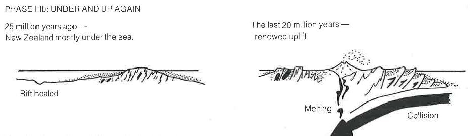
As it separated from Gondwana, Zealandia cooled and slowly sank, some 2-3 kilometres over the next 60 million years. It became almost completely covered by shallow seas. Here in North-west Nelson between 33.7 and 23.8 million years ago the Nile Group limestones were deposited on top of the eroded, ancient, Aorangi Mine Formation sandstones.
NZ emerges
About 23 million years ago, collision between the Pacific and Australian plates began the Kaikoura mountain-building period. Part of Zealandia was pushed up above the sea, forming the islands of New Zealand. The uplift accelerated in the last 5 million years.
 Weathering removes the overlying younger rocks
The Pacific and Australian plates collide along the Alpine Fault, and the present uplift rate of the Tasman region is 1 - 5 mm. That's perhaps 3 km in a million years, or 15 km in the past 5 million years!
But, incredibly, New Zealand is eroding away almost as quickly as the tectonic plate collision is pushing it up. Since the Tasman region re-emerged above sea level, the forces of erosion have gnawed away at the softer marine sediments that were overlying the basement rocks underneath.
Here at the Gouland Downs, almost all the soft Nile Group limestone has weathered away, leaving only a few scattered outcrops (like this Enchanted Forest) still remaining, on top of the harder Aorangi Mine Formation sandstone that is more resistant to erosion. We can see the location of the limetone outcrop because tussock is able to grow on the the infertile sandstone, while beech trees can only grow on the fertile limestone.
LIMESTONE LANDSCAPES
Weathering and erosion is particularly fast in limestone rock. For example, the erosion of limestone blocks in Roman-period walls has been measured at about 10 cm per thousand years. At this rate, twenty metres of limestone rock would erode away purely by chemical processes in about 200,000 years.
Limestone landscapes undergo typical stages of geological succession as they undergo weathering. As you explore the Enchanted Forest, look at how much the caves are eroded and the height of the cliffs and decide what stage this limestone landscape has reached.
1. Initiation stage, shortly after uplift from the sea, with cavities starting to form as the limestone begins to erode?
2. Youth stage, with caves formed? Cave decorations like stalactites and stalagmites will be growing deep inside these caves.
3. Mature stage, with a badly weathered landscape and a disturbed ground surface? As this stage progresses, caves will be weathered out to their depths, showing the old cave decorations inside. Eroded cave ceilings will collapse in, making sinkholes in the surface above.
4. Or old age stage, with the limestone almost completely eroded and only isolated pinnacles of limestone remaining?


Remember that geological processes are ongoing. The limestone outcrops on Gouland Downs are continuing to erode, day by day and century by century. What will the Gouland Downs look like as time goes on?

HUT CAVE HISTORY
The first people using the Heaphy Track route, gold prospectors and shepherds in the 1860s, slept in the Hut Cave.
Later a rough hut was built for stockmen taking stock over the track and, when the Downs was declared a Wildlife Sanctuary in 1915, a ranger’s hut.
The present Gouland Downs Hut was built by the Collingwood County Council in 1936, added to and renovated over the years.
Hut Cave was used by Forest Service rangers to store equipment when they were based here. Their big meat safe can still be seen perched on a ledge not far into the cave. That was already old in January 1972, when Mrs daywalk visited it with her parents, walking the Heaphy.


There were no dehydrated meals back in the 1940s and 50s - the rangers would carry in supplies and also shoot deer for meat. The meat safe, with wire mesh inserts, kept off blowflies and allowed air flow to keep the perishable food cool.
The NZFS guys chose a perfect site for their safe! Inside the cave it's dry, with a stable cool underground temperature. Evaporation from the small stream in the cave cools the air even more in summer. In particular, the interconnection of caves gives a constant airflow past the meat safe to keep the meat fresh as long as possible. What a cool place to cache your perishable food!
Information:
