
DESCRIPCIÓN GENERAL
Este geocache es parte de una pequeña serie dedicada a la excelente travesía, ideal para excursionistas experimentados que buscan un desafío tanto técnico como físico. Es accesible solo en verano, tiene 46 km de largo, conecta los cuatro refugios más emblemáticos del Parque Nacional Nahuel Huapi y generalmente demora de 3 a 4 días en completarse (cada refugio tiene su propia ruta de acceso desde la ciudad, por lo que el recorrido se puede dividir en etapas). Los pernoctes se realizan en los refugios con personal (se requiere reserva y pago) o en los campamentos adyacentes (gratis).
Para obtener información detallada sobre el sendero, los mapas y gps track, la reserva de refugios, los guías y el formulario de registro del parque nacional (obligatorio), visite Barilochetrekking.com. También se pueden contratar guías a través de las numerosas agencias de turismo de la ciudad. Los excursionistas experimentados no deberían tener problemas para abordar el sendero por su cuenta, pero algunas secciones no están tan bien marcadas y podrían ser difíciles con una mala visibilidad. Algunas secciones rocosas empinadas se vuelven resbaladizas y están prohibidas durante el clima lluvioso. También deben tener en cuenta que el recorrido solo es accesible durante el verano (de diciembre a abril).
DESCRIPCIÓN DEL CAMINO
Aunque la travesía se puede hacer en ambas direcciones, es muy recomendable y mucho más seguro, debido a las diferentes secciones empinadas en terreno suelto, comenzar en el centro de esquí Cerro Catedral (colectivo n. 55 desde Bariloche). Desde aquí, el sendero se dirige al refugio Emilio Frey (GC8MNKK) a lo largo de su ruta tradicional (a medio camino puedes descansar cerca del Refugio Petricek, administrado por el Club Andino Esloveno. Lamentablemente, este pequeño lugar ya no funciona). Luego continúa hacia la laguna Schmoll (GC8MNKB), cerca del filo de los Picos Catedral, desde donde desciende abruptamente hasta el valle del arroyo Rucaco. Después de un breve período dentro de un bosque tranquilo, sube al filo Brecha Negra y nuevamente desciende abruptamente hasta la laguna Jakob y el refugio San Martín (espacioso y moderno).
A partir de aquí, una subida ligeramente técnica (prohibida durante el clima húmedo) conduce al "Cordón de los inocentes". Luego a través de una brecha (GC8MNM0) con vistas a la laguna Navidad, alrededor del "Circo glaciario" y hasta el Cerro Navidad, 2093 m. Lo que sigue es un descenso aún más empinado hacia el valle, donde se une al sendero que viene de Colonia Suiza, y sube por las curvas (El Caracol, GC1PQ4C, no es mi caché) hasta el refugio rústico, románticamente iluminado por velas en las orillas de la Laguna Negra, con los mejores campings.
Desde aquí, otra subida hasta el Bailey Willis (1950 m), hasta la cuenca del arroyo Goye (donde las vacas contaminan la fuente de agua) y luego otra vez en un acantilado suelto y extremadamente empinado hasta el filo del López (cerca de Pico Turista, 2070 m, GC8MNKT) con espectaculares vistas de 360° del Cerro Tronador, el Lago Nahuel Huapi y varios picos de Chile, incluidos el Volcán Osorno y el Cerro Puntiagudo. Finalmente, el camino te castiga con una bajada agotadora sobre rocas alisadas por miles de pisadas hasta el último refugio, el López. Desde aqui, el camino se convierte en una pista 4x4 (con atajos polvorientos) que te escupe al Circuito Chico cerca del desvío de Colonia Suiza, donde hay estacionamiento y transporte público.
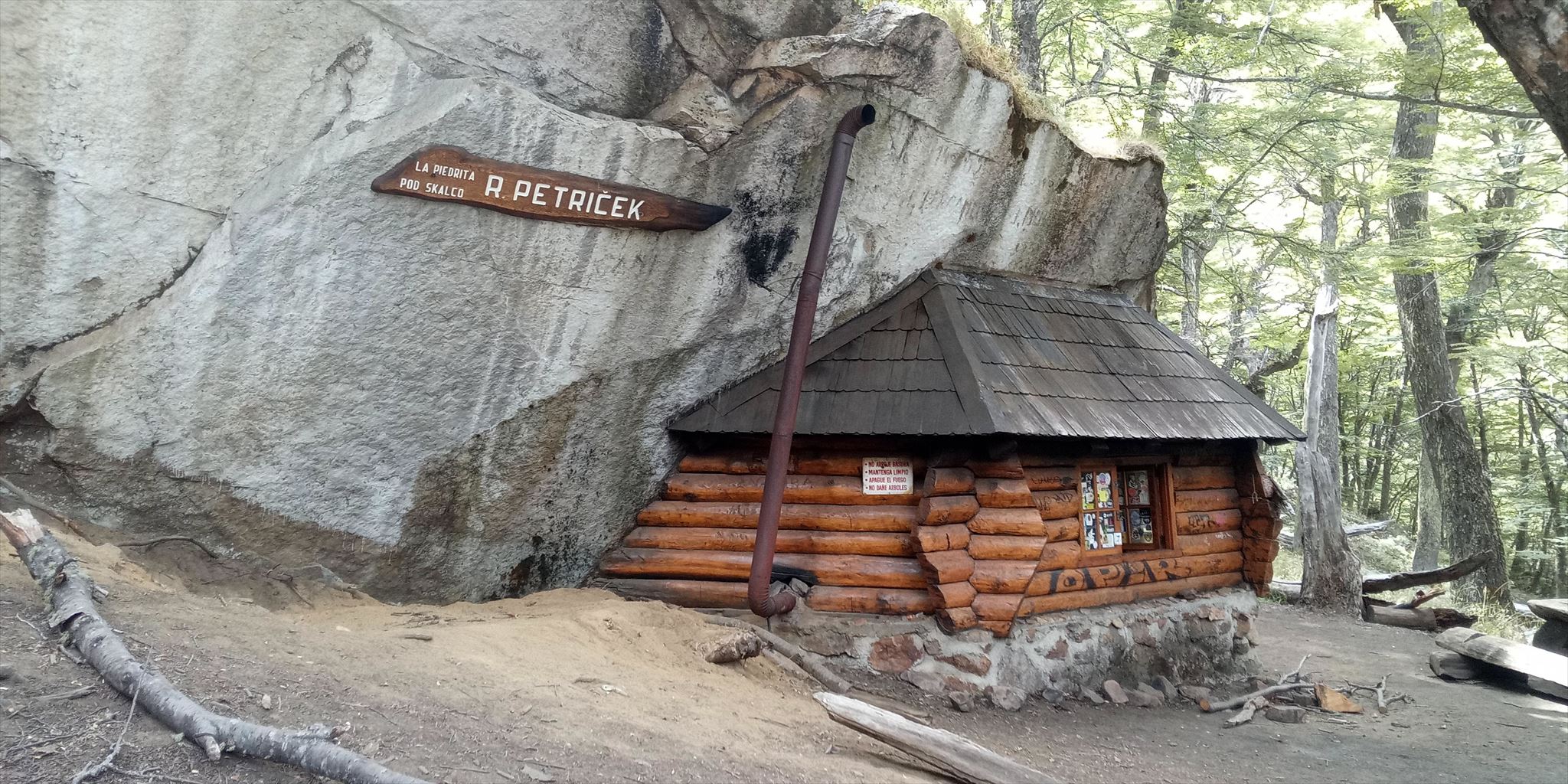
REFUGIO PETRIČEK / PIEDRITAS
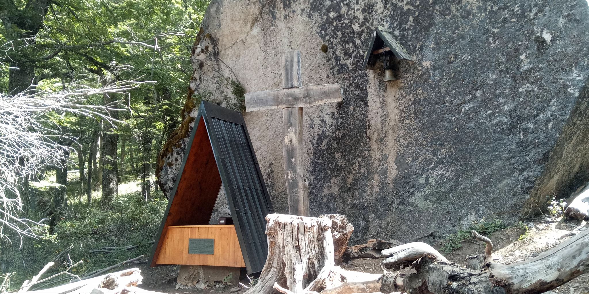
No hay mucho que decír de este refugio. Apartenece al Club Andino Esloveno y es una pequeña y muy linda cabina pegada a un bloque errático. Está en la ruta hacia el refugio Frey, y no está habilitado para pernoctar por el peligro de hantavirus de los roedores que la habitan. En realidad, el refugio está vandalizado y solo es apto para parar fuera y descansar un rato. Cerca del refugio hay otro bloque errático con una cruz y una placa dedicada a un personaje esloveno. Hay que buscar el caché ahí. Ten en cuenta que las coordenadas no son muy precisas debido a que mi GPS no es de los mejores y el lugar se encuentra en un bosque. Si obtienes una mejor lectura, no dudes en compartirla conmigo para que pueda actualizar el listado.

OVERVIEW
This geocache is part of a small series dedicated to an excellent traverse ideal for experienced hikers who are looking for both a technical and a physical challenge. The traverse, off-limits during winter, is 46 km long, it connects the four most emblematic huts of the Nahuel Huapi National Park and it usually takes 3-4 days to complete (each hut has its own access route from town, so the hike can be split into stages). Overnights are at the staffed huts (booking and payment required) or at adjacent camping sites (free).

For detailed info about the trail, maps, gps track, hut booking, guides and national park registration form (compulsory), please visit Barilochetrekking.com (in English). Guides can also be hired through the many tourist agencies in town. Experienced hikers should have no problem tackling the trail on their own, but some sections are not as well marked and could be tricky with bad visibility. Some steep rocky sections become slippery and are off-limits during rainy weather. Also note that the traverse is accessible only during summer-time (roughly December-April).
TRAIL DESCRIPTION
Although the traverse can be done in both directions, it is highly recommended and much safer, due to the various steep sections on loose ground, to start at Cerro Catedral ski resort (bus n. 55 from Bariloche). From here, the trail heads up to the Emilio Frey Hut (GC8MNKK) along its traditional route (half-way up you can take a break near the tiny hut Refugio Petricek, managed by the Slovenian Andine Club. Sadly, this cute tiny place is no longer functional). It then continues on to Schmoll Lagoon (GC8MNKB), close to the Cathedral Peaks ridge, from where it descends steeply down to the valley of the Rucaco creek and, after a short spell inside a peaceful forest, it climbs up to the Brecha Negra ridge and again very steeply down to the Jakob Lagoon and San Martín Hut (spacious and modern).
From here, a slightly technical scramble (off-limits during wet weather) leads up to the "Ridge of Innocents" (Cordon de los inocentes), then through a gap (GC8MNM0) with views of Laguna Navidad, round the "glacial circle" and up to "Christmas Peak" (Cerro Navidad, 2093 m). What follows is an even steeper descent into the valley, where the trail joins the approach from Colonia Suiza, and up the switchbacks (El Caracol, GC1PQ4C - not my cache) to the romantically candle-lit, rustic hut on the shores of Laguna Negra, with the nicest camping spots.
From here, another climb up to the Bailey Willis (1950 m), down to the Goye creek basin (where cows pollute the water source) and up again on loose and extremely steep scree to the Lopez ridge (near Pico Turista, 2070 m, GC8MNKT) with spectacular 360° views of Cerro Tronador, Lago Nahuel Huapi and several peaks in Chile, including Volcán Osorno and Cerro Puntiagudo. Finally, the traverse will punish you with a taxing descent on rocks smoothed by thousands of feet down to the last hut, refugio López, where it turns into a 4x4 track (with dusty shortcuts) that'll spit you out onto the paved road of the "Small loop" (Circuito Chico) near the Colonia Suiza turnoff. Parking and public transport are available.
REFUGIO PETRICEK / PIEDRITAS
There isn't much to say about this hut. It belongs to the Slovenian Andean Club and it's a cute little cabin attached to a glacial erratic. You'll find it on the way to the Frey hut, and it's not allowed to stay here overnight due to the danger of hantavirus carried by rodents that inhabit the place. In fact, the hut is vandalized and is only suitable for a quick stop outside. Near the hut there is another glacial erratic with a cross and a plaque dedicated to a Slovenian character. Look for the cache there. Keep in mind that the coordinates are not very accurate because my GPS is not the best and the place is in a forest. If you get a better reading, feel free to share it with me so I can update the listing.

VŠEOBECNÝ POPIS
Tato minisérie keší je věnována excelentnímu horskému přechodu vhodnému pro zkušené trekkery, kteří si potrpí na technické i fyzické výzvy. Je přístupný jen v létě, měří 46 km, spojuje čtyři nejikoničtější chaty národního parku Nahuel Huapi a obvykle trvá 3–4 dny (ke každé chatě vede samostatný trek a přechod tak lze rozdělit na víc částí). Nocuje se v zařízených chatách s personálem (nutná rezervace a poplatek), nebo se lze utábořit poblíž (zdarma).
Podrobné informace o trase, mapy, gps souřadnice, kontakt na průvodce a link na registrační formulář parku (povinný) najdete na Barilochetrekking.com (v angličtině a španělštině). Průvodce lze najmout také v některé z mnoha agentur ve městě. Zkušení trekkeři by přechod měli bez problémů zvládnout sami, avšak některé úseky nejsou moc dobře značené a za špatné viditelnosti mohou být značně obtížné. Některé strmé kamenné úseky jsou za deštivého počasí zakázány. Dále mějte na vědomí, že se jedná o letní trek, přístupný pouze od prosince do dubna.
POPIS TRASY
Ačkoliv je přechod možný obousměrně, kvůli četným strmým úsekům na sypkém povrchu je mnohem lepší a bezpečnější vyrazit z lyžařského střediska Cerro Catedral (z centra Bariloche sem jezdí autobus 55), kde začíná tradiční stezka k chatě Frey (GC8MNKK). Na půli cesty si můžete orazit u miniaturního srubu Refugio Petriček, patřící Slovinskému Andskému Klubu. Tento roztomilý miniaturní srub je už bohužel nefunkční). Trasa dále vede okolo laguny Schmoll (GC8MNKB) blízko špičatého hřebenu Catedral a klesá po strmém úbočí do údolí potoka Rucaco. Po krátké procházce klidným lesem stoupá na další hřeben – Brecha Negra – a opět velmi prudce klesá k laguně Jacob a chatě San Martín (moderní a prostorné).
Následuje výstup mírně technického rázu (za deštivého počasí zakázaný) na „Hřeben nevinných“ (Cordon de los inocentes), přehoupnutí se přes hřeben skrze průrvu (GC8MNM0) s výhledem na lagunu Navidad, „ledovcový oblouk“ a konečně krátký výstup na „Vánoční vrch“ (Cerro Navidad, 2093 m). Odtud stezka pokračuje zatím nejstrmějším klesáním a v údolí se napojuje na přístupovou cestu z Colonia Suiza v místě zvaném Caracol (GC1PQ4C – cizí keška). Caracol je série serpentin vinoucích se několik set výškových metrů k rustikální, svíčkami osvětlené a romanticky působící chatě na břehu Laguna Negra, kde se nachází také nejhezčí tábořiště.
Další etapa začíná výstupem na vrch Bailey Willis (1950 m), sestupem do údolí potoka Goye (místní zdroj vody bývá znečištěn krávami) a nejdrsnějším výstupem celé trasy po extrémně strmém a kamenitém úbočí až na hřeben Lópezu (poblíž Pico Turista, 2070 m, GC8MNKT), nabízející spektakulární 360° výhledy na Cerro Tronador, na jezero Nahuel Huapi a na několik chilských vrchů, včetně sopky Osorno a Cerro Puntiagudo. Nakonec vás přechod ztrestá sestupem po hladké, tisíci podrážkami vyleštěné skále k poslední chatě, refugio López, kde se stezka změní na offroadovou silnici (s prašnými zkratkami pro pěší) a konečně vás vyplivne u asfaltového okruhu Circuito Chico, kde lze zaparkovat a u nedaleké odbočky na Colonia Suiza chytit autobus.
REFUGIO PETRIČEK / PIEDRITAS
O této chatě toho není moc co říci. Patří Slovinskému Andskému Klubu a jedná se o malý, roztomilý srub připlácnutý na bludný balvan. Nachází se na cestě k chatě Frey a není dovoleno zde nocovat kvůli nebezpečí hantaviru, který šíří místní hlodavci. Ve skutečnosti je chata zdevastovaná a vhodná pouze ke krátké zastávce venku. Kousek od chaty se nachází další bludný balvan s křížem a pamětní deskou věnovanou jedné slovinské osobnosti. Kešku hledejte tam. Mějte na paměti, že souřadnice nejsou příliš přesné, protože moje GPS není z nejlepších a místo se nachází v lese. Kdybyste naměřili přesnější polohu, klidne se o ni podělte a já listing aktualizuji.