The cache container is a small Lock&Lock type container. The LLPCR must be the portal where missing keys go, because like the other "Key" caches in the area, this cache contains a bunch of keys. Our keys always seem to go missing, maybe yours do to, and maybe one of these is a key that you have lost. If one of them looks like your lost key feel free to take it. No need to trade. Just take what you need. Happy to help. The cache is by the shore, in an old charred and rotting stump. This one may push the limits of winter friendly (we've seen hides like this get frozen in on occasion), so hopefully you don't need your missing key until spring thaw.
A map of the Loyhead Lake Primitive Canoe Route (LLPCR) can be found here. A pamphlet describing the Canoe Route can be obtained from the Washburn County Forestry office and probably from the Washburn County Visitor's Center in Spooner.
This area of the Washburn County Forest is also criss-crossed by ATV/snowmobile trails. There is also a network of county forest "roads" and walking trails, though it can be difficult at times to determine where the "roads" and "trails" start and the forest begins. The Washburn County Forest Map linked below may help navigate the trails in the area:
Birchwood Canoe Primitive Area (north) Area 25b
Notes on Attributes:
- We did our very best to make this cache "winter friendly", but there's nothing about a winter with 6 feet of snow that can be construed as "friendly", and that's a bit out of our control. Sometimes caches get frozen in place. Please try not to do too much damage extracting a frozen cache.
- If you're out in the winter, snowshoes maybe the best way to go, but that's really up to you. Just a suggestion.
- Hiking distances will obviously vary depending upon the route selected, and the time of year (cutting across on the ice (use extreme care when attempting to walk on (frozen) water) can shorten the trip).
- It's northern Wisconsin, of course there are ticks, thorns, mosquitoes, flies and poison ivy (in the summer). Another cache in paradise.
- Terrain is given a 4 because the trails and "forest roads" back here can be kind of maze like and some moderate bushwhacking will probably be necessary.
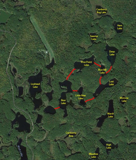
Image from Google Maps
Loyhead Lake Primitive Canoe Route (LLPCR)
Loyhead Lake Primitive Canoe Route is located in southeastern Washburn County, Wisconsin. The area is approximately 23 miles east of Spooner and 8 miles north of Birchwood. The Loyhead Lake access is 1 mile north of the Sawmill Primitive Campground, operated by the Washburn County Forestry Department and offering 25 campsites.
The LLPCR lies within the Washburn County Forest. The area is heavily forested with rolling topography. A unique feature of this area is the high density of small land-locked glacial lakes with steep banks and wooded shores. Large mouth bass and panfish are the major game fish.
A canoe portage and trail system has been marked to guide canoeists to many of the area lakes. You can travel by canoe or kayak to at least 7 different lakes using the portages, most under 200 yards long, and additional lakes not currently connected to the portage system can be explored. (Map of Loyhead Lake Primitive Canoe Route)
The Sawmill Lake Primitive Canoe Route just to the south provides access to 9 lakes.