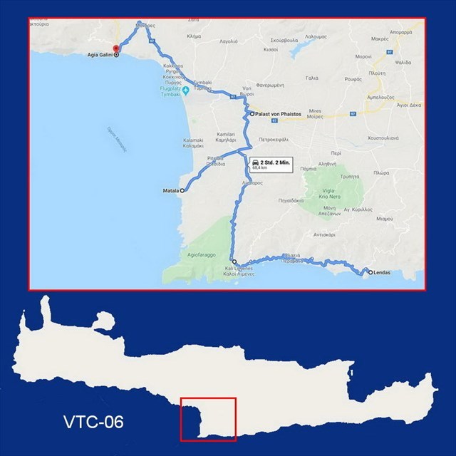
VTC-06: Virtual Trip to Crete (68 km)
Lentas – Agia Galini
***** Deutsch? - Bitte nach unten rollen! *****
***** Ελληνικά; - Προς τα κάτω, παρακαλώ! *****
This cache is part of the series „Virtual Trip to Crete“.
All information concerning the series here:
"VTC: Virtual Trip to Crete"
In time of Corona you may follow all the instructions of the listing virtually using Google Street View. This way no need to visit live all the tour stops to calculate the final's coordinates. Only for signing the logbook you should schedule a visit on Crete as soon as the Corona crisis is behind us.
The sixth stage of the "Virtual Trip to Crete" takes us from Lentas along a small side road along the south coast to the west and then via Matala and Phaistos to Agia Galini.
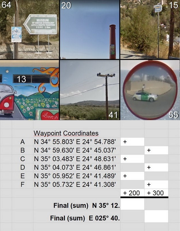
At waypoint A, we have just left Lentas and there are still 15 km ahead of us until we see the impressive rock of Trafos lying off the coast.
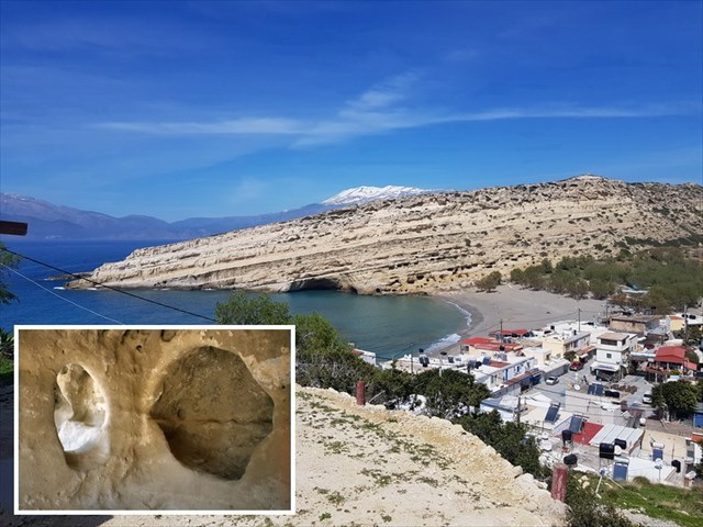
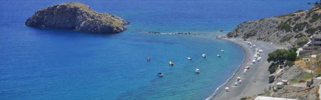
A short detour to Matala is a must when you are in the area. You don't have to tell my generation about the Matala myth.
For the others: In the Neolithic period (5500 to 2200 BC) numerous caves were dug into the soft, porous rock of the bay, to live in. Later during the Roman occupation of Crete they were used as burial sites. In the 1960s, hippies from all over the world (including many young US citizens who refused to take part in the Vietnam War) settled in the Neolithic caves in the rock face north of the beach and founded a large community there. At times Joni Mitchell lived here.
A photo was taken by a geocacher at waypoint B, which he uploaded to the cache “Herby - Matala Beach Festival” (https://coord.info/GC82H9V) added to his found log. A section of this photo can be found among the six pictures that are to be assigned to the correct waypoints.
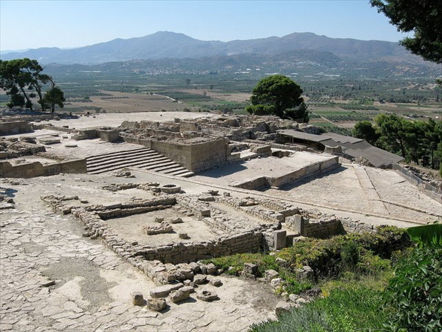
At waypoint C, we turn off the main road to Phaistos to look at the excavation site of the Minoan settlement.
More: https://en.wikipedia.org/wiki/Phaistos
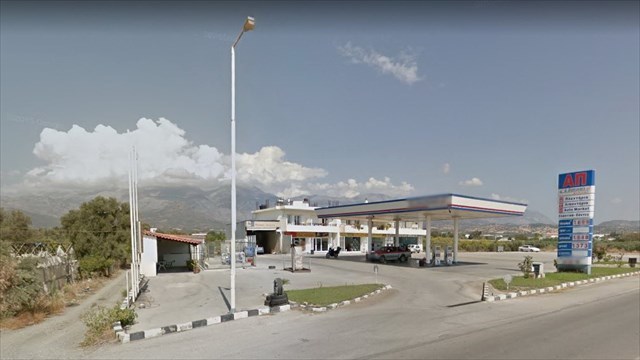
Our previous cache car worked with LPG and a few years ago there were only a few petrol stations all over South Crete where you could fill up with LPG. While traveling in this area, we made sure that we reached in time at waypoint D the only petrol station within a radius of about 100 km where LPG was sold.
(Google Street View was here in 2014, so the gas system on the left is still under construction.)
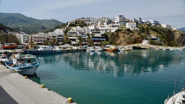
To Agia Galini you are driving downwards in many curves and just late - at waypoint E - the small port of Agia Galini appears below us.
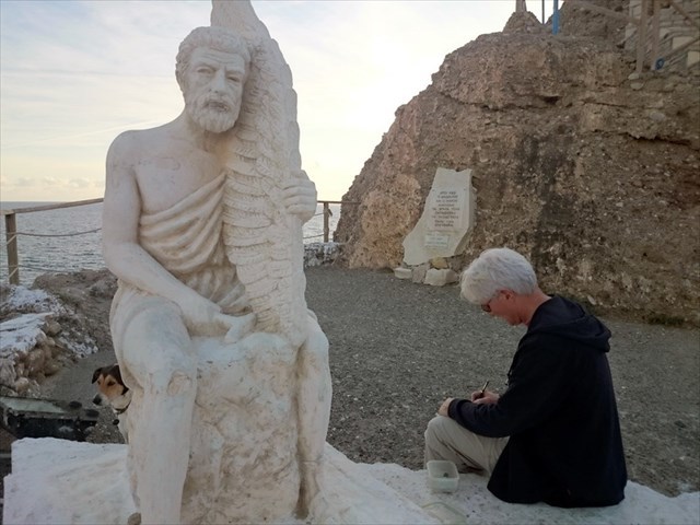
Agia Galini is closely related to Greek mythology. Here the dramatic flight of Icarus and Daedalus from the wrath of King Minos took place. A rock on the west side of the village served as a launch site for their flight towards the sun. At this point, the community erected a monument overlooking the bay of Agia Galini in honor of the two legendary figures. If you stand at the harbor at waypoint F, you can see the monument from far.
We found the geocache "Daedalos & Ikaros" owned by Kreizweh here in November 2014.
If you go virtually to these six waypoints and if you look around there, you will easily identify the following six pictures to calculate the final's coordinates:
Check your coordinates with certitude and get an additional spoiler picture:

… and now proceed on your „Virtual Trip to Crete“:
VTC-07: Agia Galini – Plakias
Have a good virtual trip and see you soon on Crete!
***** Deutsch *****
Dieser Cache ist Teil der Serie „Virtual Trip to Crete“.
Alle Informationen zur Serie erfahrt ihr hier:
"VTC: Virtual Trip to Crete"
Allen Anweisungen dieses Listings könnt Ihr in Zeiten von Corona virtuell mit Google Street View folgen, so dass Ihr nicht tatsächlich vor Ort sein müsst, um die Finalkoordinaten zu berechnen. Nur das Signieren des Logbuchs müsst Ihr auf den Tag verschieben, an dem Ihr real nach Kreta reisen werdet.
Die Bilder im Text schaut Euch bitte in der englischen Beschreibung an!
Die sechste Etappe des „Virtual Trip to Crete“ bringt uns von Lentas über eine kleine Nebenstraße an der Südküste entlang nach Westen und dann über Matala und Phaistos nach Agia Galini.
Bei Wegepunkt A haben wir gerade Lentas hinter uns gelassen und es liegen noch 15 km vor uns, bis wir – real gefahren – nach etwa einer Dreiviertelstunde links den imposanten Felsen Trafos vor der Küste liegen sehen.
Ein kleiner Abstecher nach Matala ist ein Muss, wenn wir schon hier in der Gegend sind. Meiner Generation muss man zum Mythos Matala nichts erzählen.
Für die anderen: In der Jungsteinzeit (5500 bis 2200 v. Chr.) wurden in das weiche, poröse Gestein der Bucht zahlreiche Wohnhöhlen gegraben, die in der Zeit der römischen Besetzung Kretas als Grabstätten genutzt wurden. In den 1960er Jahren siedelten sich in den neolithischen Wohnhöhlen in der Felswand nördlich des Strandes Hippies aus aller Welt an (darunter viele junge US-Bürger, die ihre Teilnahme am Vietnamkrieg verweigerten), und gründeten dort eine große Kommune. Zeitweise lebte hier auch Joni Mitchell.
Am Wegepunkt B wurde von einem Geocacher ein Foto aufgenommen, das er bei seinem Found-Log zum Cache „Herby – Matala Beach Festival“ (https://coord.info/GC82H9V) hochgeladen hat. Ein Ausschnitt aus diesem Foto findet sich unter den sechs Bildern, die den richtigen Wegepunkten zugeordnet werden sollen.
Bei Wegepunkt C biegen wir von der Hauptstraße nach Phaistos ab, um uns dort die Ausgrabungsstätte der Siedlung aus minoischer Zeit anzusehen.
Mehr dazu hier: https://de.wikipedia.org/wiki/Phaistos
Unser früheres Cache-Mobil fuhr mit Autogas und vor wenigen Jahren noch gab es in ganz Südkreta nur vereinzelt Tankstellen, wo man Autogas tanken konnte. Wenn wir hier unterwegs waren, rechneten wir immer genau aus, dass wir am Wegepunkt D zur einzigen Gas-Tankstelle im Umkreis von fast 100 km kamen.
Google-Street-View war 2014 hier, daher ist links im Bild die Gasanlage noch im Bau.
Nach Agia Galini fährt man steil in vielen Kurven hinunter und erst spät – am Wegepunkt E – taucht der kleine Hafen von Agia Galini unter uns auf.
Agia Galini ist eng mit der griechischen Mythologie verbunden. Hier spielte sich die dramatische Flucht des Ikarus und Daedalus vor dem Zorn des Königs Minos ab. Ein Felsen auf der Westseite des Dorfes diente als Startplatz für ihren Flug gegen die Sonne. An dieser Stelle errichtete die Gemeinde ein Denkmal mit Blick auf die Bucht von Agia Galini zu Ehren der beiden Sagengestalten. Wer unten am Hafen bei Wegepunkt F steht, kann das Denkmal schon von weitem sehen.
Den Geocache „Daedalos & Ikaros“ von Kreizweh fanden wir hier im November 2014.
Wenn Ihr Euch an den sechs oben genannten Wegepunkten virtuell umschaut, werdet Ihr leicht sechs Bilder identifizieren können, die oben im englischen Listing bzw. in der Bildergalerie zu sehen sind. Dort findet Ihr auch das Rechenblatt das Euch zu den Finalkoordinaten führt.
Kontrolliert Eure Final-Koordinaten mit certitude und Ihr erhaltet ein zusätzliches Spoiler-Bild:
… und auf folgendem Streckenabschnitt könnt Ihr virtuell weiterreisen:
VTC-07: Agia Galini – Plakias
Gute virtuelle Reise und bis bald wieder live auf Kreta!
***** Ελληνικά *****
Συνήθως η ελληνική έκδοση έρχεται πρώτη στις περιγραφές μου.
Αυτή η σειρά απευθύνεται κυρίως στους φίλους μας από το εξωτερικό.
Ως εκ τούτου, θα βρείτε την ελληνική έκδοση κατ 'εξαίρεση στο τέλος της λίστας.
Εντάξει;
Αυτό το geocache ανήκει στη σειρά „Virtual Trip to Crete“.
Όλες τις λεπτομέρειες της σειράς θα τις μάθετε εδώ:
"VTC: Virtual Trip to Crete"
Σε περιόδους Corona, μπορείτε να ακολουθήσετε όλες τις οδηγίες αυτής της περιγραφής με το Google Street View, έτσι μην χρειάζεται να είστε πραγματικά στην περιοχή για να υπολογίσετε τις συντεταγμένες του φινάλε. Απλώς πρέπει να αναβάλλετε την υπογραφή του ημερολογίου μέχρι την ημέρα που πραγματικά θα ταξιδέψετε στην Κρήτη.
Τις εικόνες για το κείμενο μπορείτε να τις βρείτε στην αγγλική περιγραφή!
Το έκτο τμήμα του "Virtual Trip to Crete" μας πάει από το Λέντας σε μικρό πλάγιο δρόμο κατά μήκος της νότιας ακτής προς τα δυτικά και έπειτα μέσω των Ματάλων και της Φαιστού προς την Αγία Γαλήνη.
Στο Σημείο Διαδρομής Α μόλις βγήκαμε από το Λέντας και έχουμε ακόμα 15 χιλιόμετρα μπροστά μας μέχρι να δούμε στα αριστερά τον εντυπωσιακό βράχο, τον Τράφο, ένα νησάκι που βρίσκεται κοντά από την ακτή.
Μια παράκαμψη στα Μάταλα είναι απαραίτητη όταν βρισκόμαστε στην περιοχή. Δεν χρειάζεται να πείτε στη γενιά μου για τον μύθο των Ματάλων.
Για τους άλλους: Στη νεολιθική εποχή (5500 - 2200 π.Χ.), πολλές σπηλιές φτιάχτηκαν στον μαλακό, πορώδη βράχο του κόλπου για να ζουν οι άνθρωποι μέσα. Κατά τη ρωμαϊκή κατοχή της Κρήτης χρησιμοποιήθηκαν ως τόποι ταφής. Στη δεκαετία του '60, οι χίπις από όλο τον κόσμο (συμπεριλαμβανομένων πολλών νέων Αμερικανών πολιτών που αρνήθηκαν να λάβουν μέρος στον πόλεμο του Βιετνάμ) εγκαταστάθηκαν στις νεολιθικές σπηλιές στον βράχο, βόρεια της παραλίας και ίδρυσαν μια μεγάλη κοινότητα εκεί. Κάποτε έζησε και η Joni Mitchell εδώ.
Μια φωτογραφία πήρε ένα geocacher στο Σημείο Διαδρομής B, που την έβαλε μαζί με το «found-log» του στο cache του "Herby - Matala Beach Festival" (https://coord.info/GC82H9V). Ένα τμήμα αυτής της φωτογραφίας μπορεί να βρεθεί ανάμεσα στις έξι εικόνες που πρέπει να αντιστοιχιστούν στα σωστά Σημεία Διαδρομής.
Στο Σημείο Διαδρομής C, θα στρίψουμε από τον κεντρικό δρόμο προς τη Φαιστό για να κοιτάξουμε τον ανασκαφικό χώρο του μινωικού οικισμού.
Περισσότερα εδώ: https://el.wikipedia.org/
Το προηγούμενο cache-mobile μας δούλευε με υγραέριο και πριν από λίγα χρόνια υπήρχαν μόνο λίγα βενζινάδικα σε όλη τη Νότια Κρήτη, όπου θα μπορούσατε να γεμίσετε με υγραέριο. Κάνοντας εκδρομές σε αυτή την περιοχή προσέχαμε καλά να φτάνουμε στην ώρα μας στο Σημείο Διαδρομής D στο μοναδικό βενζινάδικο σε ακτίνα περίπου 100 χλμ, που πουλούσε υγραέριο τότε.
Το Google Street View ήταν εδώ το 2014, οπότε το σύστημα υγραερίου στα αριστερά είναι ακόμα υπό κατασκευή.
Για την Αγία Γαλήνη κατεβαίνουμε σε πολλές στροφές και αργά - στο Σημείο Διαδρομής E - το μικρό λιμάνι του Άγια Γαλήνη εμφανίζεται κάτω από μας.
Η Αγία Γαλήνη συνδέεται στενά με την ελληνική μυθολογία. Εδώ έλαβε χώρα η δραματική πτήση του Ικάρου και του Δαίδαλου από την οργή του βασιλιά Μίνωα. Ένας βράχος στη δυτική πλευρά του χωριού χρησίμευσε ως χώρος εκτόξευσης για την πτήση τους στον ήλιο. Σε αυτό το σημείο, η κοινότητα έφτιαξε ένα μνημείο με θέα στον κόλπο της Αγίας Γαλήνης προς τιμήν των δύο θρυλικών μορφών. Αν είστε στο λιμάνι στο Σημείο Διαδρομής F, μπορείτε να δείτε το μνημείο από μακριά.
Βρήκαμε το geocache "Daedalos & Ikaros" από τον Kreizweh εδώ τον Νοέμβριο του 2014.
Ρίξτε μια εικονική ματιά στα έξι Σημεία Διαδρομής που προαναφέρθηκαν και θα μπορείτε εύκολα να εντοπίσετε τις έξι εικόνες που τις βλέπετε στην αγγλική λίστα παραπάνω ή στην γκαλερί εικόνων. Εκεί θα βρείτε επίσης το υπολογιστικό φύλλο που θα σας οδηγήσει στις συντεταγμένες του φινάλε.
Ελέγξτε την λύση σας μεcertitudeκαι θα πάρετε μια επιπλέον φωτογραφία «spoiler»:
… και συνεχίσετε το «Virtural Trip to Crete» με την παρακάτω τμήμα διαδρομής:
VTC-07: Agia Galini – Plakias
Να έχετε ένα καλό εικονικό ταξίδι και θα σας δούμε ζωντανά σύντομα στην Κρήτη!