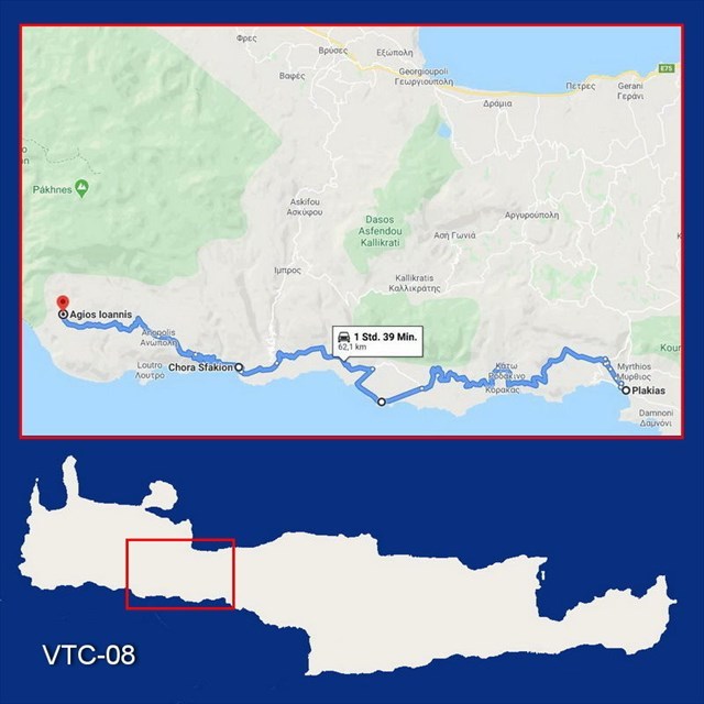
VTC-08: Virtual Trip to Crete (62 km)
Plakias – Chora Sfakion – Ag. Ioannis
***** Deutsch? - Bitte nach unten rollen! *****
***** Ελληνικά; - Προς τα κάτω, παρακαλώ! *****
This cache is part of the series „Virtual Trip to Crete“.
All information concerning the series here:
"VTC: Virtual Trip to Crete"
In time of Corona you may follow all the instructions of the listing virtually using Google Street View. This way no need to visit live all the tour stops to calculate the final's coordinates. Only for signing the logbook you should schedule a visit on Crete as soon as the Corona crisis is behind us.
There is a special place to go today: Alonia Guest House in the mountain settlement Agios Ioannis at 800 m altitude at the foot of the Lefka Ori, the white mountains. On our trip starting from Plakias we will experience a great variety.
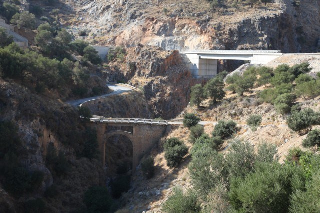
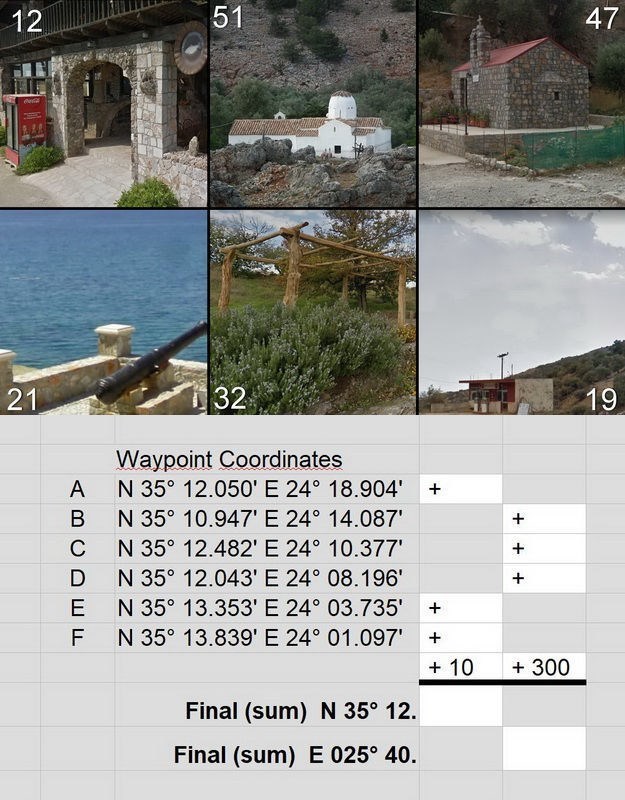
First we stop in the village of Rodakino at waypoint A to see the bridge structures from then and now.
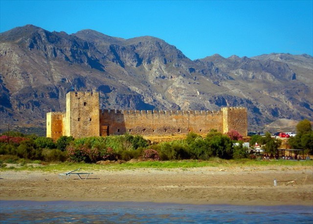
At waypoint B in the Frangokastelo fortress, the legend says that the Drosoulites should appear as shadows on the beach, at the end of May with the first morning dew. Drosoulites are the souls of the dead warriors who died at the Battle of Frangokastello in May 1828. Many visitors claim to have really seen the Drosoulites. Maybe, because there is a scientific explanation that these shadows could arise from reflections of sunlight in the morning dew. It is said here with a grin that during the period when the Germans occupied Crete, a German patrol claimed to have seen the spirits and opened fire on them. In any case, the Drosoulites were never photographed.
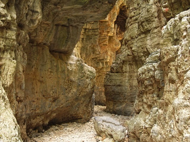
We postpone the walk through the Imbros Gorge until we physically re-enter the island of Crete. Then we can park at waypoint C at the bottom of the gorge if we want to hike the gorge upwards.
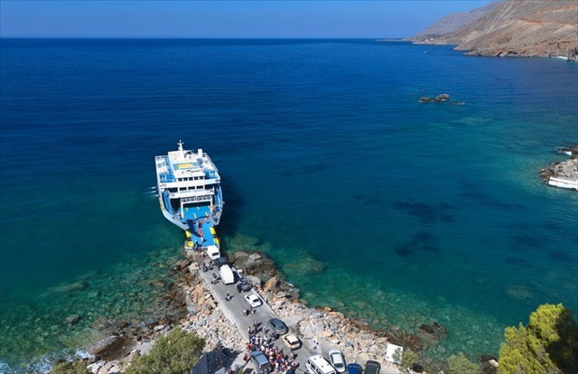
Chora Sfakion (waypoint D) has a special meaning as a small ferry port. From here you can take a ferry, that also transports cars, to the villages of Loutro or Agia Roumeli at the exit of the Samaria Gorge. But also the small island of Gavdos, 40 km off the coast of Crete at the southernmost point of Europe in the sea, is supplied from here with the ferry connection.
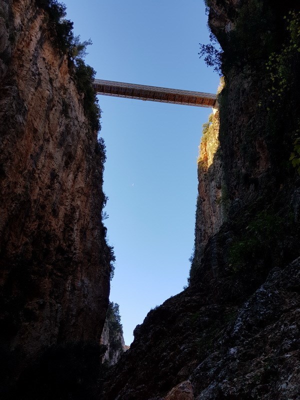
From Chora Sfakion we now drive with many serpentines into the mountains and cross at waypoint E the steel bridge that leads over the Aradena Gorge. Geocachers were standing in the middle of the bridge when they took their photo, which they left together with their found log at the cache "Aradena" (https://coord.info/GC1J1E9) from Wind & Wasser. A part of this photo is used to calculate the final coordinates of this puzzle.
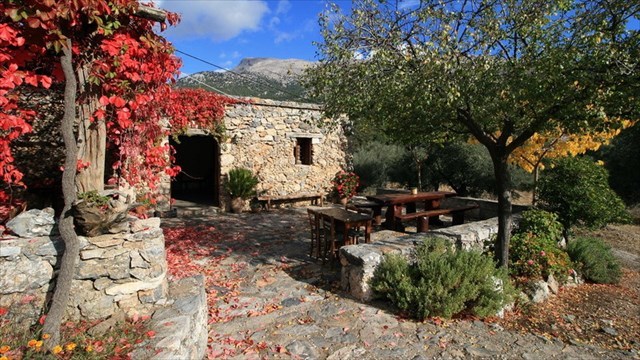
I suggest that at the end of the day at waypoint F we stay for two or three nights at Alonia Guest House with the flair of a small alpine club hut, what you won't find anywhere else on Crete. In seclusion in a beautiful mountain landscape with wonderful GC walks all around. In any case, we ourselves come regularly. We also like to go there in winter time when in all of the rooms the wood fire in the stoves is burning.
Details: https://www.alonia.gr/
If you go virtually to these six waypoints and if you look around there, you will easily identify the following six pictures to calculate the final's coordinates:
Check your coordinates with certitude and get an additional spoiler picture:

… and now proceed on your „Virtual Trip to Crete“:
VTC-09: Ag. Ioannis – Samaria Gorge – Paleochora
Have a good virtual trip and see you soon on Crete!
***** Deutsch *****
Dieser Cache ist Teil der Serie „Virtual Trip to Crete“.
Alle Informationen zur Serie erfahrt ihr hier:
"VTC: Virtual Trip to Crete"
Allen Anweisungen dieses Listings könnt Ihr in Zeiten von Corona virtuell mit Google Street View folgen, so dass Ihr nicht tatsächlich vor Ort sein müsst, um die Finalkoordinaten zu berechnen. Nur das Signieren des Logbuchs müsst Ihr auf den Tag verschieben, an dem Ihr real nach Kreta reisen werdet.
Die Bilder im Text schaut Euch bitte in der englischen Beschreibung an!
Heute haben wir ein besonderes Ziel, die kleine Herberge Alonia in der Bergsiedlung Agio Ioannis auf 800 m Höhe am Fuss der Lefka Ori, der weissen Berge. Unsere Fahrt von Plakias dorthin wird recht abwechselungsreich werden.
Zunächst halten wir bei dem Örtchen Rodakino am Wegepunkt A an, um uns die Konstruktionen von Brücken einst und jetzt anzusehen.
Am Wegepunkt B, bei der Festung Frangokastelo, sollen der Sage nach Ende Mai mit dem ersten Morgentau die Drosoulites als Schatten am Strand erscheinen. Drosoulites sind die Gespenster der toten Krieger, die bei der Schlacht von Frangokastello im Mai 1828 fielen. Viele Besucher behaupten, wirklich die Drosoulites gesehen zu haben. Mag sein, denn es gäbe eine wissenschaftliche Erklärung, dass diese Schatten durch Spiegelungen des Sonnenlichts im Morgentau entstehen könnten. Gern wird hier erzählt, dass in der Zeit, als die Deutschen Kreta besetzt hielten, eine deutsche Patrouille die Gespenster gesehen haben will und das Feuer gegen sie eröffnete. Fotografiert wurden die Drosoulites jedenfalls noch nie.
Das Durchwandern der Imbros Gorge verschieben wir auf die Zeit, wo wir wirklich wieder unseren Fuss auf die Insel Kreta setzen. Dann können wir am Wegepunkt C, am unteren Ende der Schlucht, parken, wenn wir die Schlucht hinaufsteigen wollen.
Chora Sfakion (Wegepunkt D) hat als kleiner Fährhafen eine besondere Bedeutung. Von hier aus kann man mit einer Fähre, die auch Autos transportiert, zu den Orten Loutro oder Agia Roumeli am Ausgang der Samaria-Schlucht gelangen. Aber auch die kleine Insel Gavdos, die 40 km vor der Küste Kretas am südlichsten Punkt Europas im Meer liegt, wird von hier aus mit der Fährverbindung versorgt.
Von Chora Sfakion aus fahren wir nun in vielen Serpentinen hinauf in die Berge und überqueren bei Wegepunkt E die Stahlbrücke, die über die Aradena-Schlucht führt. Mitten auf der Brücke haben Geocacher gestanden, als sie ihr Foto schossen, das sie zusammen mit ihrem Found-Log bei dem Cache „Aradena“ (https://coord.info/GC1J1E9) von wind&water gelassen haben. Ein Ausschnitt aus diesem Foto wird gebraucht, um die Finalkoordinaten dieses Mysteries zu berechnen.
Ich schlage vor, dass wir uns am Ende des Tages bei Wegepunkt F für zwei oder drei Nächte in der Herberge Alonia mit dem Flair einer kleinen Alpenvereinshütte einmieten, weil so kann man Kreta nirgends sonst erleben. In Abgeschiedenheit in einer herrlichen Gebirgslandschaft mit wunderbaren GC- Wanderungen rund herum. Wir kommen jedenfalls regelmäßig. Auch im Winter fahren wir gern dorthin, wenn in jedem Gästehäuschen das Holzfeuer im Kaminofen brennt.
Details: https://www.alonia.gr/
Wenn Ihr Euch an den sechs oben genannten Wegepunkten virtuell umschaut, werdet Ihr leicht sechs Bilder identifizieren können, die oben im englischen Listing bzw. in der Bildergalerie zu sehen sind. Dort findet Ihr auch das Rechenblatt das Euch zu den Finalkoordinaten führt.
Kontrolliert Eure Final-Koordinaten mit certitude und Ihr erhaltet ein zusätzliches Spoiler-Bild:
… und auf folgendem Streckenabschnitt könnt Ihr virtuell weiterreisen:
VTC-09: Ag. Ioannis – Samaria Gorge – Paleochora
Gute virtuelle Reise und bis bald wieder live auf Kreta!
***** Ελληνικά *****
Συνήθως η ελληνική έκδοση έρχεται πρώτη στις περιγραφές μου.
Αυτή η σειρά απευθύνεται κυρίως στους φίλους μας από το εξωτερικό.
Ως εκ τούτου, θα βρείτε την ελληνική έκδοση κατ 'εξαίρεση στο τέλος της λίστας.
Εντάξει;
Αυτό το geocache ανήκει στη σειρά „Virtual Trip to Crete“.
Όλες τις λεπτομέρειες της σειράς θα τις μάθετε εδώ:
"VTC: Virtual Trip to Crete"
Σε περιόδους Corona, μπορείτε να ακολουθήσετε όλες τις οδηγίες αυτής της περιγραφής με το Google Street View, έτσι μην χρειάζεται να είστε πραγματικά στην περιοχή για να υπολογίσετε τις συντεταγμένες του φινάλε. Απλώς πρέπει να αναβάλλετε την υπογραφή του ημερολογίου μέχρι την ημέρα που πραγματικά θα ταξιδέψετε στην Κρήτη.
Τις εικόνες για το κείμενο μπορείτε να τις βρείτε στην αγγλική περιγραφή!
Ο προορισμός μας σήμερα είναι ένα ιδιαίτερο μέρος: Ο Ξενώνας Αλώνια στον ορεινό οικισμό Άγιος Ιωάννης σε υψόμετρο 800 μ. στους πρόποδες των Λευκών Ορέων. Το ταξίδι μας από τον Πλακιά μας πάει σε κάποια ωραία σημεία.
Πρώτα σταματάμε κοντά στο χωριό Ροδάκινο στο Σημείο Διαδρομής Α για να δούμε τις τεχνολογίες κατασκευής της γέφυρας τότε και τώρα.
Με τον όρο Δροσουλίτες είναι γνωστό ένα οπτικό φαινόμενο που παρατηρείται γύρω από το Φραγκοκάστελλο (Σημείο Διαδρομής Β). Παρατηρείται σχεδόν κάθε χρόνο μεταξύ Μαΐου και Ιουνίου κατά τις πρωινές ώρες. Πρόκειται για κινούμενες σκιές που παρατηρούνται στον κάμπο του Φραγκοκάστελλου, από τις γύρω ορεινότερες περιοχές. Το όνομά τους έχει να κάνει με την εμφάνισή τους κατά τις πρωινές ώρες, μαζί με την πρωινή δροσιά. Η τοπική παράδοση συνδέει το φαινόμενο με τη φονική μάχη που διεξήχθη στην περιοχή τον Μάιο του 1828 ανάμεσα στους εξεγερμένους κατοίκους της περιοχής και σε τουρκικό στρατιωτικό σώμα. Οι πιο αποδεκτές επιστημονικά εξηγήσεις αποδίδουν το φαινόμενο σε αντικατοπτρισμό ή σε οφθαλμαπάτη.
Λέγεται εδώ με ευχαρίστηση ότι κατά την περίοδο κατά την οποία οι Γερμανοί κατέλαβαν την Κρήτη, μια γερμανική περίπολος ισχυρίστηκε ότι είχε δει τα πνεύματα και τους άνοιξε πυρ. Σε κάθε περίπτωση, οι Δροσουλίτες δεν φωτογραφήθηκαν ποτέ.
Αναβάλλουμε τη βόλτα στο φαράγγι του Ίμπρου μέχρι πραγματικά να επιστρέψουμε στο νησί της Κρήτης. Τότε μπορούμε να σταθμεύσουμε στο Σημείο Διαδρομής C στο κάτω μέρος του φαραγγιού αν θέλουμε να ανεβαίνουμε το φαράγγι προς τα πάνω.
Το μικρό Λιμάνι της Χώρας Σφακίων έχει ιδιαίτερη σημασία (Σημείο Διαδρομής D). Από εδώ μπορείτε να πάρετε πλοίο, το οποίο επίσης μεταφέρει αυτοκίνητα, στα χωριά Λουτρό ή Αγία Ρούμελη, στην έξοδο του φαραγγιού της Σαμαριάς. Kαι το μικρό νησί της Γαύδου, 40 χλμ. από την ακτή της Κρήτης στο νοτιότερο σημείο της Ευρώπης, τροφοδοτείται από εδώ με τη σύνδεση με το φέρι.
Από τη Χώρα Σφακίων οδηγούμε τώρα σε πολλές στροφές στα βουνά και διασχίζουμε στο Σημείο Διαδρομής Ε την ατσάλινη γέφυρα που οδηγεί πάνω από το φαράγγι της Αράδαινας. Οι Geocacher βρέθηκαν στη μέση της γέφυρας όταν έβγαλαν τη φωτογραφία τους, την οποία άφησαν μαζί με το found-log τους στο geocache "Aradena" (https://coord.info/GC1J1E9) των wind&water. Ένα τμήμα αυτής της φωτογραφίας χρησιμοποιείται για τον υπολογισμό των συντεταγμένων του φινάλε αυτού του παζλ.
Στο τέλος της ημέρας προτείνω να μείνουμε στο Σημείο Διαδρομής F για δύο ή τρεις νύχτες στο Ξενώνα Αλώνια με την αίσθηση μιας μικρής αλπικής καλύβας, αυτό που δεν θα βρείτε πουθενά αλλού στην Κρήτη. Σε απομόνωση σε ένα πανέμορφο ορεινό τοπίο με υπέροχους περιπάτους GC παντού. Οπωσδήποτε, εμείς οι ίδιοι το επισκεπτόμαστε τακτικά. Μας αρέσει επίσης να πηγαίνουμε εκεί το χειμώνα όταν σε όλα τα δωμάτια η φωτιά στις ξυλόσομπες καίει.
Λεπτομέρειες: https://www.alonia.gr/
Ρίξτε μια εικονική ματιά στα έξι Σημεία Διαδρομής που προαναφέρθηκαν και θα μπορείτε εύκολα να εντοπίσετε τις έξι εικόνες που τις βλέπετε στην αγγλική λίστα παραπάνω ή στην γκαλερί εικόνων. Εκεί θα βρείτε επίσης το υπολογιστικό φύλλο που θα σας οδηγήσει στις συντεταγμένες του φινάλε.
Ελέγξτε την λύση σας με certitude και θα πάρετε μια επιπλέον φωτογραφία «spoiler»:
… και συνεχίσετε το «Virtural Trip to Crete» με την παρακάτω τμήμα διαδρομής:
VTC-09: Ag. Ioannis – Samaria Gorge – Paleochora
Να έχετε ένα καλό εικονικό ταξίδι και θα σας δούμε ζωντανά σύντομα στην Κρήτη!