Welcome to the Myette Beach Strip Barrier
It is commonly accepted that the beach strip (barrier) on which you are standing due to the erosion of the headlands to your east and west. Wave action carried the erosional debris thanks in large part due to the onshore north westerly winds working to form a sandbar. As debris was further dropped through Longshore (Littoral) Drift, the sandbar continued to grow in length, and littoral drift from wind moved the sand further up the shoreline, plants started to take hold, stabilizing the bar and a spit began to form. As the spit continued to grow, it eventually adjoining the headlands creating a Barrier which cut off the flow of water from St. George’s Bay into Tracadie Harbour to the south.
Longshore, or Littoral Drift is the process by which material is moved along a beach by a prevailing current, where waves break at an angle to the shoreline (moving parallel) within the surf zone. Longshore Drift is the material waves and wind work to shape coastlines, depositing and rearranging the sand, rock, gravel, bits of shell, and other debris to form shoals, spits, bars, barriers and beaches.
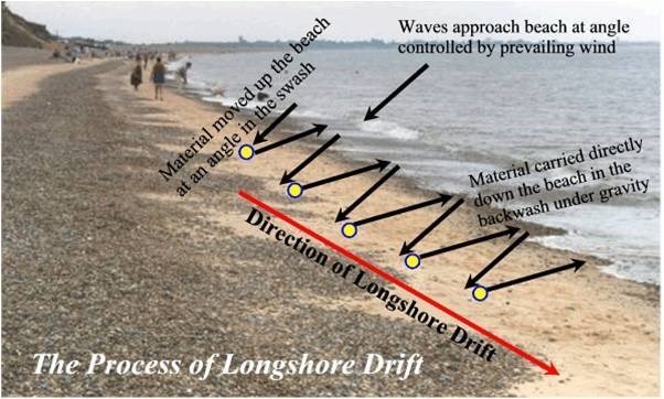
Once the bar began to develop on the western side of the beach, the spit and eventually the barrier was quick to get established, as opposing waves moving in from the west portion of St. George’s Bay, broke along the barrier, continuing to drop debris and provided Longshore Drift on the north side of the barrier. Continuing wave action, from the west - erosion of the shoreline and Longshore Drift continue to allow for the growth and evolution of the Myette Beach Strip.
Logging Requirements:
In order to log this EarthCache, you will be required to do some exploration, read the information provided above, visit the related webpage, and make observations of the surrounding area. Please submit the answers to the following questions through my profile. Any “Found it” log without answers submitted to the CO, demonstrating your understanding, will be deleted.
-
Standing at the Posted Coordinates, measure the length of the Myette Beach Strip Barrier. You may use the distance between the parking coordinates for geocaches: GC8MJ3R, and GC8MJ23 on either end of the Myette Beach Strip Barrier.
-
At the posted coordinates, provide your observations of the wave actions [movement of debris] on the Beach Strip Barrier. If you arrive in the winter and it is iced in, use your understanding learned in this geocache to predict what they would be.
-
Judge the width of the Myette Beach Strip Barrier at the posted coordinates. Go on to N 45 38.687 W 061 38.977. Do you notice anything different at this location as compared to the posted cache coordinates? Please describe the topography… i.e.) trees and vegetation, width of the strip barrier. Is the strip barrier in jeopardy of opening up here? Why?
-
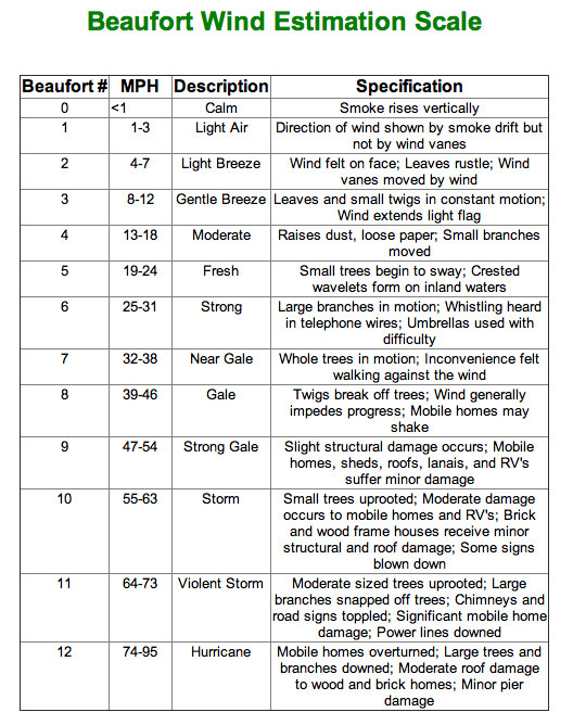
Please determine the wind-speed and direction during your visit. Wind speed and wind direction can be found using the website https://www.windfinder.com/forecast/tracadie
If you have your own anemometer, you are of course welcome to use that. Please also use the Beaufort Wind Estimation Scale, found below, to describe the wind based on the speeds given in the scale.
5) At the time of your visit, describe what you observe happening, to further build the barrier separating Tracadie Harbour from St. George’s Bay. Describe any observations you notice of Longshore Drift, both looking west and east. Would ice in the winter contribute?
6) Please post two photos of yourself with the bay in the background in one, and the harbour in the background for another. Please take time to explore the entire beach and the other two nearby earthcaches.