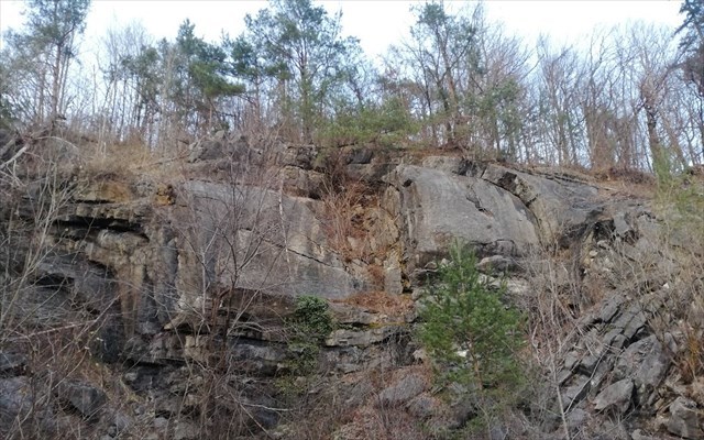
Kuclerjev kamnolom/ Kucler's quarry (foto: Emahana)
Kuclerjev kamnolom se imenuje več kamnolomov črnega apnenca pri Lesnem Brdu. V njem so več kot 150 let kopali gradbeni material, imenovan »črni marmor«. Posebej dragocen je bil za izdelavo bogatih in slikovito obdelanih portalov. Kamnolom, ki ga po nekdanjem lastniku imenujemo Kuclerjev kamnolom je bil leta 1991 razglašen za naravni geološki spomenik.
Nahaja se na obronku Ljubljanskega barja med Brezovico in Vrhniko, v vasi Lesno Brdo na nadmorski višini okoli 350 m. V kamnolomu, kjer so v preteklih stoletjih kopali črni in sivi apnenec se menjavajo plasti temno sivega do črnega mikritnega apnenca in tankoplastnega skrilavega laporovca ter muljevca. Drobno zrnati sedimenti in številna favna dokazujejo, da je sedimentacija potekala v plitvi laguni, ki je na tem območju obstajala v karniju, to je pred približno 225 milijoni let. Plastičnost sedimentov in močni tektonski premiki pa so povzročili, da se je kamnina kasneje nagubala, posledično je danes v delu kamnoloma ohranjena izrazita guba, kjer so se kamnine karbonske starosti narinile na mlajše kamnine triasne starosti. Kamnina je bila zaradi lepega črno-belega kontrasta (rezultat kalcitnih žilic v apnencu), ki daje kamnini še prav posebno dekorativno vrednost, vedno cenjena kot arhitektonski kamen. Zato ni naključje, da so ga že pred desetletji uporabljali kot dragocen naravni kamen za izdelavo številnih arhitekturnih členov, ki so ostali vgrajeni v domove okoliških prebivalcev kot del bogate kamnoseške tradicije tega kraja. Plasti apnenca so različno debele, med njimi pa najdemo tudi do 70 cm debele plasti premoga antracita in črni skrilavi lapor. Prav zaradi lečastega pojavljanja premogovih teles v kamnolomu ni prišlo do večjega odkopavanja, saj apnenec zaradi tega slabše kljubuje zunanjim vremenskim pogojem.
V kamnolomu je postavljen tudi geološki stolpec, ki prikazuje kamnine širšega območja, nekoliko stran pa stojijo nekateri kipi, ki so jih na mednarodnem kiparskem simpoziju izdelali različni umetniki.
V Ljubljani lahko vidimo več kamnitih izdelkov, katerih material izhaja iz tega kamnoloma, med drugimi Vodnjak treh kranjskih rek (Robbov vodnjak) kjer je kot obelisk nad vodnjakom uporabljen rožasti lesnobrdski apnenec, posoda vodnjaka, stopnice in stebrički pa so iz sivega lesnobrdskega apnenca, kipa dveh gigantov na portalu semenišča, »Črni kralj« v cerkvi sv. Jakoba …
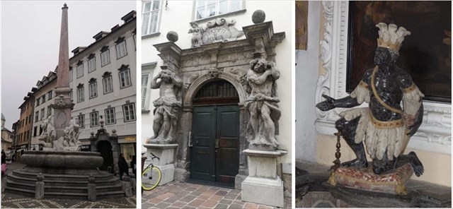
(1)Vodnjak treh kranjskih rek Robbov vodnjak pred Mestno hišo/ The fountain of the three Carniolan rivers Robb's fountain in front of the Town Hall (foto : Emahana), (2)Herkulesa na portalu semenišča/Hercules on the seminary portal (foto: Emahana), (3)Črni kralj/Black king (foto: Valentin Benedik ZVKDS RC)
Kuclerjev kamnolom, ki sodi med bisere slovenske geološke znamenitosti, je danes poznan po izredno lepem primeru tektonske gube in po bogatem nahajališču fosilnih školjk in drugih mikrofosilov.
TEKTONSKE GUBE
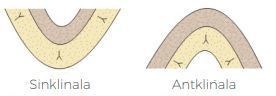
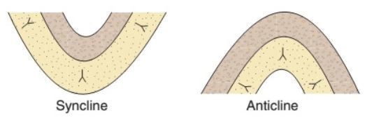
Na tektonski gubi v kamnolomu je dobro viden izbočen antiklinalni del in vbočen sinklinalni del. Proti nam so obrnjene plošče krila gube, ki so v spodnjih stenah kamnoloma navpično odrezane. Kamnina je enakomerno upognjena, kar kaže, da so se plasti gubale v plastičnem ali polplastičnem stanju.
Antiklinala guba je konveksna v smeri mlajših plasti, v jedru gube pa nastopajo starejše plasti, sinklinala guba pa je konveksna v smeri starejše plasti, v jedru gube pa nastopajo mlajše plasti.
Geometrijo gub praviloma analiziramo v normalnem ali tektonskem profilu gube, ki je pravokoten na os gubanja. V profilu gube ločimo krili gube in pregib gube. Pregib je lahko oster ali postopen. V pregibu ima nagubana ploskev največjo ukrivljenost.
Tudi krili gube sta pogosto ukrivljeni; prehod iz konveksne v konkavno obliko krila imenujemo prevojna točka.

Geometrija gube
Orientacijo gube opisujemo glede na njeno os in osno ploskev. Pri orientaciji osi je guba lahko vodoravna, toneča ali navpična, pri orientaciji osne ploskve pa je guba lahko pokončna, nagnjena ali polegla.
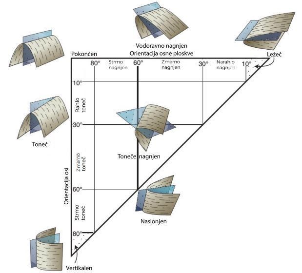
Orientacija gube
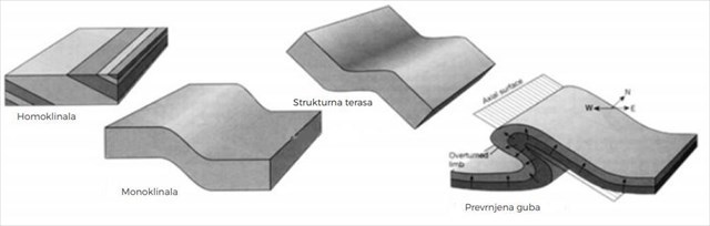
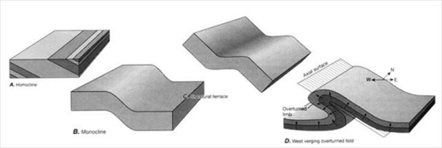
Po razvitosti in medsebojni orientaciji kril lahko definiramo naslednje tipe gub:
- homoklinala – plasti, ki vpadajo pod določenim kotom, brez pregiba
- monoklinala – horizontalni krili, povezani s kratkim poševnim odsekom
- strukturna terasa – poševni krili, povezani s kratkim horizontalnim odsekom
- prevrnjena guba – nagnjena guba, ki ima eno krilo rotirano v inverzno lego (prevrnjeno krilo)
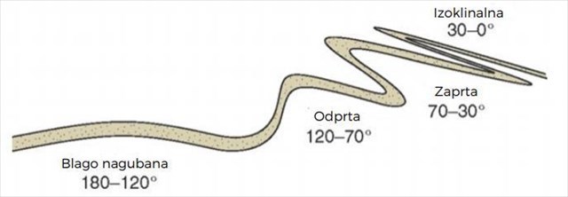
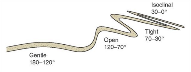
Odprtost gube definiramo s pomočjo kota med kriloma gube:
- blago nagubane gube: 180°do 120°
- odprte gube: 120°do 70°
- zaprte gube: 70°do 30°
- izoklinalne gube: 30°do 0°(krili sta vzporedni)
FOSILI
V kamnolomu so prisotni številni fosilni ostanki, ki jih najdemo v apnencih, v plasteh vmesnega črnega premoga in v plasteh skrilavega laporja. Prav makrofosili so tisti, po katerih je kamnolom postal znan. Celotna družba je živela v zaprti do pol-zaprti plitvi laguni skupaj s kalcitnimi algami. Školjke so se popolnoma ali delno zakopavale v takratno blatno dno in danes imajo velikokrat ohranjeni obe lupini, ki sta lahko odprti ali zaprti. Školjke nastopajo v obliki kamenih jeder, ali pa so vidne kot preseki v apnencu. V laporju, običajno tik nad apnenčevim skladom, so cele školjčne preproge z 12 vrstami in podvrstami rodu Trigonodus ter s tremi podvrstami rodu Myophoria z značilnimi od vrha proti sprednjemu robu vzdigujočimi grebeni. Kaže, da je moralo biti precej laporja raztopljenega in so zato nastala tolikšna nakopičenja školjk prav v tem delu. V črnem lesnobrdskem apnencu pa so komaj omembe vredni okameneli polži, še manj pa je koral. V karnijskih plasteh kamnoloma pa lahko opazimo tudi fosilne sledove ali ihnofosile. To so biološko povzročene sedimentne teksture, ki vključujejo sledi, rove, izvrtanine, fekalne pelete in druge sledove, ki so jih povzročili organizmi. Ihnofosili v kamnolomu se imenujejo thalassinoides in so fosilizirani rovi (sistemi kanalov) rakov in rib.
Morska favna in flora sta bogati tudi na mikronivoju, saj so bile določene številne vrste foraminifer, mikrogastropodov, holoturij (iglokožci z zakrnelim notranjim skeletom) in alg. V kamnolomu je najbolj prepoznavna združba treh foraminifernih rodov: Lamelliconus, Aulotortus in Triadodiscus.
Mikrofosili
- alge klipeine (Clypeina besici) – velikosti nekaj desetink milimetra
- foraminfere
- trohilina (rod Trocholina)
Makrofosili
- školjke:
- kranjski trigonod (Trigonodus carniolicus)
- kefersteinova mioforija (Myophoria kefersteini)
- rugozna srčanka (Pachycardia rugosa)
- lofa (Lopha montiscaprillis)
POMEMBNO!
Pazite na naravo in je ne poškodujte! Vsak je odgovoren za svoja dejanja.
Za vpis tega zemeljskega zaklada boste morali najprej odgovoriti na spodnja vprašanja. Odgovore najdete v opisu tega zaklada in na terenu, pošljite jih neposredno na naš e-naslov emahanagc@gmail.com. Takoj potem lahko vpišete obisk zaklada na spletu, ne potrebujete dodatnega dovoljenja.
Vpisi brez ustrezne spremljajoče e-pošte ali vpisi, ki vsebujejo pravilne odgovore bodo brez opozorila izbrisani!
Obisk tega zemeljskega zaklada priporočamo v zimskih mesecih. V poletju je zaradi olistanosti drevja guba slabše vidna. Če pa bi želeli tektonski gubi pogledati neposredno v oči, priporočamo izredno previdnost pri dostopu. Za sam vpis in odgovore plezanje po kamnolomu ni potrebno.
Naloge za vpis:
1. Na koordinatah Geološkega zaklada opazujte TEKTONSKO GUBO.
a. Oceniti debelino posameznih plasti gube.
b. Opišite tektonsko gubo glede na videno na terenu (pomagajte si z opisom zaklada).
2. Na točki FOSILI si oglejte vse stopnice.
a. Koliko stopnic s številnimi makrofosili lahko najdete na tem mestu?
b. Na katere oblike, ki jih srečamo v vsakdanjem življenju, vas spominjajo fosilizirane školjke?
3. Na točki AMFITEATER boste zagledali manjši spodmol. Na stropu tega spodmola lahko opazite zanimive kamnite tvorbe. Kaj menite, da bi to lahko bilo?
4. Vpisu, če želite lahko priložite fotografijo, ki pa naj ne razkriva odgovorov na vprašanja.
 Kucler's quarry are called several black limestone quarries near Lesno Brdo. Building material called "black marble" has been mined in it for more than 150 years. It was especially valuable for making rich and picturesquely crafted portals. Kucler's quarry named after its former owner, was declared a natural geological monument in 1991.
It is located on the slope of the Ljubljana Marshes between Brezovica and Vrhnika, in the village of Lesno Brdo at an altitude of about 350 m. In the quarry, where black and gray limestone were mined over the centuries, layers of dark gray to black micrite limestone and thin-layered shale marl and siltstone alternate. The fine-grained sediments and numerous fauna prove that the sedimentation took place in a shallow lagoon that existed in the area in the carnia, that was, about 225 million years ago. Plasticity of sediments and strong tectonic shifts caused the rock to later fold, as a result of which a distinct fold is preserved in part of the quarry today, where Carboniferous rocks pushed on younger rocks of the Triassic age. The stone has always been valued as an architectural stone due to its beautiful black and white contrast (the result of calcite veins in limestone), which gives the stone a very special decorative value. It is therefore no coincidence that it was used as a precious natural stone to make many architectural elements that remained embedded in the homes of the surrounding residents as part of the rich stonemasonry tradition of this place. Layers of limestone vary in thickness, including layers of anthracite coal and black shale marl up to 70 cm thick. Due to the lenticular appearance of coal bodies in the quarry, there was no major excavation, as the limestone is less resistant to external weather conditions.
There is also a geological column in the quarry, showing the rocks of the wider area, and some statues made by various artists at the International Sculpture Symposium stand a little to the side.
In Ljubljana we can see several stone products, the material of which comes from this quarry, including the Fountain of the Three Carniolan Rivers (Robba's Fountain) where the obelisk uses pink limestone, the vessel of the well, the stairs and the pillars are made of gray limestone, a statue of two Hercules of the Seminary Palace portal, "Black King" in the church of St. Jakob…
Kucler's quarry, which is one of the pearls of Slovenian geological sights, is today known for its extremely beautiful example of a tectonic fold and a rich deposit of fossil shells and other microfossils.
TEKTONIC FOLD
The convex anticline part and the concave syncline part are well visible on the tectonic fold in the quarry. Facing us are the panels of the limb of the fold, which are cut vertically in the lower walls of the quarry. The rock is evenly bent, indicating that the layers have folded in a plastic or semi-plastic state.
The anticline fold is convex in the direction of the younger layers, older layers appear in the core of the fold, the syncline fold is convex in the direction of the older layer, and younger layers appear in the core of the fold.
As a rule, the geometry of folds is analyzed in the normal or tectonic profile of the fold, which is perpendicular to the fold axis. In the fold profile, we distinguish the fold limbs and the hinge fold. The hinge can be sharp or gradual. In the hinge, the pleated surface has the greatest curvature.
The limb of the fold are also often curved; the transition from the convex to the concave shape of the limb is called the inflection point.
Geometry of the fold
The orientation of the fold is described with respect to its hinge line and axial surface. In the orientation of the hinge line, the fold can be horizontal, plunging upright or vertical, and in the orientation of the axial surface, the fold can be upright, horizontal inclined or recumbent.
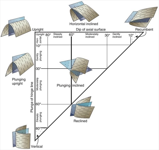
Orientation of the fold
According to the development and mutual orientation of the limb, the following types of folds can be defined:
- homoclinal - layers that fall at a certain angle, without hinge
- monoclinal - horizontal limb connected by a short oblique section
- structural terrace - sloping limb connected by a short horizontal section
- overtuned fold - an inclined fold that has one limb rotated to the inverse position (overturned limb)
The openness of the fold is defined by the angle between the limb of the fold:
- gentle folds: 180°do 120°
- open folds: 120°do 70°
- tight folds: 70°do 30°
- isoclinal folds: 30°do 0°(the wings are parallel)
FOSSILS
Numerous fossil remains which are found in limestone are present in the quarry, in layers of intermediate hard coal and in layers of shale marl. It is the macrofossils that made the quarry famous. The whole society lived in a closed to semi-closed shallow lagoon along with calcite algae. The shells were completely or partially buried in the then muddy bottom and today they often have both shells preserved, which can be open or closed. The shells appear in the form of stone cores, or are visible as cross-sections in limestone. In the marl, usually just above the limestone stack, are whole shell carpets with 12 species and subspecies of the genus Trigonodus and with three subspecies of the genus Myophoria with characteristic ridges rising from the top towards the leading edge. It seems that a lot of marl must have been dissolved and that is why there were so many accumulations of shells in this part. In the black limestone, are however, petrified snails barely worth mentioning, and some corals. Fossil traces or ichnofossils can also be observed in the quarry, in the carnic layers. These are biologically induced sedimentary textures that include traces, tunnels, boreholes, fecal pellets, and other traces caused by organisms. The ichnofossils in the quarry are called thalassinoides and are fossilized tunnels (channel systems) of crustaceans and fish.
Marine fauna and flora are also rich at the micro level, as many species of foraminifers, microgastropods, holothurians (echinoderms with a stunted internal skeleton) and algae have been identified. The quarry is the most recognizable association of three foraminiferal genera: Lamelliconus, Aulotortus and Triadodiscus..
Mikrofossils
- Clypeine algae (Clypeina besici) - the size of a few tenths of a millimeter
- foraminfera
- Trocholina (genus Trocholina)
Makrofossils
- shelss:
- Carniolan trigonod (Trigonodus carniolicus)
- Myophoria kefersteini (Myophoria kefersteini)
- Pachycardia rugosa (Pachycardia rugosa)
- lopha (Lopha montiscaprillis)
IMPORTANT!
Take care of nature and do not damage it! Everyone is responsible for their actions.
In order to log this Earth Cache, you will first need to answer the questions below. You can find the answers in the description of this EC and in the field, send them directly to our e-mail address emahanagc@gmail.com. Immediately after that you can log a visit to the cache online, you do not need additional permission.
Entries without the appropriate accompanying email or entries that contain the correct answers will be deleted without warning!
We recommend a visit to this EC in the winter months. In summer, the fold is less visible due to the foliage of the trees. However, if you would like to look the tectonic folds directly in the eye, we recommend extreme caution when approaching. Climbing the quarry is not necessary for registration and answers.
Your tasks:
1. Observe the TECTONIC FOLD at a point of the earth cache.
a. Estimate the thickness of individual fold layer.
b. Describe the tectonic fold according to what is seen on the field (help yourself with the description of this EC).
2. At the FOSSILS point, look at all the stairs.
a. How many stairs with macrofossils can you find here?
b. On what shape do fosilized shells remind you of from everyday life?
3. At the AMFITEATER point, you will see a small shelter. On the ceiling of this shelter you can see interesting stone formations. What do you think this could be?
4. If you wish, you can attach a photo to your log, but it should not reveal the answers to the questions.
Viri/sources:
https://www.visitvrhnika.si/si/kaj-videti/naravne-znamenitosti/kuclerjev-kamnolom
http://www.dedi.si/dediscina/291-kuclerjev-kamnolom
https://sl.wikipedia.org/wiki/Kuclerjev_kamnolom
https://studentski.net/gradivo/ulj_ntf_ge1_sgt_sno_gube_01
https://studentski.net/gradivo/ulj_ntf_ge1_pal_vaj_ihnofosili_01