
La Earthcache / The Earthcache
► Contexte géologique local
Situé sur la côte orientale, Les marais salés occupent une place prépondérante sur l’île d'Oléron, représentant 20% de la surface insulaire totale.
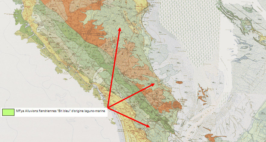
D’après la carte du BRGM, toute la partie sud et sud-est de l’île d'Oléron est occupée par une formation FMya, MFya – « Alluvions flandriennes. Bri bleu ».
► Le Bri Bleu, témoin d’une histoire géologique récente
~ Formation
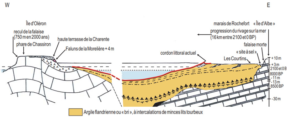
Formée de plateaux calcaires du Crétacé, l'île d'Oléron a connu un phénomène d'érosion pendant la dernière période glaciaire.
Cette érosion a entraîné la formation de vastes dépressions sur Oléron, légèrement penchée vers le Sud-Est, amenant une partie de l'île sous le niveau actuel de l'océan.
A la fin de la dernière glaciation (Würm), la fonte des glaces des inlandsis s'est traduite par une remontée rapide du niveau de la mer, la transgression flandrienne. Cette montée des eaux s'est accompagné d'un comblement accéléré des golfes par des sédiments marins.
Dans les Perthuis et le Coureau d'Oléron, cette sédimentation s'est intensifiée avec d'importants dépôts fluviaux drainés par la Seudre à son embouchure, donnant des formations fluvio-marines d'alluvions flandriennes appelés Bri bleu.
~ Caractéristiques
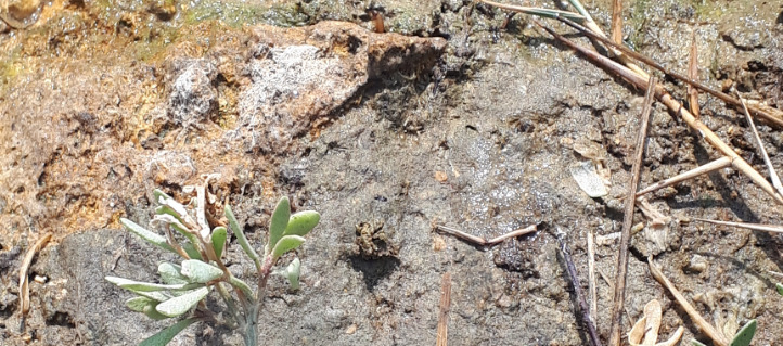
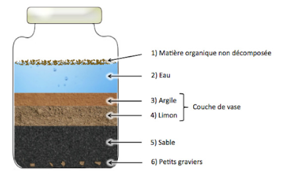
Les alluvions flandriennes sont constitués de bri gris-bleu à débris coquilliers (Lamellibranches, Gastéropodes) et de niveaux lenticulaires de tourbe.
Le bri bleu contient 14% de CaC03. 93 % des particules sont inférieures à 16 micromètres et les argiles représentent environ 55% du matériau.
► Texture d'un sol
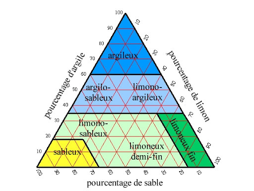
La texture d'un sol est la catégorisation des sédiments le composant selon leur taille (classification granulométrique). Elle s'exprime en proportion de chaque taille d’éléments minéraux : les graviers (> 2 mm) ; les sables (20 µm-0,2 mm) ; les limons (2 µm-20 µm) ; l'argile granulométrique (< 2 µm).
Au delà d'un contrôle visuel, il existe des tests empiriques permettant de déterminer une proportion en argile :
- Au toucher : plus la terre est collante et les mains difficiles à laver, plus la terre est argileuse. Si on ressent beaucoup de « grains » sous les doigts et qu’elle colle peu, alors la terre est peu argileuse.
– Test de la boule et du boudin : On fait rouler un échantillon entre ses mains jusqu’à obtenir une boule, puis on affine cette boule pour en faire peu à peu un cordon et on surveille à quel diamètre ce cordon va casser.
Les observations dépendent de la cohésion de la terre, déterminée par sa teneur en argile, plus le cordon est fin (< 5mm de diamètre), plus il y a d’argile.
► De l'eau de mer au sel, mécanismes physiques et chimiques
Sur Oléron, les marais littoraux ont très tôt dans l'histoire servi à la production de l'or blanc, le sel.
Cette activité a depuis décliné au profit de l'ostréiculture mais reste encore présente sur l'île.
La saliculture utilise trois mécanismes physiques et chimiques pour obtenir cet or blanc au travers d'un circuit faisant appel à une succession de bassins.
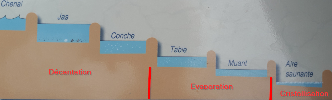
~ Phase 1 : la décantation par sédimentation
La décantation d'une suspension liquide/solide est l'effet de séparation, sous l'effet de la gravitation, de ces deux phases non-miscibles.
Le terme de sédimentation est utilisé quand le liquide chargé n’est soumis qu’à l’action de la pesanteur, notamment en milieu naturel.
Si un liquide contenant des particules en suspension est laissé au repos, les particules tombent vers le fond ou remontent à la surface selon leur densité et leur diamètre, sous l’action combinée de leur poids et de la poussée d'Archimède.
C'est dans le Jas puis la Conche que se fait cette décantation ; l'eau de mer venant du chenal y ait laissé au repos pour permettre la décantation des éléments (coquillages, algues, sable puis limon).
~ Phase 2 : Concentration par évaporation
La Table et le Muant sont des petits bassins peu profonds ou l'eau s'évapore sous l'effet de deux éléments, le soleil et le vent.
La production de sel est donc très dépendante des conditions climatiques.
Ces grands évaporateurs, en réduisant la quantité d'eau, augmente la concentration en sel donnant de la saumure très concentrée (180 grs/l).
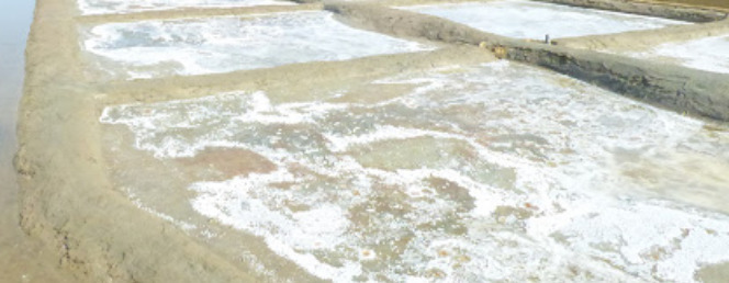
~ Phase 3 : Cristallisation
La saumure entre dans les Aires Saunantes pour la dernière étape.
Dans ces petits bassins très peu profonds, l'eau y poursuit son évaporation et la proportion de sel devient si importante que l'eau n'est plus présente en quantité suffisante pour maintenir tout le sel sous sa forme dissoute et celui-ci forme alors des cristaux : on dit qu'il cristallise.
A 260 grs/l, le sel commence à se cristalliser sous forme solide en chlorure de sodium (NaCl) et peut alors être récolté par le saulnier.
► Local geological context
Located on the eastern coast, the salt marshes occupy a preponderant place on the island of Oleron, representing 20% of the total island surface.
According to the BRGM map, the entire southern and south-eastern part of the island of Oleron is occupied by a formation FMya, MFya - "Alluvions flandriennes. blue Bri ”.
► Le blue Bri, witness to a recent geological history
~ Formation
Formed of Cretaceous limestone plateaus, the island of Oléron experienced erosion during the last ice age. This erosion led to the formation of vast depressions on Oléron, slightly leaning towards the Southeast, bringing part of the island below the current level of the ocean.
At the end of the last glaciation (Würm), the melting of the ice sheets of the ice sheets resulted in a rapid rise in sea level, the Flandrian transgression. This rise in water was accompanied by an accelerated filling of the gulfs with marine sediments.
In the Perthuis and Coureau d'Oléron, this sedimentation intensified with significant river deposits drained by the Seudre at its mouth, giving fluvio-marine formations of Flandrian alluvium called blue Bri.
~ Features
The Flandrian alluvium consists of gray-blue breakage with shell debris (Lamellibranches, Gastropods) and lenticular levels of peat.
The blue bri contains 14% CaC03. 93% of the particles are less than 16 micrometers and the clays represent approximately 55% of the material.
► Texture of a soil
The texture of a soil is the categorization of the sediments composing it according to their size (particle size classification). It is expressed in proportion to each size of mineral elements: gravel and pebbles (> 2 mm); sands (20 µm-0.2 mm); stringers (2 µm-20 µm); particle size clay (<2 µm).
Beyond a visual check, there are empirical tests allowing to determine a clay proportion:
- To the touch: the stickier the soil and the more difficult the hands to wash, the more the clay is clay. If you feel a lot of "grains" under your fingers and it sticks little, then the soil is not very clayey.
- Test of the ball and the sausage: We roll a sample between our hands until we get a ball, then we refine this ball to make a little by little a cord and we monitor to what diameter this cord will break.
Observations depend on the cohesion of the earth, determined by its clay content, the thinner the cord (<5mm in diameter), the more clay there is.
► From seawater to salt, physical and chemical mechanisms
On Oléron, the coastal marshes were used very early in history for the production of white gold, salt.
This activity has since declined in favor of oyster farming but is still present on the island.
Salt production uses three physical and chemical mechanisms to obtain this white gold through a circuit using a succession of basins.
~ Phase 1: settling by sedimentation
The decantation of a liquid / solid suspension is the separation effect, under the effect of gravitation, of these two immiscible phases.
The term sedimentation is used when the charged liquid is only subjected to the action of gravity, especially in a natural environment.
If a liquid containing suspended particles is left to stand, the particles fall to the bottom or rise to the surface depending on their density and diameter, under the combined action of their weight and Archimedes' thrust.
It is in the Jas then the Conche that this settling takes place; the sea water coming from the channel has left there to rest to allow the settling of the elements (shells, algae, sand then silt).
~ Phase 2: Concentration by evaporation
The Table and the Muant are small shallow pools where the water evaporates under the effect of two elements, the sun and the wind.
Salt production is therefore very dependent on climatic conditions.
These large evaporators, by reducing the amount of water, increase the salt concentration giving very concentrated brine (180 grs / l).
~ Phase 3: Crystallization
The brine enters the Saunante Areas for the last stage.
In these small very shallow basins, the water continues to evaporate there and the proportion of salt becomes so large that the water is no longer present in sufficient quantity to keep all the salt in its dissolved form and this then forms crystals: it is said to crystallize.
At 260 grs / l, the salt begins to crystallize in solid form from sodium chloride (NaCl) and can then be harvested by the saulnier.
► Sources bibliographiques / Bibliographical sources
Les Questions / The Questions
La lecture attentive du descriptif de la cache, ainsi qu'une observation des éléments de terrain et un peu de déduction sont normalement suffisants pour répondre aux questions de cette EarthCache.
A careful reading of the description of the cache, as well as observation of terrain features and some deduction is usually sufficient to answer questions of this EarthCache.
Questions pour valider :"Bri bleu et Sel à Oléron"
Questions to validate: "Blue Bri and Salt in Oléron"
- Question 0 : Prenez une photo de vous ou d'un élément vous identifiant avec les salines du Port des Salines en arrière plan.
Cette photo devra au choix nous être transmise avec les réponses ou être ajoutée à votre log.
-Question 0 : TTake a photo of yourself or something identifying you with the salt works of the Port des Salines in the background.
This photo must either be sent to us with the answers or added to your log.
Point 1 : N 45° 51.728 W 001° 13.762
Vous voici devant des instruments météorologiques et un panneau explicatif de 3 facteurs météorologiques influençant la production de sel.
Here you are in front of weather instruments and an explanatory panel of 3 weather factors influencing the production of salt.
- Question 1 : Sur quel phénomène physique agissent les 3 facteurs météorologiques ? Pour chaque facteur, émettez des hypothèses sur son influence dans ce processus.
- Question 1 : What physical phenomenon are the 3 meteorological factors acting on? For each factor, make assumptions about its influence in this process.
- Question 2 : Quelle est la nature des bassins devant vous et leur fonction ?
- Question 2 : What is the nature of the pools before you and their function?
Point 2 : N 45° 51.749 W 001° 13.740
Passez à droite du bâtiment et allez au dernier point d'information. Vous voici devant 6 matières ayant un rôle dans le fonctionnement des salines.
Go to the right of the building and go to the last information point. You are in front of 6 materials having a role in the functioning of the saltworks.
- Question 3 : Identifier les deux éléments géologiques jouant un rôle majeur. Quelles propriétés physico-chimiques de ces deux éléments sont intéressantes dans le processus ?
- Question 3 : Identify the two geological elements playing a major role. What physicochemical properties of these two elements are interesting in the process?
Point 3 : N 45° 51.702 W 001° 13.691
Vous voici devant un mécanisme pouvant pivoter.
You are in front of a mechanism that can pivot.
- Question 4 : Retournez le mécanisme et observez l'évolution du contenu du mécanisme pendant quelques instants. Comment s'appelle ce processus ? Décrivez ce qui se passe. Quelles propriétés des éléments à l'intérieur du mécanisme interviennent dans ce processus ?
- Question 4 : Turn the mechanism over and observe the evolution of the contents of the mechanism for a few moments. What is this process called? Describe what is going on. What properties of the elements inside the mechanism are involved in this process?
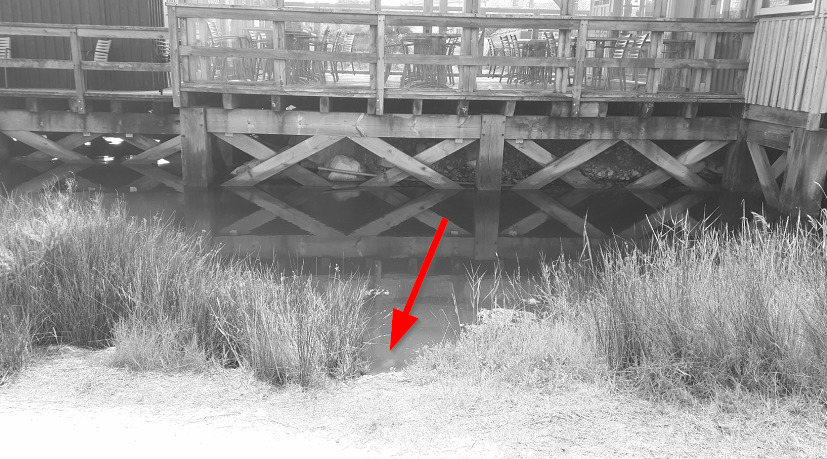
Point 4 : N 45° 51.683 W 001° 13.773
Vous voici au bord d'un jas, mettez vous au bord de l'eau et prenez un peu de sol (photo WP4).
Here you are at the edge of a jas, put yourself at the edge of the water and take a little soil (photo WP4).
- Question 5 : Distinguez-vous les éléments formant ce sol ? Frottez le sol entre vos doigts, que sentez-vous ? Réalisez le test de la boule ou du boudin. Déduisez de vos observations la classe granulométrique et la nature de ce sol.
- Question 5 : Do you distinguish the elements forming this soil? Rub the floor between your fingers, what do you feel? Perform the ball or sausage test. Deduce from your observations the particle size class and the nature of this soil.
- Question 6 : Vos observations du terrain confortent-elles vos réponses à la question 3 ?
- Question 6 : Do your observations from the field confirm your answers to question 3?
Vous pouvez vous loguer sans attendre notre confirmation,
mais vous devez nous envoyer les réponses en même temps soit par mail via notre profil (
fafahakkai), soit via la messagerie geocaching.com (Message Center).
S'il y a des problèmes avec vos réponses nous vous en ferons part.
Les logs enregistrés sans réponses et la photo seront supprimés.
You can log this cache without waiting for our confirmation, but you must send us the answers at the same time, by e-mail via our profile (fafahakkai) or by the system of Message Center of geocaching.com.
If there is a problem with your answers we will notify you. The logs recorded without answers and the photo will be deleted.
Rappel concernant les « Earthcaches »: Il n'y a pas de conteneur à rechercher ni de logbook à renseigner. Il suffit de se rendre sur les lieux, de répondre aux questions ci-dessus et de nous renvoyer les réponses.
Reminder concerning "Earthcaches": there is neither a container to look for nor a logbook to sign. One need only go to the location, answer to the differents questions and send us the answers.