
Earth Science Lesson
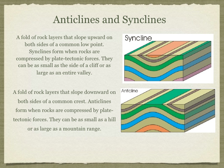
Anticlines are folded rock layers that create an arch. The progressing age of the rock strata towards the core and uplifted center, are the trademark indications for evidence of anticlines on a geologic map. These formations occur because anticlinal ridges typically develop above thrust faults during crustal deformations. The uplifted core of the fold causes compression of strata that preferentially erodes to a deeper stratigraphic level relative to the topographically lower flanks. Motion along the fault including both shortening and extension of tectonic plates, usually also deforms strata near the fault. This can result in an asymmetrical or overturned fold.[1]
An antiform can be used to describe any fold that is convex up. It is the relative ages of the rock strata that distinguish anticlines from antiforms. The hinge of an anticline refers to the location where the curvature is greatest, also called the crest.[1] The hinge is also the highest point on a stratum along the top of the fold. The culmination also refers to the highest point along any geologic structure. The limbs are the sides of the fold that display less curvature. The inflection point is the area on the limbs where the curvature changes direction.[2]
The axial surface is an imaginary plane connecting the hinge of each layer of rock stratum through the cross section of an anticline. If the axial surface is vertical and the angles on each side of the fold are equivalent, then the anticline is symmetrical. If the axial plane is tilted or offset, then the anticline is asymmetrical. An anticline that is cylindrical has a well-defined axial surface, whereas non-cylindrical anticlines are too complex to have a single axial plane.
An overturned anticline is an asymmetrical anticline with a limb that has been tilted beyond perpendicular, so that the beds in that limb have basically flipped over and may dip in the same direction on both sides of the axial plane.[3] If the angle between the limbs is large (70–120 degrees), then the fold is an "open" fold, but if the angle between the limbs is small (30 degrees or less), then the fold is a "tight" fold.[4] If an anticline plunges (i.e., the anticline crest is inclined to the Earth's surface), it will form Vs on a geologic map view that point in the direction of plunge. A plunging anticline has a hinge that is not parallel to the earth's surface. All anticlines and synclines have some degree of plunge. Periclinal folds are a type of anticlines that have a well-defined, but curved hinge line and are doubly plunging and thus elongate domes.[5]

Model of anticline. Oldest beds are in the center and youngest on the outside. The axial plane intersects the center angle of bend. The hinge line follows the line of greatest bend, where the axial plane intersects the outside of the fold.
Folds in which the limbs dip toward the hinge and display a more U-like shape are called synclines. They usually flank the sides of anticlines and display opposite characteristics. A syncline's oldest rock strata are in its outer limbs; the rocks become progressively younger toward its hinge. A monocline is a bend in the strata resulting in a local steepening in only one direction of dip.[2] Monoclines have the shape of a carpet draped over a stairstep.[4]
An anticline that has been more deeply eroded in the center is called a breached or scalped anticline. Breached anticlines can become incised by stream erosion, forming an anticlinal valley.
Logging Tasks
Considering the information above and the formation you are looking at, answer the following questions for credit for this EarthCache.
- What type of anticline are you looking at?
- How can you tell?
- Are the two limbs of the anticline att he same angle? If not which is steeper?
- Take a photo of yourself or a proxy at or near GZ to demonstrate that you visited the site. (Required)
Resources
- Dictionary of Geological Terms (3rd ed.). Garden City, New York: Anchor Press/Doubleday. April 11, 1984. ISBN 978-0-385-18101-3.
- ^ Jump up to:a b c Hefferan, Kevin P. "Folds". Geology 320: Structural Geology. University of Wisconsin–Stevens Point. Retrieved December 8, 2015.
- ^ Mantei, Erwin J. "Geologic Structures—Crustal Deformations". Physical Geology (GLG110). Missouri State University. Retrieved December 17, 2015.
- ^ Jump up to:a b c Marshak, Stephen (2012). Earth: Portrait of a Planet(4th ed.). Norton. ISBN 978-0393935189. Retrieved January 22, 2016.
- ^ Roberts, Albert F. (1947). Geological Structures and Maps: A Practical Course in the Interpretation of Geological Maps for Civil and Mining Engineers. London: I. Pitman. p. 33.
- SPOONER, A. L. E. C. I. A. M. (2020). Geology For Dummies. S.l.: JOHN WILEY.
