The entire stretch of the boardwalk has several rock outcrops that are a part of the Chapman Formation, a thick layer of sandstone held together by calcite originally created at the bottom of a shallow sea over 400 million years ago. In the time since its formation, these rocks have seen quite the transformation. At this Earthcache, you will get to see a cave within the hillside formed by an ancient underwater stream.
Karst Topography
Karst is a type of landscape where the dissolving of the bedrock has created sinkholes, sinking streams, caves, springs, and other characteristic features. Karst is associated with soluble rock types such as limestone and marble. In general, a typical karst landscape forms when much of the water falling onto the surface interacts with and enters the subsurface through cracks and fractures that have been dissolved into the bedrock.
Bedrock is dissolved by natural acid in groundwater that seeps through bedding planes, faults, and joints. Over geological epochs these openings expand as the walls are dissolved to become caves or cave systems. The portions of a solutional cave that are below the water table or the local level of the groundwater will be flooded. After traveling underground, sometimes for long distances, this water is then discharged from springs, many of which are cave entrances.
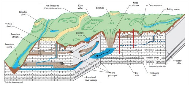
The image below highlights many examples of karst formations, including caves like this one (seen in the center of the diagram). About 20% of the United States is underlain by karst features, and the Knoxville area is almost entirely underlain by its features.
The Cave
It is quite rare to see karst caves exposed along a river like this. Most lay below the surface and only open up as sinkholes. However, the Tennessee River eroded away the side of this hill to expose this cave for us to see.
This cave entrace has loads of evidence pointing towards its history as a former underground stream passage. The smoothed out interior sides of the cave show evidence of groundwater flow that once was completely underground. Also, the length of the cave and connection to other cave systems shows how the river did not create the opening, but rather a long process of erosion into the soluble rock in the region.
Aside from the geology, there is an interesting story behind the namesake of this cave on the sign.
The Earthcache
At GZ, you will be standing just at the entrance to the cave. Please message me your answers to the following questions in addition to your log.
1. What physical evidence suggests that this cave was formed by an underwater stream? (Think erosion.)
2. Consider physical features you have seen in the park and what could be below the surface. What other karst features are present, could be found underground nearby, or even connected to the cave?
3. (Optional) Include a picture of yourself at the listed coordinates in your log.