Soil texture is a classification instrument used by geologists both in the field and laboratory to determine soil classes based on their physical texture. Soil texture can be determined using qualitative methods such as texture by feel, and quantitative methods such as the hydrometer method. Soil texture focuses on the particles that are less than two millimeters in diameter which include sand, silt, and clay. Soil classifications are based on the percentages of sand, silt, and clay in the soil.
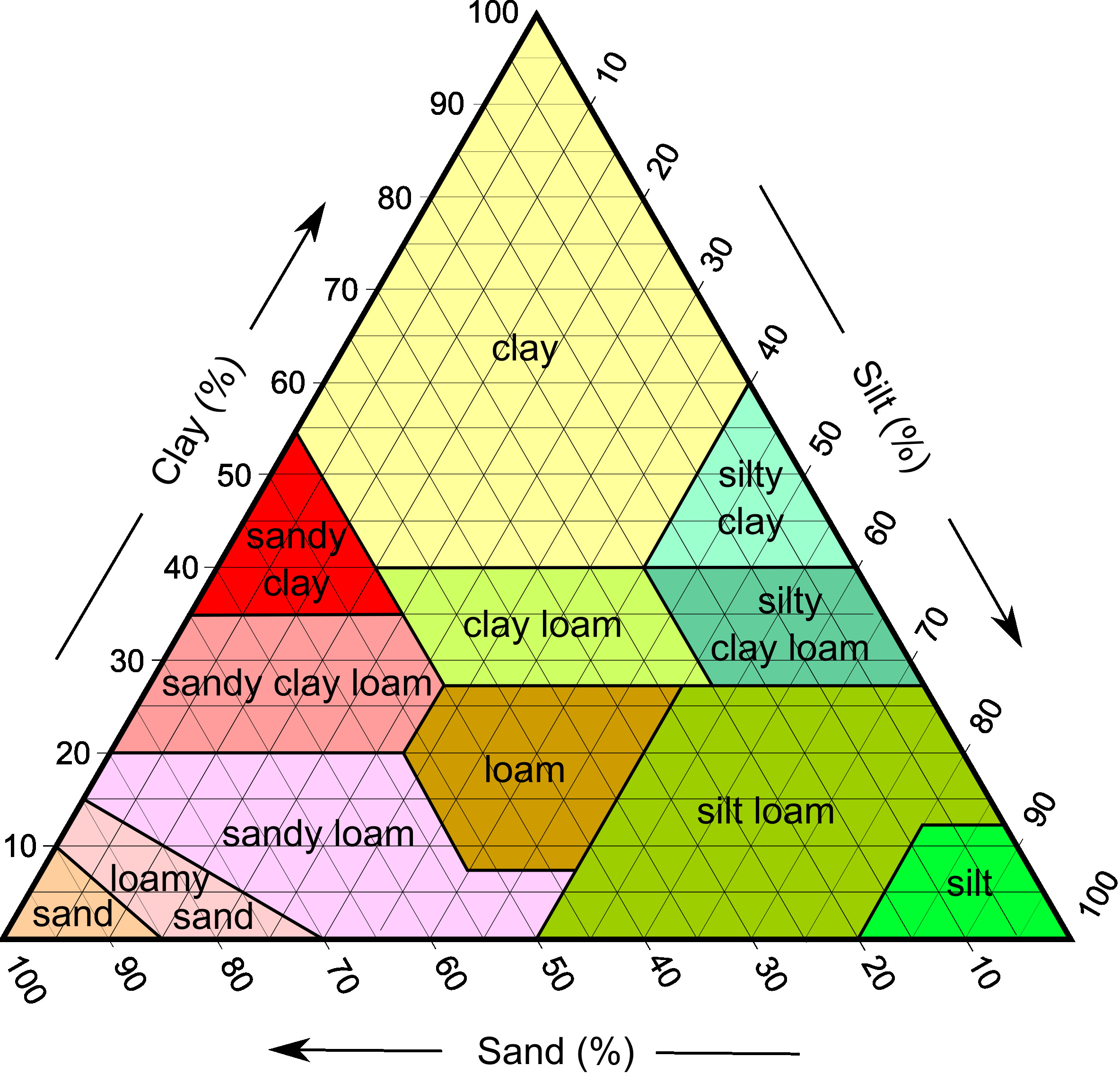
Determining soil texture is often aided with the use of a soil texture triangle. The Soil texture triangle image below shows the major textural classes.
Clay is a finely-grained natural rock or soil material that combines one or more clay minerals with possible traces of quartz, metal oxides, and organic matter. Geologic clay deposits are mostly composed of phyllosilicate minerals containing variable amounts of water trapped in the mineral structure. Clays are plastic due to particle size and geometry as well as water content. Dry clay is more stable than sand in excavations. Clays exhibit plasticity when mixed with water. Depending on the chemical content clay can appear in various colours from white to dull grey or brown to deep orange-red.
Although many naturally occurring deposits clays are distinguished from other fine-grained soils by differences in size and mineralogy. Scientists usually consider the separation to occur at a particle size of 2 μm, clays being finer than silts, which are finer than sand. In South Australia clay deposits were used to manufacture bricks for housing. Most clay deposits are now buried or behind security fences at brickworks.
The geological record on display at Hallet Cove contains a vast layer of Pleistocene clay. The predominately clay with some sand material was deposited about 3 million years ago as run off from the Mount Lofty mountains to the east. The rapid accumulation of clays indicates a much wetter climate than today.
At the cache site you should collect a sample of the soil. You then need to conduct an experiment to check the condition of the soil. You can do the experiment at the cache site or you can take the soil sample home and test there. Please provide the cache owner with answers to the questions listed after the experiment description.
Place your soil sample in a clear container at least 120ml in size. Half filled with soil is about right. Fill the container with clean water. Shake. Shake that thing. Sit the sample down and allow the container to rest for at least 15 minutes. The layers you see are sand, silt, and clay in the soil sample. The bottom layer is sand. The middle layer is silt. The top layer is clay. The clay may take all day to settle. Organic matter will float. Ignore this material.
-Can you see layers in the settled sample? Estimate the percentage of each layer.
-Based on your experiment what is the soil classification at the listed location using the chart?
-What was the colour and texture of the soil sample?
-Estimate the angle of the clay layer? What property of clay produces this angle?