Welcome to a great viewpoint to see the effects of the Cadell Fault on what appears to be grazing land. For a different perspective at water level vist GC30VYH - The Formation of a Forest. 100+ kilometres away.
The Cadell Fault is a north-south trending intra-plate geological fault in the Riverina area of New South Wales and Victoria. It straddles the Murray River and in quite recent prehistoric times has impacted its course, as well as the courses of the Edward, Wakool, Goulburn & Campasape Rivers. The Cadell Fault is notable due to this impact and has been described as one of the most significant examples of seismic activity changing the course of rivers. The fault is visible as a continuous earthen ridge along the Cobb Highway between Deniliquin and Echuca, and extending further south into Victoria.
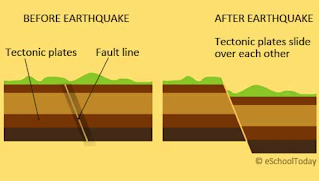
The uplifted Cadell fault forms a bifurcated scarp. A fault scarp is a small step or offset on the ground surface where one side of a fault has moved vertically with respect to the other. It is the topographic expression of faulting attributed to the displacement of the land surface by movement along faults. See the image above.
This northern part of the scarp extends for 55 kilometres from Deniliquin to Echuca with a height of 12–15 metres, and the southern part extends for 13 kilometres south of Echuca with a height of about 3–4 metres. The split between the two elements has been formed by the erosion caused by historic Lake Kanyapella. The fault deforms a 200- to 250-metre-thick section of sedimentary rock, which overlies a granitic base rock. To the west, the Cadell Tilt Block was formed subsequent to the uplift
Where you are now standing (just off the Cobb Highway) is part of the uplifted section of the fault. If you look across the paddocks you can see the Cadell Fault's impact on the landscape.
Logging the Cache
Your task is to answer a few simple questions:
1. Look east into the distance - can you see any elevation changes? How do you think this occurred?
2. Can you identify a scarp in the landscape before you? Where is it?
3. What is the height of the scarp at this particular location?
Once you complete the Earthcache requirements you can post your find without delay, as per the guidelines. You will also need to verify your find by sending me an email providing answers to the questions. This can be through the message centre or via gemmasiemensma@gmail.com
Thanks for visiting this Earthcache. I hope you enjoy it.
Sources:
https://en.wikipedia.org/wiki/Cadell_Fault
https://sites.google.com/site/tigerstalkingscience/earthquakes
https://en.wikipedia.org/wiki/Fault_scarp