This EarthCache was created under the guidelines of the Prescott Peavine National Recreation Trail administrated by the City of Prescott and is on public property. No physical cache or container has been placed for this or any EarthCache.
In order to log a find on this EarthCache read the cache page and send me the answers to the question below. This location is a several miles round trip hike or boat, much longer from Iron King trailhead. It is suitable and safe for children. The trail is well marked and an out and back from any either trailhead.
There are multiple ways to access this EarthCache, by foot, bike or boat. This is not a fee area depending on where you access the primary cache location. The parking area at Peavine Trailhead (waypoint 1) has a parking fee. If you chose to visit by boat (waypoint 3), Lake Watson does have an entry fee. The parking area at Iron King Trailhead (waypoint 2) does not have a parking fee. You can also park on the Peavine north trailhead (waypoint 5) does not have a parking fee. The trail is open to hiking, bicycling and equestrian use (no motorized vehicle traffic).
Please stay on the trail, rattle snakes frequent this area. The listed quadrantes can be accessed by land or water. If accessing in a boat, proper PFD’s are recommended and required for children. Make sure you account for any weather when venturing out on any body of water.
Objective
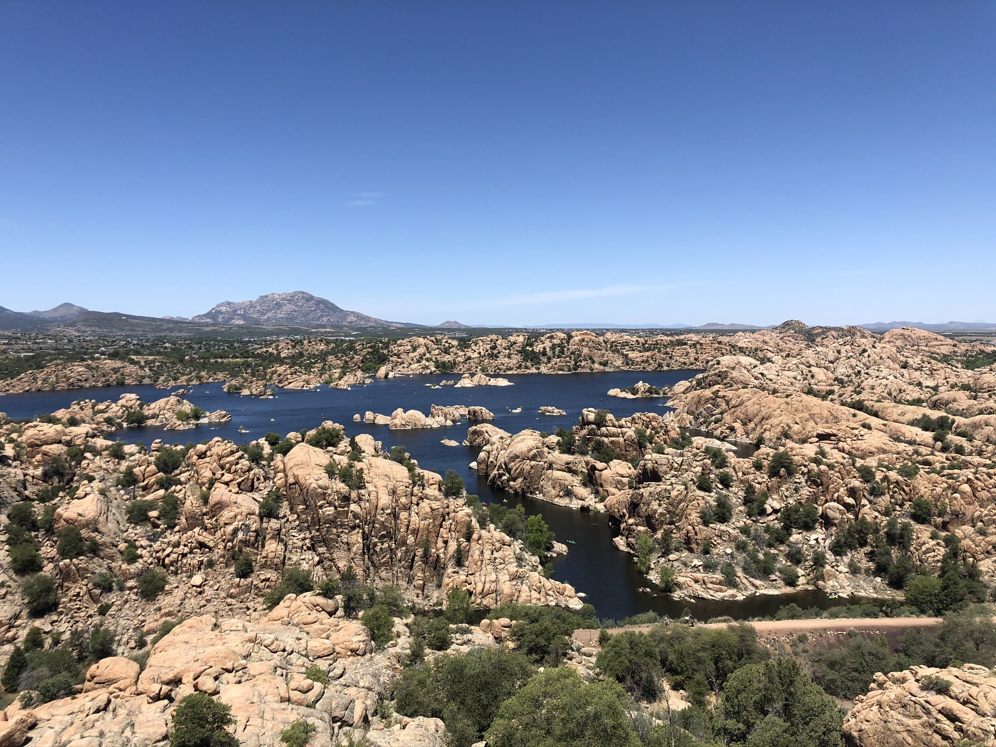
Understand the geology of this area with a focus on the formation of the Granite Dells.
Resources
The information included in this cache will give you a starting place to understand how the Granite Dells formed. There is also signage at waypoint 4 on the Peavine trail which will aid in your understanding. The Bibliography and Resource Links sections also have references and links for additional information that may aid in your visit.
Questions
In order to log this EarthCache, please complete the following and email your answer. Please include the cache name or cache number in the subject line. Also include any other cachers in your group that intend to log the find separately so their log isn't deleted.
- What key event in geology contributed to the formation of Granite Dells?
- How long ago was this plutonic structure formed?
- How big of a factor did erosion play in what we see today? Please explain.
Requirement: Please post a picture of yourself/group at GZ of the EC location. If camera shy, use a name badge of some sort to include in your photo posted on your log OR with your answers submitted to the cache owner (they will not be published, just used to verify a physical visit).
Geological Description
The Granite Dells is a Proterozoic formation and is about 1.4 billion years old. They were formed when molting magma intruded or pushed through the sedimentary rock above it but did not reach the surface. This is called basaltic or plutonic intrusion where magma, deep underground fractures the weaker structure above in vertical fissures but does not reach the surface. When magma freezes in these fissures it forms vertical curtain structures called a dyke. Without reaching the surface this dyke cools very slowly, sometimes hundreds or even thousands of years. During this slow cooling process, crystals have an opportunity to grown. Unlike magma that erupts on the surface (lava) and cools quickly this granite cooled slowly and have visible crystal structures. As the dykes cool, joints are created by the contraction of the granite.
With time the layers above the Granite Dells eroded away, exposing the hard granite dyke formation. It is estimated that the exposure of the Dells is much more recent, only several million years ago. The rounded appearance of individual boulder is the result of spheroidal weathering. This is a process whereby minerals contained in the granite, feldspars and micas, are chemically attacked along joints resulting in rounding the edges. The Dells are also radioactive due to the high concentration of uranium. This results in an anomalously high concentrations of radon. This has aided in the dating of this formation and its exposure at the surface.
Bibliography
Signage on the Peavine Trail at Waypoint 4
Prescott Arizona Mile-High Trail System, near Hwy 89 near Prescott AZ
Roadside Geology of Arizona by Halka Chronic
Twenty-eighth printing (2019) published by Mountain Press Publishing Co
Geology – A Complete Introduction by Dr David Rothery
5th Revision (2015) published by Hodder & Stoughton
University of Arizona / Arizona Geological Survey
link: https://azgs.arizona.edu/photo/granite-dells-prescott-arizona
USGS link: https://geonames.usgs.gov/apex/f?p=gnispq:3:0::NO::P3_FID:29476
Resource Links
https://www.exploreprescott.org/recreation-locations/the-granite-dells/
https://www.visitarizona.com/uniquely-az/parks-and-monuments/watson-lake-and-the-granite-dells
http://www.prescott-az.gov/recreation-area/prescott-peavine-national-recreation-trail-2/
https://www.mtbproject.com/trail/7001406/peavine-trail
https://www.mtbproject.com/trail/7001408/iron-king-trail
https://en.wikipedia.org/wiki/Granite_Dells