

Curonian Spit
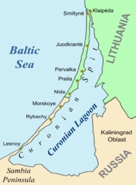
Curonian Spit is a narrow, long peninsula, in the form of a sandy shaft, in the south-east of the Baltic Sea coast. It is a secondary peninsula of the Sambian Peninsula. The spit separates the Curonian Lagoon from the open Baltic Sea. The length of the spit is 98 km, and its width varies from 400 to 3800 meters.
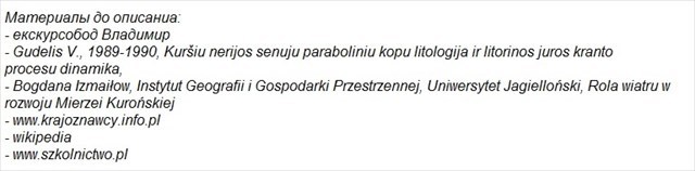
About 7,500 years ago, when the Baltic Sea development phase was called the Litor Sea, a large sea bay formed. 3,000 years later, from the western end of the bay began to form a spit. This was the beginning of the current Curonian Spit. With centuries, the spit has become increasingly lengthened, separating the waters of the bay from the sea. The waters of the bay merged with the existing coastal lake.
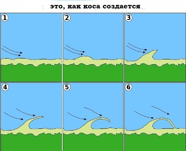
This is how the present Curonian Gulf was created. Initially, the spit was formed by litorprocesses, i.e. the transfer of sands and sediments taken from the mainland by sea currents. The material was carried by the existing coastal sea current occurring in the deep about 6-10 meters. Sands and gravel were washed away from ancient layers of the Samland Peninsula, as we know when comparing sediment compositions. On the sands of the spit we will meet glaukonite and phosphorus, which is found precisely in the former layers of The Samland South. In addition to litoral processes, eonic processes were involved in the process of building the spit, i.e. the action of wind on the sculpture of the site.
Soon it was the wind that had a major part in the further creation of the spit. Erosion [destruction of the coast] allowed water and wind to carry huge amounts of sand. There was a process of formation of dunes that formed a spit.
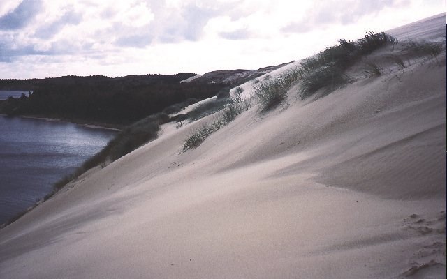
New, younger dunes were created, extending and expanding the strip of land. The process of creating and moving dunes lasted until the 14th century. Then there was the afforestation of the area. This resulted in a significant halt to the movement of sand and the process of stabilizing the dunes began. It didn't last long. Due to the development of settlement and the management of the spit, the felling of trees began, which reached large proportions in the 18th century. Vegetation only stood at about 10% of the spit area. This triggered strong aeolian processes - the wind carried huge amounts of sand. The old dunes have been almost completely dispelled.
New dunes were created. They were flooded man-made areas. The biggest severity of such a process was around 1860. The dunes moved 13 meters per year. The maximum migration was 320 meters. The wind, moving the sand, began to shape the shoreline of the Curonian Lagoon. Port entrances and entire settlements were filled; people had to leave their homes.
At the initiative of post office worker Georg David Kuwert and his father Gottlieb, special grasses and trees [mainly pines and birches] began to recreate the previous state. The activities lasted more than 100 years. At present 75% of the area is sylvan. This stopped the destructive effects of the wind. This does not mean that the sand is stationary. It is moved further. It is estimated that between 300,000 and 1,000 cubic meters of sand are carried per year.
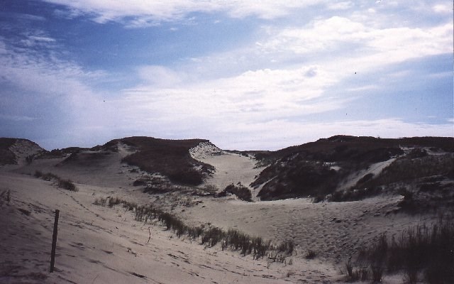
We can distinguish three zones:
erosion zone - wind and water take more sand than they carry. The beaches are underdeveloped and narrow. The sand is rough. The erosion zone extends throughout the Samland peninsula and the lower part of the Curonian Spit.
transit zone - the amount of sand picked up and taken away is approximately the same. The beaches are quite wide (from 35 to 75 meters), the sand has different granulations. This transit zone is located on the Curonian Spit between Rybatschi and Juodkrante.
deposit zone - in this zone the amount of brought sand is greater than taken. The beach is 75 to 100 meters wide. The sand has a small granulation. It occurs on the northern part of the spit, up to Klaipeda.
The Curonian Spit is the second largest formation of dunes in Europe. In 2000, it was a UNESCO World Heritage Site as a cultural object.
TASKS:
1. In the area of the spit, water and wind both supply and take sand. Look around you. Is the sand arriving, losing or whether the balance is maintained at this place? Justify your opinion.
2. The area behind the beach, inland is wooded. What trees are the most here?
3. Several villages on the Curonian Spit have been several times during the 17th and 18th centuries transferred to another location. Why?
4. Take a picture of yourself against the background of the beach - join the logo.
materials used:
- tour guide Wladimir,
- Gudelis V., 1989-1990, Kuršiu nerijos senuju paraboliniu kopu litologija ir litorinos juros kranto procesu dinamika,
- Bogdana Izmaiłow, Instytut Geografii i Gospodarki Przestrzennej, Uniwersytet Jagielloński, Rola wiatru w rozwoju Mierzei Kurońskiej
- www.krajoznawcy.info.pl
- wikipedia
- www.szkolnictwo.pl

Mierzeja Kurońska
Mierzeja Kurońska to wąski, długi półwysep, w postaci piaszczystego wału, w południowo-wschodniej części wybrzeża Morza Bałtyckiego. Jest ona półwyspem podrzędnym Półwyspu Sambijskiego. Mierzeja oddziela Zalew Kuroński od otwartego Morza Bałtyckiego.
Długość mierzei wynosi 98 km, a jej szerokość waha się od 400 do 3800 metrów.
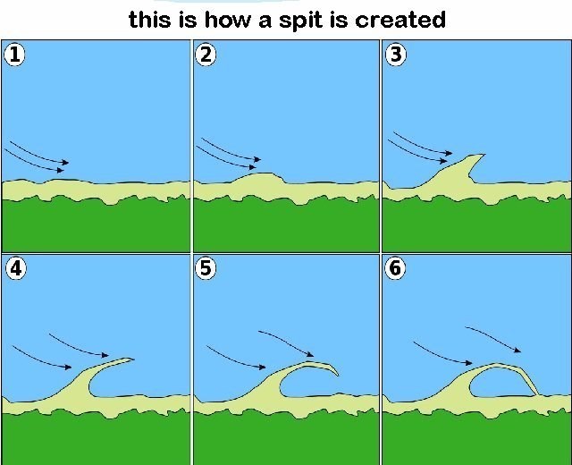
Około 7500 lat temu, gdy faza rozwoju Bałtyku była nazywana Morzem Litorynowym, utworzyła się spora zatoka morska. 3000 lat później od zachodniego krańca zatoki zaczęła się tworzyć mierzeja. Był to początek obecnej Mierzei Kurońskiej. Wraz z upływem stuleci mierzeja coraz bardziej się wydłużała, oddzielając wody zatoki od morza. Wody zatoki połączyły się z istniejącym przybrzeżnym jeziorem. W ten sposób powstała obecna Zatoka Kurońska.
Początkowo mierzeja tworzyła się na skutek procesów litoralnych, czyli przenoszenia piasków i osadów zabranych z lądu przez prądy morskie. Materiał był przenoszony przez istniejący tu przybrzeżny prąd morski występujący na głębokości około 6-10 metrów. Piaski i żwiry były wypłukiwane z pradawnych warstw Półwyspu Samland, o czym wiemy porównując składy osadów. Na piaskach mierzei spotkamy glaukonit i fosforyn, który występuje właśnie w dawnych warstwach Połwyspu Samland.
Oprócz procesów litoralnych w procesie budowy mierzei udział miały procesy eoliczne, czyli działanie wiatru na rzeźbę terenu. Wkrótce to właśnie wiatr miał główny udział w dalszym tworzeniu mierzei. Erozja [niszczenie terenu] wybrzeża pozwalała na przenoszenie przez wodę i wiatr ogromnych ilości piasku. Nastąpił proces tworzenia się wydm, które tworzyły mierzeję.
Powstawały coraz to nowe, młodsze wydmy, wydłużając i poszerzając pas lądu. Proces tworzenia i przesuwania się wydm trwał do XIV wieku. Wtedy nastąpiło zalesienie tego terenu. Spowodowało to znaczne zatrzymanie przemieszczania piasku i zaczął się proces stabilizacji wydm. Nie trwało to długo. W związku z rozwojem osadnictwa i zagospodarowywaniem mierzei zaczęła się wycinka drzew, która osiągnęła duże rozmiary w XVIII wieku. Roślinność postała tylko na około 10% obszaru mierzei. Uruchomiło to mocne procesy eoliczne - wiatr przenosił ogromne ilości piasku. Stare wydmy zostały prawie całkiem rozwiane.
Powstawały nowe wydmy. Zostały zasypywane zagospodarowane przez człowieka tereny. Największe nasilenie takiego procesu było około 1860 roku. Wydmy przesuwały się o 13 metrów na rok. Maksymalnie ich migracja wyniosła 320 metrów. Wiatr, przesuwając piasek, zaczął kształtować linię brzegową Zalewu kurońskiego. Zasypane zostały wejścia portowe i całe osady; ludzie musieli opuszczać swoje domostwa.
Z inicjatywy pracownika poczty Georga Davida Kuwerta oraz jego ojca Gottlieba, zaczęto sadzenie specjalnych traw i drzew [głównie sosen i brzóz], aby odtworzyć stan poprzedni. Działania trwały ponad 100 lat. Obecnie 75 % mierzei jest zalesiona. Powstrzymało to niszczycielskie działanie wiatru. Nie znaczy to, że piasek jest nieruchomy. Jest on dalej przemieszczany. Ocenia się, że na mierzei rocznie przenoszone jest od 300 000 do 1 000 000 metrów sześciennych piasku
Możemy wtróżnić trzy strefy:
strefa erozji - wiatr i woda zabierają więcej piasku niż nanoszą. Plaże są słabo rozwinięte i wąskie. Piasek jest szorstki. Strefa erozji rozciąga się na całym obszarze półwyspu Samland i dolnej części Mierzei Kurońskiej.
strefa tranzytowa - ilość piasku zabierana i nanoszona jest w przybliżeniu taka sama. Plaże są dosyć szerokie (od 35 do 75 metrów), piasek ma różne granulacje. Ta strefa tranzytowa znajduje się na Mierzei Kurońskiej między Rybatschi a Juodkrante.
strefa depozytowa - w tej strefie ilość piaku nanozona jest większa niż zabierana. Plaża ma od 75 do 100 metrów szerokości. Piesek ma małą granulację. Występuje na północnej części mierzei, aż do Kłajpedy.
Mierzeja Kurońska jest drugą co do wielkości formacją wydm w Europie. W roku 2000 została wpisana na listę światowego dziedzictwa UNESCO jako obiekt kultury.
ZADANIA
1. Na obszarze mierzei woda i wiatr zarówno dostarczają piasek jak i go zabierają. Rozejrzyj się wokół siebie. Czy w tym miejscu piasku przybywa, ubywa czy też zachowana jest równowaga ? Uzasadnij swoje zdanie.
2. Teren za plażą, w głąb lądu jest zalesiony. Jakich drzew jest tutaj najwięcej ?
3. Kilka wsi leżących na Mierzei Kurońskiej było na przestrzeni XVII i XVIII wieku kilkarotnie przenoszonych w inne miejsce. Dlaczego ?
4. Zrób sobie zdjęcie na tle plaży - dołącz do logu.
wykorzystano materiały:
- przewodnik Władimir,
- Gudelis V., 1989-1990, Kuršiu nerijos senuju paraboliniu kopu litologija ir litorinos juros kranto procesu dinamika,
- Bogdana Izmaiłow, Instytut Geografii i Gospodarki Przestrzennej, Uniwersytet Jagielloński, Rola wiatru w rozwoju Mierzei Kurońskiej
- www.krajoznawcy.info.pl
- wikipedia
- www.szkolnictwo.pl