This is an earthcache and as normal, there are a few questions to answer based on ground zero. If I don't get the answers to the questions within 24 hrs of your posted log, then the log will be deleted.
The Paskapoo slopes are a prominent landmark on the west side of the city of Calgary. The 4km long slopes are a natural feature composed of forested benches that were formed during the Pleistocene epoch by the action of water from Glacial Lake Calgary. The slopes are cut by a series of ravines and rise over 150m above the south side of the Trans Canada Highway. Development has slowly encroached the area since the 1990 but some of the area is protected as parkland by the City of Calgary.
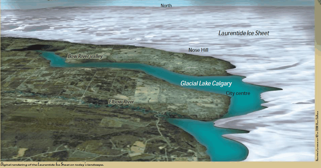
Digital rendering of the Laurentide Ice Sheet on today's landscape (Rectified Landsat on 60 m DEM: Ron DaRoza)
Geology of the area
The underlying rock is the hard sandstone of the Paskapoo Formation that were deposited 62.5 to 58.5 million years ago on a broad alluvial plane that extended east from the Rockies. There were several quarries for the sandstone that was used for building in the "sandstone era" (early 1900's). The Paskapoo slopes themselves are formed of glacial and preglacial sediments and colluvium accumulated along the northern slopes. Six benches were formed by the action of the waters in Glacial Lake Calgary and further eroded by springs and streams. The glacial ice 31-14 thousand years ago is believed to have been 1 km thick in this area. Glacial Lake Calgary was formed by meltwater that was backed up by the dam formed by the the Laurentide Ice sheet. The lake reached from the Paskapoo slopes across to Nose Hill.
The slopes are also home to one of the larger erratics within the city of Calgary and has been known by local inhabitants as the "Big Rock" (do you know it's famous cousin with the same name to the south?).
Calgary's Erratic Glacial History
Over the last 2 million years, a series of colder episodes caused most of Canada to be covered by thick glacier ice. We currently live in the latest of several warm interglacial periods that occurred between these glacial episodes. During the most recent glacial episode, which peaked about 20,000 years ago, a huge ice sheet from central and northern Canada (Laurentide Ice Sheet) met with Cordilleran glaciers flowing eastward out of valleys in the Rocky Mountains. They met along a line that passes through Calgary.

Ice sheets meeting in Calgary
Glacial Lake Calgary
About 17 thousand years ago, mountain ice that filled the Bow River valley began to melt and the eastern margin declined westward. Meltwater from the glacier were trapped by the Laurentide Ice Sheet in the center of Calgary, where they formed Glacial Lake Calgary. Fine sediments that were deposited in the lake are now the soil of much of the western part of Calgary. Mountain ice remnants remain today in the form of glaciers on the highest peaks of the Rocky Mountains.
Earthcache location access
GZ can be accessed by trails from near Winsport, from below in the new developing area of Trinity Hills or from above in Cougar Ridge. Note that some of the trails are quite steep. The Paskapoo slopes are home to an extensive network of mountain bike trails. Those on foot should be aware of the bike traffic. I would recommend sticking to the wider trails and/or be ready to jump out of the way! The erratic also seems to be a popular spot for kids to play and picnics.
SOURCE : https://www.cgenarchive.org/calgary-glaciers.html
Please message me the answers to the following questions based on observations on Paskapoo's slopes:
1. Estimate the distance from the cache site to Nose Hill (the width of the Glacial Lake).
2. Estimate the height above the Bow river from this location (depth).
3. How many people are sitting on the erratic in the picture from the 1950's and what's their family name?
4. Estimate the slope angle on the erratic S facing side, and tell me how you determined that.
5. Post a picture of your group (simulate one to the pictures on the sign if possible) or you and your GPS at the earthcache site.
If I don't get the answers to the questions within 24 hrs of your posted log, then the log will be deleted.