Valleys
A valley is a low area of land between hills or mountains, typically with a river or stream flowing through it. Valleys are one of the most common landforms on the surface of the planet. There are three main types of valleys, the V-shaped valley, the flat floored valley and the U-shaped valley.
V Shaped
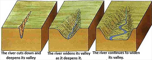
Valleys V shaped valleys are valleys formed by rivers, they have a V-shaped cross-section and very steep sides. These valleys are usually found near the source of a river due to the presence of a steeper bank, however, they can also be formed downstream. V-shaped valleys are formed by erosion. The river carries stones and rocks in its water. The force of the water and the grinding of rocks and stones cut down into the river bed to carve out a valley. Over time the valley becomes deeper and wider.
U-Shaped Valleys
A U-shaped valley is the shape left after a valley has been deepened by a glacier. The original V-shaped valley, which would have been made by a river, is widened and deepened after the ice has eroded the sides and bottom of the valley.
Flat Floored Valleys
The third type of valley is called a flat-floored valley and is the most common type in the world. These valleys, like V-shaped valleys, are formed by streams, but they are usually older, or more developed. As the slope of a stream's channel becomes smooth, and begins to smooth the steep V or U-shaped valley, the valley floor gets wider.
Over time, the stream continues to erode the valley's soil, widening it further. During this process, the shape of the valley changes from a V or U shaped valley into one with a broad flat valley floor. An example of a flat-floored valley is the Nile River Valley.
 Valley Formation
Welcome to Dog Pound Kountry!
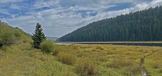 Winchell Lake Valley
As you walk along the shores of the mighty Winchell Lake, take a minute to observe the walls of the valley, the valley floor and the size of the creeks that feed the lake.
To get the best experience from this earth cache, take a stroll for about 1000m to the west along the the old two track path. (You will be able to cache along the way.) Take note of the elevation at both ends of the lake.
Isn't mother nature grand!!!!
To log this Earth Cache, send your answers to the following questions to the CO.
1.) What type of valley system is the Winchell Lake Valley?
2.) How wide are the creeks that feed the lake? Compare this to the width of the valley floor.
3.) Describe the shape of the valley floor? Is this a younger or older valley? Explain.
4.) How much elevation change do you measure from ground zero to the west end of the lake? Comment on your observation.
5.) At Ground Zero there are two signs. How many mammals are on "The Wildlife of Winchell Lake"?
6.) Optional: Post a photo of you and your group along the lake shore.