This is a two part earthcache along Cañada Road. You will need to visit both sites to answer all the questions and to log this as a find. The above coordinates are for the bottom of the unit and the site two coordinates are for the top of the unit, assuming superposition and continuous beds. I'll get into more details on what these mean later on, but for now keep these terms in mind when visited this unque site.
I saw these outcrops while driving by to get a nearby multi cache and I thought this would be a great place for a geology lesson, and an earthcache. So I did some research and here is what I found. The above coordinates will bring you to the lower part of the outcrop. By this I mean they are the oldest part. The Law of Superposition is well known in geology and it states that the oldest layers are on the bottom, and younger ones are found on the top. This makes sence as there had to have been units below in order for the units above to form. This law can be broken if certian conditons are not met.

1, the layers pinch out. This means that the layers get thinner and thinner with distance. In order for the law of superposition to hold up, layers must have the same thickness. Looking at a small scale such as these two sites, the thickness of layers can be assumed to be the same.
2, the layers are folded or tilted. Folding occurs when there is regionalized or localized stress that can crunch the layers into wave like patterns. This can distort our interpretation of the law of superposition in which the oldest layers could be found at the top rather than at the bottom of units. Tilting can also occur where the layers are at some angle to the horizontail. However, if the angle is 180 degrees then the oldest layers would actually be found at the top rather than the bottom. This is uncommon in the feild, but is something to keep in mind.
3, the layers are faulted. Faults can offset units and bring older units to the surface along side younger ones. This occurs most frequently with normal faults, which is a type of thrust fault. However this can also occur with reverse thrust faults as well.
The formation visable at site 1 (at the above coordinates) is called the Monterey Formation, which can be found all accross the coastal regions of California. The Monterey Formation is Miocene in age meaning it is between 17 and 5 million years old. It consits of sandstone, shales, and siltstones. It formed in a shallow marine environment when this area was underwater. Looking closely, you can see sandstone interbedded with silstone layers. The sandstone is the dark brown on a uncut surfaces, and whiteish tan on a freashly cut surface. The siltstone looks more blocky and crumbles easier and is much thiner, normally, than the sandstone beds.
The formation visable at site 2 (see wayppoints for coordinates) is an Quaternary alluvium deposit, meaning it formed in the last 2.5 million years. It makes sence that going up section, the younger Quaternary aged alluvium unit is found above the older Miocene aged, Monterey Formation. Here, the outcrop appears to be much more consolidated, but less cemented (compacted) as rivers are limited in both size, flow, and materail. There are two main observations that made me belive site 2 was formed by alluvium processes. One, thier appears to be one large bed unlike site 1 where multiple beds are present. And two, the presence of rounded clasts a few inches accress which can only be formed by constant flowing water. If you would look up close at the unit, it is likley made of sandstone that is poorly cemented. Cementation is what holds grains together to form a rock. Common types of cementation are quartz, calcium carbonate (in the case of limestone), iron oxides, and clay minerals such as smectite, illite, cholrite, and kaolinte. It appears here very little time has passed for any substantion cementation to occur becuse of the errosional features are more distinctive here than site 1. Be sure to pay close attention to the sand sized sediment building up on outcrop. Notice how this is not occuring at the same rate as site 1.
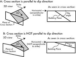
A common practice for geologists in the feild is to take strike and dip mesurments of an outcrop. Dip is easier to explain so let me first describe it. Dip is the angle in which the bed is orientated with respect to the horizontal. For example, the horizontal is an imaginary line that marks the horizon. A bed that has a dip of 0 degree appears flat when viewed in the feild. Likewise, a bed that dips 90 degress appears as if it is going stright into the ground. Take a tree for an example. A tree would have a dip of 90 degrees. If the tree fell and is now flat in a forest, then the dip of that tree would be 0 degrees. Dip is always perpendicular (90 degrees) to the strike direction.
The strike is the azumith notation (from 000 [being from true north] to 360) of the bed contact when it is horizontal. The bed contact is an imaginary line that seperates one bed type to another. At site 1, there are many bed contacts, however none of them are horizontal so you will need to make educated inferences into what the strike is using information in this cache page. So for example, if the horizontal contact line between the bed is facing due north the strike could be one of two options. It could be a north striking bed (written as 000) or it could be a south striking bed (written as 180). Either one would be correct, but which one is the right one? Well, you can use something called the right hand rule.
The right hand rule (RHR) helps geologist determine the correct strike and dip measurments. Refer to the image below. First, use your right hand. Keep your palm flat for now. Make a right angle between your fingers and your thumb. Your fingers represent the dip direction. In other words, the direction in which the bed is dipping (not the actual angle of the dip). At site 1, this is to the left for comparison. Your thumb represent the strike direction. In other words, the azimuth direction. So to determine if the bed is striking 000 or 180, you will need to know which way the bed is dipping.

One thing you should keep in mind is that the dip you are seeing may not be the true dip. If you are looking at some angle to the outcrop, the dip may be less than what it actually is. This is called the apparent dip and can be confusing to comprehend, especally when in the feild. For example if the true dip of a bed is 50 degrees, and the outcrop is at some angle that is not 90 degrees to that dip direction, the dip angle will be some angle less than 50 degrees. This is why the strike and dip are perpendicular to each other. If you are not perpendicular, then the measurments will be based off the apparent dip and your stike measurments would be incorrect. You cannot tell by looking at one site if what you are looking at is indeed the true dip or not. However, for the purposes of this earthcache assume that what you are looking at is the true dip of the bed. This is something you should always think about when taking strike and dip measurments. It's not always what it seems to be.
Geologist use numerous ways to write strike and dip measuremnts. Me, personally, I like the azimuth notation followed by the dip angle. The dip direction can be infered using right hand rule, so it is omitted. The convention is that the strike is written first, followed by the dip. Also, using azimuth notation, the strike direction is read using 3 digits for clarity. For example, my strike and dip measurments would be read as:
010, 45
185, 15
032, 71
Some other methods include using compass directions. For example you would use a reference diection. Most commonly from north (N) and south (S) followed by the compas declination, then followed by another direction either west (W) or east (E). Like azimuth, the convention is that strike is written before the dip. Also unlike azimuth, the strike is written as one or two digits from 0 to 90. The following strike and dip measurments are equal to the ones above and would read as:
N10E 45
S5W 15
N32E 71
The way you would read is "Strike direction is: from North, go 10 degrees towards the east". Notice how the comma is omitted using this compass notation and is included using azimuth notation.
TO LOG A FIND ON THIS CACHE YOU MUST ANSWER ALL THE QUESTIONS BELOW. YOU CAN CONTACT ME THROUGH MY EMAIL OR THE GEOCACHING MESSAGE CENTER TO SEND YOUR ANSWERS. ANY INCORRECT ANSWERS MAY RESULT IN A CLARIFICATION RESPONSE FROM ME.
1. "Cañada Road Geology" on the first line of your email AND list all geocaching names of your party so I can match your answers to them. If you all want to learn something, I would prefer each cacher send me individual emails in the spirt of earthcaching.
Site 1 Questions
2. Estimate the strike and dip of the beds. Assume that what you are looking at is the true dip. If so, the strike of the bed is not visable from the outcrop so you will need to use the right hand rule to determine it. You may want to do multiples calulations and take the average to get a good estimate. This can be completed safely from the sidewalk.
3. How thick are the sandstone beds? How thin are the siltstone beds? Which one weathers more easily? HINT: Think about which layer protudes outward being the most resilient to weathering.
4. What type of cementation is holding the grains together? Note how it is well cemented due to little weathering.
Site 2 Questions
5. Describe the alluvium cobbles. How large are they, colors, roundenss, ect. Do you think they were sourced locally or traveled far before being incorperated in this outcrop? Explain.
6. This outcroop appears to be less held together than site 1. What type of cementation is occuring here to make it less resistant to weathering? HINT: Look on the left side of the outcrop, roughly eye level. Very easy to miss, but an important aspect to understand. Refer back to the cache descitption if needed.
Questions While Visiting Both Sites
7. Based on your observations, do these two sites appear to follow the Law of Superpostion? If not, what do you see that contraditcts this law (see the cache description on examples)? If so, explain why.
8. Take a photo of you (or your GPS if you don't want to show your face) with the background of the image looking either upsection or down section. This can be best completed by standing on the sidewalk at either of the site coordinates. Explain if the camera view is showing up section or down section and weather you are standing at Site 1 or Site 2.
Works Cited
https://nwgeology.wordpress.com/geology-basics/sedimentary-rock-structure-strike-and-dip/
https://maps.conservation.ca.gov/cgs/gmc/
https://websites.pmc.ucsc.edu/~crowe/ES109/labs/strike-dip-handout.pdf
https://geologydegree.org/superposition-geology/