Cape Byron forms the most easterly point of mainland Australia. The area upon which you are standing is 94m above sea level and was formed from volcanic rock that has cooled and been eroded by the waves and weather over millions of years to form the cape.
How did this happen?
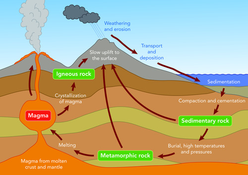
Cape Byron is part of the wider area sedimentary basin known as the Clarence-Morten basin. Sedimentary rocks were laid down in this basin approximately 135 to 200 million years ago. These rocks were formed as sediment collected in the basin and over the course of millenia became flattened and compressed as new layers of sediment were formed over the existing layers. Over time this collection of sediment became buried under the earth as more and more new layers formed above. Due to the enourmous pressure and weight from above, these sediments were compressed together and become sedimentary rock. This process is known as sedimentation.
A shield type volcano known as the Tweed Volcano eventually formed over the basin as a result of techtonic plate movement from the Indo-Australian techtonic plate moving over the east Australian volcanic hotspot. The resulting build up of pressure from these techtonic plate movements caused the Tweed Volcano to erupt 23 million years ago. This eruption resulted in the buried sedimentary rock being bought up to the surface with the resulting magma from the earths crust. On it's way upto the surface, the magma criystalizes while mixing with the sedimentary rock. Once the molten mixture of magma and sedimentary rock (knowen as metamorphic rock) reaches the surface, it cools to form Igneous volcanic rock.
Over time, this igenous rock is exposed to the weather and tides which results in erosion. This erosion creates more sediment and the cycle is repeated.
In order to log your visit, you will need to consider your surroundings and answer the following questions:
1. From where you are standing, look directly east and you will see waves crashing on the rocks just in front of you. What kind of rocks are these? (Multiple choice question: Answer either A, B or C)
A. Igneous
B. Metamorphic
C: Sedimentary
2. Now turn around so you are facing west and stand on one foot. look at the bottom of your foot, plugger or shoe (or if you are unable to look at the bottom of your foot, just look at the ground around your feet) You will notice bits of loose dirt and grit. What is the name of the process from which this dirt is loosened from the volcanic rocks that you were just looking at to make sediment?
Do not include your answers with your log, send them to me as a pm.
To prove that you were here, please also leave a photo in the log of yourself with the Byron Bay lighthouse in the background of the photo.