Questions pour valider cette earthcache :
D'après vos observations et à l'aide du descriptif :
Questions to validate this earthcache :
Based on your observations and using the description :
Question 0
Joindre à votre log (PAS A VOS REPONSES) une photo de vous ou une partie de vous AVEC votre GPS, votre GC perso ou tout autre objet de geocaching aux coordonnées de la cache (SANS MONTRER LA VITRINE OU LE PANNEAU).
Les simples photos de paysage ou capture d'écran de votre position ne permettent pas de valider cette condition de log.
Cette tâche est obligatoire et autorisée par les guidelines mises à jour en juin 2019.
Les logs ne répondant pas à cette condition seront supprimés sans préavis
Attach to your log (NOT TO YOUR ANSWERS) a photo of you or a part of yourself WITH your GPS, your personal GC or any other geocaching object at the posted coordinates (WITHOUT SHOWING THE ANSWERS !).
The simple photos of the landscape or screenshot of your position do not validate this log condition.
This task is mandatory and allowed by the guidelines updated in june 2019.
Logs not meeting this condition will be deleted without notice.
Question 1
Dessinez un croquis faisant apparaître les différentes couches que vous pouvez observer dans la vitrine. (disposition, couleur, fossiles)
Photographiez ou scannez votre croquis pour me le faire parvenir. Attention, le croquis doit être réalisé de votre main.
Chaque joueur souhaitant loguer cette Earthcache doit envoyer son propre croquis.
!! 1 PSEUDO = 1 CROQUIS !!
Draw a sketch showing the different layers that you can observe in the showcase. (arrangement, color, fossils)
Photograph or scan your sketch to send it to me. Please note, the sketch must be done by hand.
Each player wishing to log this Earthcache must send their own sketch.
!! 1 PSEUDO = 1 SKETCH !!
Question 2
D'après vous, quel est le type de lacune observable ici ? Expliquez votre raisonnement.
What type of gap do you think can be observed here ? Explain your reasoning.
Question 3
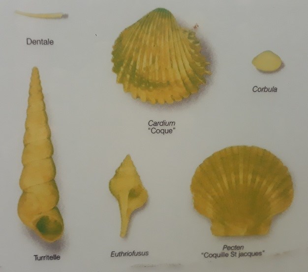
Dans quelle couche trouve-t-on le plus de fossiles ?
In which layer are the most fossils found ?
Question 4
Identifiez le type de fossile le plus abondant.
Identify the most abundant type of fossil.
Envoyez-moi vos propositions de réponses soit via mon profil, soit via la messagerie geocaching.com (Message Center) PUIS loguez cette cache "Found it", je vous contacterai en cas de problème.
Assurez vous de répondre à TOUTES les questions ! La condition principale pour loguer une Earthcache étant de répondre aux questions posées dans le descriptif, tout log "Found it" enregistré sans envoi préalable de vos propositions de réponses sera supprimé. Il en sera de même pour les logs enregistrés sans la photo requise.
Send me your proposals for answers either via my profile or via the geocaching.com messaging (Message Center) THEN log this cache "Found it", I will contact you in case of problem.
Make sure to answer ALL questions ! The main condition to log an Earthcache is to answer the questions asked in the description, any log "Found it" registered without prior submission of your proposals of answers will be deleted. It will be the same for logs saved without the required photo.

La Réserve Naturelle géologique de Saucats - La Brède est la première RNG de France (1982), elle est née sous l'impulsion d'universitaires, d'enseignants du secondaire et d'élus qui voyaient disparaître un à un les sites géologiques du Bordelais en raison de l'urbanisation. De plus, l'accroissement de la "collectionnite" mettait parfois en danger l'avenir des sites historiques saucatais, mondialement connus comme références (stratotypes) pour les temps géologiques.
Les niveaux géologiques protégés par la RNG se situent dans 3 étages de l’ére tertiaire (époque miocène) : successivement Aquitanien (23 à 20,5 Ma), Burdigalien (20,5 à 16,4 Ma), Serravallien (14,8 à 11,2 Ma).
The Saucats - La Brède geological nature reserve is the the first GNR in France (1982), it was created under the impetus of academics, secondary school teachers and elected officials who saw the geological sites of Bordeaux disappear one by one due to urbanization. In addition, the increase in "collection" sometimes endangered the future of historic sites in Saucat, known worldwide as references (stratotypes) for geological time.
The geological levels protected by the GNR are located in 3 stages of the Tertiary era (Miocene era): successively Aquitanian (23 to 20.5 Ma), Burdigalien (20.5 to 16.4 Ma), Serravallien (14.8 at 11.2 Ma).
Site de la Bourasse
Les roches sédimentaires sont disposées en couches. Elles appartiennent à une fraction de l'ère tertiaire : l'Aquitanien et le Burdigalien. Elles sont surmontées de dépôts continentaux du Quaternaire.
Les temps géologiques sont caractérisés par des phases d'avancée (transgression) et de recul (regression) de la mer. Ces phénomènes s'expliquent par des variations du niveau global de la mer ou par des mouvements du bassin sédimentaire.
Chaque couche, par la nature du sédiment (argile, calcaire, sable, falun, ...) et les fossiles qu'elle renferme caractérise un milieu. On voit ici la superposition de calcaires continentaux aquitaniens et d'un niveau burdigalien.
Ces niveaux sont séparés par une lacune d'environ 1 million d'année.
Lacune :
Lorsqu'il n'y a pas de continuité chronologique entre deux couches, on parle de lacune. Il y a deux types de lacunes :
- Lacune d'érosion : l'érosion a enlevé des couches, puis la sédimentation a repris en laissant subsister la lacune.
- Lacune de sédimentation : pendant la période correspondant à la durée de la lacune, la sédimentation s'est interrompue. Celle-ci est généralement due à une régression marine.
La Bourasse site
Sedimentary rocks are arranged in layers. They belong to a fraction of the Tertiary era: the Aquitanian and the Burdigalian. They are surmounted by continental Quaternary deposits.
Geological times are characterized by phases of advancing (transgression) and retreating (regression) of the sea. These phenomena are explained by variations in the global sea level or by movements of the sedimentary basin.
Each layer, by the nature of the sediment (clay, limestone, sand, falun, ...) and the fossils it contains characterizes an environment. We see here the superposition of continental aquitanian limestones and a Burdigalian level.
These levels are separated by a gap of about 1 million years.
Gap:
When there is no chronological continuity between two layers, we speak of a gap. There are two types of gaps:
- Erosion gap: erosion removed layers, then sedimentation resumed leaving the gap.
- Sedimentation gap: during the period corresponding to the duration of the gap, sedimentation was interrupted. This is generally due to a marine regression.