이곳에서는 2011년 7월말 3일간 지속된 약 500mm의 국지성 폭우로 인해 수많은 인명피해 및 재산 피해를 발생시킨 산사태가 발생하였습니다. 이곳에서 우리는 산사태의 원인과 유형에 대해 알아보고, 산사태를 예방하는 시설에는 어떤 것이 있는지 살펴보겠습니다.
산사태는 "질량소비(Mass Wasting)"라고 불리는 지질학적 과정의 일부로서, 중력의 힘에 의해 물질의 하강 움직임이 나타나는 것이 특징이다. 산사태를 촉발하는 조건은 다음과 같다.
- 토양 및 암석재료의 수분 포화
- 지진이나 폭발로 인한 진동
- 침식 또는 굴착에 의해 경사면이 가파르게 변화
- 경사면 상부에 재료(충전 등)를 추가하여 경사면이 가파르게 변화
- 동결융해의 반복
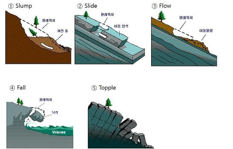
산사태의 유형은 형태, 외형 등에 의하여 지반꺼짐, 토석 미끄러짐, 토석 흐름, 낙하, 급류, 넘어짐 등이 있습니다.
- 먼저 지반 꺼짐(slump)은 하부침식이나 호우로 인해 흙이 움푹 꺼지는 현상입니다. 작게는 우리 주변에서도 흔히 볼 수 있고, 언덕배기가 내려앉는 대규모의 현상도 발생합니다.
- 토석 미끄러짐(slide) 는 포화되지 않았거나 압밀되지 않은 물질 혹은 암석이 오랜 기간 동안 풍화작용을 받아 급속도로 연약면과 평행한 방향으로 미끄러지면서 흘러내리는 현상입니다. 이때 이동 물질은 움직이는 동안 심하게 손상되거나 조각 조각 부서집니다. 이런 파편들로 인해 추가적인 피해가 발생하는 것이 특징입니다. 주로 급경사 지형에서 발생하나 15도 내외의 경사에서 발생하기도 합니다.
- 토석 흐름(flow)는 점성이 높은 포화된 물질이 흘러내리는 현상으로 일반적으로 지반 꺼짐 보다 빠른 속도로 발생합니다. 진흙처럼 점성이 크기 때문에 돌덩어리나 나무 혹은 자동차를 움직일 정도입니다.
- 낙하(fall)은 압밀되지 않은 덩어리 형태의 물질 혹은 암석이 사면으로부터 떨어져 튀거나 구르면서 자유 낙하하는 현상입니다. 이탈리아에서 발생했던 Vaiont 댐 붕괴사건의 원인으로서 이 사건은 댐 주변의 계곡에서 수만 톤의 암석이 댐으로 떨어져 수위가 대략 100m나 상승하여 약 8000 명의 사상자를 냈습니다.
- 넘어짐(topple)은 경사면의 끝에서부터 암석이 부서져 내리는 현상으로서 흔히 전도파괴라고 합니다. 다른 것들이 미끄러지거나 흘러내리는 것에 비하여 이 현상은 암석이 넘어지는 것이 특징입니다.
There was a landslide here that caused numerous personal and property damages due to the local heavy rain of about 500mm that lasted for 3 days at the end of July 2011. Here, we'll study on the causes and types of landslides, and see what facilities prevent landslides.
Landslides are part of a geologic process called "mass wasting," which is characterized by the downslope movement of material under the force of gravity. Conditions that precipitate landslides include:
- Saturation of soil and rock material with water
- Vibrations due to earthquakes or blasting
- Oversteepening of slopes by undercutting (removal of material through erosion or excavation)
- Oversteepening of slopes by addition of material (such as fill) on the upper portions of the slopes
- Alternating freezing and thawing
Types of landslides include ground breaking, soil sliding, soil flow, falling, rapid currents, and falling due to shape, appearance, etc.
- Slump - a landslide consisting of a mass of material moving downslope as a unit, usually along a curved plane of failure. The removed mass of soil and rock leave an abrupt drop-off at the top of the landslide known as a scarp. Repeated slumping can often result in terracing, or a series of scarps, as secondary failures occur within the landslide mass.
- Slide - the rapid movement of a large mass of rock along a plane of weakness, such as a bedding plane or joint. In general, rock slides occur on steep mountain faces but have been known to occur on slopes as low as 15 degrees.
- Flows - a mixture of rock fragments, soil, vegetation, water and, in some cases, entrained air that flows downhill as a fluid. Debris flows can range in consistency from that of freshly mixed concrete to running water. Debris flows can be further classified as mudflows and earthflows depending on the ratio of water to soil and rock debris. Lahars are a special form of debris flow caused by volcanic eruptions.
- Fall - the freefall of rock from a cliff. Rock falls are often the result of physical weathering such as ice wedging. The rock typically accumulates at the base of the cliff in the form of talus (loose rock). Rock falls are often triggered by earthquakes.
- Topple - the forward rotation out of the slope of a mass of soil or rock about a point or axis below the centre of gravity of the displaced mass. Toppling is sometimes driven by gravity exerted by material upslope of the displaced mass and sometimes by water or ice in cracks in the mass
[로그하는 방법]
- Waypoint 1에서 그곳의 지질을 살펴보고 다음 물음에 답하세요. (1) 이곳의 지질의 특성에 대해 설명하세요. (2) (1)을 근거로 이곳에서 발생한 산사태의 원인과 유형은 무엇이라고 생각하나요?
- 캐시존에서 관찰되는 산사태 예방시설들에는 어떤 것들이 있는지 두가지 이상 나열하세요.
- 캐시존에서는 두개의 골짜기를 볼 수 있습니다. 2011년 당시 산사태에서 두개의 골짜기와 그 사이의 모든 것들이 쓸려 내려갔는데, 그 전체의 폭은 대략 얼마인가요?
- Waypoint 2에 있는 산사태 예방 공사와 관련된 정보가 쓰여진 검은색 돌판을 배경으로 찍은 당신 또는 당신의 GPS 사진을 로그에 올려주세요!
- 답을 제 Profile에 있는 메시지창을 이용해 제게 보내주세요. 이제 로그하셔도 됩니다. 답에 문제가 있을 경우 제가 메시지를 드리겠습니다
[How to log]
- Take a look at the geology at Waypoint 1 and answer the following questions. (1) Explain the characteristics of the geology here. (2) Based on (1), what, do you think, are the cause(s) and type of landslide that occurred here?
- List at least two of the landslide prevention facilities observed in the cache zone.
- Two valleys can be seen in the cash zone. In 2011, a landslide swept away the two valleys and everything in between. What is the width of the whole?
- Please upload your or your GPS photo against the background of a black stone plate with information about landslide prevention work at Waypoint 2!
- Please send the answers to me by message on my profile! You may log as 'Found'. If the answer is not correct, I will contact you.
(REF)
Ministry of Education, Korea
Association of Environmental Engineering & Geologists
| I have earned GSA's highest level: |
 |
Congrats to jiho kim for FTF!