Welcome to Blackspring Ridge, the largest (as of 2020) wind power project in Alberta. This field generates 1,000GWh per year which is enough to power 119,000 Albertan homes! The happy accident of this construction was that dinosaur fossils was found during the construction!
At this site you will find some interpretive signage about the construction of the wind farm and the fossils they found in the process. This is where you will find your answers. There is also a real blade from an actual wind turbine nearby!
How Did These Fossils Get Here?
Alberta and Saskatchewan were not always the vast prairies and boreal forests you see today. Between continental drift, sea level change, and continental uplifting, North America has been bifurcated several times by a shallow sea.
On the Pacific Coast where the Pacific Plate subducts under the North American plate, the tremendous geologic forces cause uplifting and create numerous bands of north-south mountain ranges on the west side of North America. To the east of the mountains however, these forces have the opposite effect and in fact press the land downwards, creating a depression in the middle of North America. The downward deflection is exacerbated by the Canadian Shield, an ancient and unyielding Granite mass the size of Ontario and Quebec, which results in Alberta and Saskatchewan being squeezed.
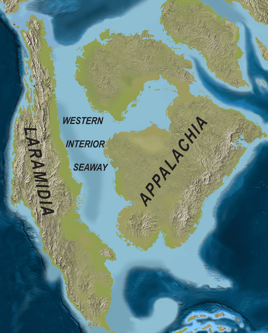
This downward bending, accompanied by warm periods where glaciers melted, resulted in the gradual flooding of this massive valley and made Alaska, BC, Washington, Oregon, California, and Mexico an island. The water bifurcating the two landmasses (Laramidia and Appalacia) was called the Western Interior Seaway.
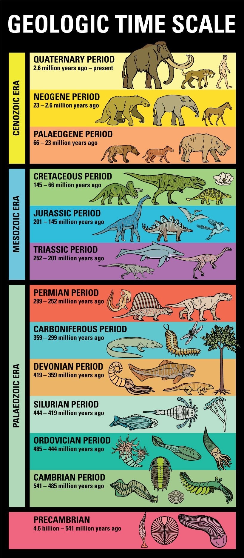
Over time there have been many seas, taking as much as 50 million years to flood and ebb:
- Cambrian Sea - Age of Trilobites, jellyfishes, sponges, and worms
- Ordovician Sea - Existed for 25 - 50 million years
- Silurian Sea - Just a blip in time and a very thin rock layer was deposited
- Devonian Sea - Age of corals and fishes where much of the oil and gas wealth was created such as in Leduc, Redwater, and Norman Wells
- Cretacious Sea - Creator of Rocky Mountain coal and the Athabasca Oil Sands
This sea was never very deep (around 600 feet) and much of the time the lower depths were anoxic (lacking oxygen) and the bottom of the sea quite muddy. This made for the perfect conditions for recently deceased plants and animals to be buried in silt and not rot away, and instead be converted into fossils. This shallow water made for excellent conditions for coral reefs to grow and their porous (spongy) nature has made for some of the most well-known oil deposits in western Canada including Norman Wells, Leduc, Woodbend and Redwater.
Since sunlight could penetrate much of the total depths of the sea, the water teemed with giant sharks, turtles, and fish; some of the biggest animals in their respective families to ever exist!
In the early Jurassic Period, the Rocky Mountains did not yet exist, and the land started to gradually rise from the Pacific Ocean as the Black Hills in South Dakota gradually lifted the land. The deltas turned into swamps, and the swamps eventually in dry land where the dinosaurs thrived throughout the Jurassic and Cretaceous periods. Near the end of the Cretaceous Period the glaciers started to melt and the sea rose submerging Alberta for the final time in a shallow sea.
Many swampy plains of the world had dinosaurs during the Cretaceous age, but the evidence of the fossils strongly suggests that nowhere were conditions more suitable nor the animals more abundant than in Alberta. One twenty-five-mile stretch of the Red Deer River valley near Brooks has alone produced remains of more than a hundred dinosaurs, thirty-six of them complete or almost-complete skeletons. One square mile near Sand Creek has provided museums with thirteen dinosaur skeletons or partial skeletons. Dinosaur fossils have also been found along the Milk River in southern Alberta and in the Cypress Hills region of southwestern Saskatchewan.
Questions
Please submit your answers to me through Geocaching message centre at the time of logging in order to verify your visit. Logs lacking accompanying answers within a week of a logged visit will be deleted.
1.) What are the 6 types of remains found at the base of the turbine?
2.) How many sites required palaeontological construction monitoring under the Historical Resources Act?
3.) How many sites were fossiliferous to record as a site?
4.) Which dinosaur did the tibia come from?
References
Bodsworth, Fred. “How the Prairies Were Made.” Maclean's | The Complete Archive, Maclean's, 25 June 1955, archive.macleans.ca/article/1955/6/25/how-the-prairies-were-made.
“Cretaceous Atlas of Ancient Life: Geology.” Cretaceous Atlas of Ancient Life | Geology, Cretaceous Atlas of Ancient Life, www.cretaceousatlas.org/geology/.
Duggan, Graham. “100 Million Years Ago, Alberta Was a Giant Sea, Surrounded by Tropical Forests.” CBC News , CBC/Radio Canada, www.cbc.ca/natureofthings/features/100-million-years-ago-alberta-was-a-giant-sea-surrounded-by-tropical-forest.
Panciroli, Elsa. “A Glimpse of When Canada's Badlands Were a Lush Dinosaur Forest by the Sea.” The Guardian, Guardian News and Media, 27 Sept. 2017, www.theguardian.com/science/2017/sep/27/a-glimpse-of-when-canadas-badlands-were-a-lush-dinosaur-forest-by-the-sea.
Us, Kimberly. “Interstate-10 Dinosaurs Named Dinny and Mr. Rex.” Medium, Kimberly Us, 8 Aug. 2020, kimberlyus.medium.com/interstate-10-dinosaurs-named-dinny-and-mr-rex-21b791552f.