Atikokan, in the Rainy River District of Northern Ontario has a rich mining history that the town has proudly put on display for local visitors. The name Atikokan is believed to be derived from the Aboriginal language Ojibwa-Chippewa meaning “caribou bones” or “caribou crossing” and was once the wintering ground for herds of caribou.
First visitors
1688, Jacques de Noyon became the first European to travel through the area, and in 1731, fur trade routes opened up in the area. The land was the home of Ojibwa and remained sacred land until settlers began moving west.
Construction of the Dawson Trail began west of Atikokan in 1868 from Thunder Bay and was completed in 1874. This trail passes through the interior of what is presently Quetico Provincial Park. The same year gold was discovered 70km southwest of Atikokan at Jackfish Lake.
Development of this area
Initial development of the area began with sawmills on Jackfish Lake, Eye Lake, and Companion Lake to supply timber for developing mines in the area. In 1899, the Canadian Northern Railway was built through Atikokan and a Divisional point was set up while the town was laid out. The first non-aboriginal settlers arrived the following year and began setting up shops, hotels, and a post office.
History of mining Iron Ore
In 1937, Julian Cross, a mining professor and prospector was the first person to set up a series of test drills in Steep Rock Lake, looking for an iron-ore body. In January of 1938, test drilling began through the ice of Steep Rock Lake where Cross’s original dip needle survey indicated magnetic anomalies. The first drill hole showed barren volcanic rock however in March-April of that year the sixth hole struck high grade ore. It showed an orebody of 700ft in length and 150 ft in width. This was called the “A” orebody and later called “Hogarth” orebody. By November-December of that year, two more large orezones “B” and “C” were established by test drilling.
From the test drilling, the ore was determined to be of very high grade, and could be fed directly into a blast furnace without any preparation or concentration apart from screening. In 1938, Cross joined up with financier Cyrus Eaton and formed Steep Rock Iron Mines Ltd, which would become Aitkokan’s major industry for the next 4 decades.
Extracting the ore
Initial attempts to mine the ore under Steep Rock Lake proved challenging as the mines kept flooding. With the onset of WWII, ore supplies in North America were at critical lows so with assistance from the Canadian and American governments, a plan to drain Steep Rock Lake was created which involved diverting the Seine River system approximately 10 miles, which would stop the flow into Steep Rock Lake. The next step was to erect a dam and drain the lake to reach the iron ore.
Steep Rock Mine Video
Caland Ore Co joined Steep Rock Iron Mines and together, both companies removed over 110 million yards of silt, gravel and rock using two electric dredges. The two companies’ dredges brought the total cleared area for mining to 2.5 sq miles with a total of 270 million tones of lake bottom removed.
Consider in one week, one dredge alone removed the same amount of earth that was taken from Toronto’s Yonge Street Subway excavation. Over 63 million tons of high-grade ore was hauled from the pits at the bottom of Steep Rock Lake.
Both mines closed by 1980 when the growth of taconite, a new ore processing technology made the ore under Steep Rock Lake less economically viable.
Atikokan self-guided walking tour includes a number of exhibits that display the rich history of iron ore mining from the Steep Rock Iron Mine. This earthcache will bring you to a couple of displays where you can view tools used in the extraction and mining process.
Logging Requirements
To Log this Earthcache
Please send me your answers within 4 days of posting your found log. If there is more than one cacher in your party, include the names in your group. Only one person needs to send me the group answers. No spoiler photo's please. Found logs posted without proof you visited the site will be deleted.
Questions
From the Video
- How many feet below the level of the drained Steep Rock Lake did the mining occur?
From the 4 waypoints
- Waypoint # 1 N48° 45.336 W91° 37.054
At this location, you will find Jack Leg and Stoper Drills. These were two types of drills used in the mines during the Steep Rock Mines era.
- These drills used both ____________ and _____________ power.
- This type of drill was used for making _______________________ holes in the drifts (tunnels) or _________________ (work areas).
- What is another name for the stopper drill? __________________
- Waypoint # 2 N48° 45.454 W91° 37.377
At this location you will find an Underground Ore Car with Ore samples on display.
a) In the limited underground operations, small ore cars such as this were used to move the ore out of the header in _________________ for transportation to the ________________ and on to the _________________ or bins at the surface.
b) Waste material from the _____________ shaft was brought up ore cars.
- Waypoint # 3 N48° 45.457 W91° 37.329
At this location you will find a Diamond Drill. This one is similar to the one used by Julian Cross when he found the ore body that led to the creation of the Steep Rock Iron Mine.
a) What is the name of the Diamond Drill at this location? ( Hint: Include name, Number, and letter)
b) What time of year was this drill used on the lake?
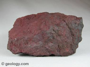
- Waypoint # 4 N48° 45.444 W91° 37.341
At this location you will find a large example of Hematite (Iron Ore). Hematite or iron ore weighs 5.15 grams per cubic centimeter or 5 150 kilograms per cubic meter.
- Your task is to calculate the weight in kg of this rock.
Step 1- Measure the length, height, and width (depth) of the rock. An estimate or best guess is fine. This will give you the volume of the rock.
Step 2- The density of Hematite is equal to 5 150 kg/m³.
Step 3 – Multiply the volume of the rock by its density. This will give you the approximate weight of the rock.
- Mandatory: Take an original photo of yourself, your group, or a personal item with the mural “The Spirit of the Miner/ Giving it all back” in the background. No need to show your face in the photo.
Found logs without the answers to the questions or the photo will be deleted. Please no spoiler photos. Enjoy your visit to Atikokan
References:
Downtown Atikokan - Self guided walking tour
https://www.cgs.ca/pdf/heritage/Rev5-CGA29-Steep_Rock-EN.pdf

| This cache placed by an Earthcache Master - Platinum level: |
 |