You will need to take 2 transparent bottles with you to GZ (plastic water bottles or similar). One of these will need a piece of string securely tied around its neck, about 2 metres long should do it.
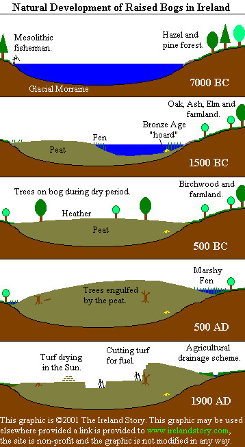
How a raised bog is formed
Raised bogs in Ireland began to form at the end of the Ice Age about 10,000 years ago. The glacial morraine left behind when the glaciers retreated created a hummocky and chaotic plain which had poor drainage. The depressions filled with water, creating thousands of tiny lakes. It was these tiny lakes that, over the 10 intervening millennia, have become the raised bogs.
The surrounding landscape would have been wooded with hazel and pine trees and at the edges of the lake, communities of reeds developed. These reed communities extended into the lake, depositing peat (poorly decomposed vegetable matter) on the lake bed. Over many years, this peat built up and up, choking the lake, until it began to emerge above the surface of the lake. Eventually only small areas of open water remained, as a consequence the water table rose until no water was running into the lake from surrounding land, and it stagnated. The peat and water thus became acidic, further preventing decomposition.
Thick cushions of bog-moss would have covered the mass of peat. At the edges of the bog, the wetter conditions allowed areas of stagnant water to develop, which allowed the bog to encroach upon, and bury, surrounding areas of woodland. With no decomposition of waste, the bog's dome continued to rise, becoming much higher than the surrounding landscape. This is where raised bogs get their name.
Carroll's Bog
Carroll's Bog. The Bog once constituted an extensive surface area in the vicinity of the junction of the Tramore River and Trabeg stream along the south east boundary of what is now the Tramore Valley Park. During the period of the Second World War attempts were made to cut turf from the bog for use as domestic fuel. This left characteristic water-filled trench-like scars across the bog and it provided an untamed natural environment with an eco-system attractive to a varied fauna. It acted as an ancillary reserve to the tidal mudflats of the Douglas estuary to the east of the bog, particularly for waterfowl, birds of prey and seasonal waders.
The Tramore River meandered its way in an easterly direction across the bog towards Douglas. During the 50 odd years until the 1980s the site was used as a landfill site and the river was realigned to flow south and then east paralleling the new N40, before again connecting with its former course near Douglas Village. Widened in section and leveed to provide greater storm water capacity and flood relief, the river lost most of its original natural character.
Recovery has gradually occurred as nature has taken its course and parts of the riverbank are now re-populated with native trees, shrubs and other vegetation which in turn has attracted wild birds once more. Fortunately, also, some important remnants of the original bog survive along the Trabeg tributary's course to the north and east of the park. Although nothing like its former natural glory, these habitats provide a basis for a healthy and diverse ecological resource, a fact recognised in the planning of the park.
Stage 1 This is the south end of the bog, the water has flowed through the bog and is about to join the other stream from stage 2 on its way to Douglas and beyond
Stage 2 of this earthcache is the stream at the western boundary of the park, in this case it is used as a control and has not flowed through the bog.
To log a find on this earthcache you need to carry out an experiment. Send me the results of your experiment and the answers to the questions through my profile by email or the message centre
You will need to take 2 transparent bottles with you to GZ (plastic water bottles or similar). One of these will need a piece of string securely tied around its neck, about 2 metres long should do it.
1. BE CAREFUL AT STAGE 1, THE LAST FEW METRES ARE BOGGY AND YOURE LIKELY TO GET (AT LEAST) WET FEET IF YOU DONT TAKE CARE. Fill a bottle with water from the stream at both stage 1 and stage 2, it’s at stage 1 you will need the bottle with string attached as it’s difficult to get to the water, throw the bottle in and haul it out once it’s full. The platform that looks like a viewing platform at stage 1 is for this very purpose, for monitoring the quality of the water. Retrieving water at Stage 2 is easy as you’re right at the water edge.
2a. Compare the water in the 2 bottles, is the water clear, muddy, cloudy, contains sediment, different colours? Have you fished out anything else in your bottles eg plant life, fish, solid matter, algae, tadpoles, an old boot etc.
b. Take these bottles home and let them settle overnight, then compare them again. Has anything sunk to the bottom or floated to the top. Has the colour changed.
3. Observe the conditions at both stages, what do see? Is the water flowing faster at one stage than the other, are they the same depth and width? Can you see signs of life in the water or at the waters edge at either stage, any plants growing in the water or on the banks, any birds you scared away, anything swimming in the water, ( if you fall in that doesn’t count) Why do you think they are different /similar.
4. At stage 1 the water has flowed through what’s left of the bog, do you think this has any baring in what you found in your bottle of water filled here, if so, in what way?
5. At stage 2 you will find a depth gauge, it’s on the square concrete structure, what is the reading on this gauge on the day of your visit.
6. Take a photo of the 2 bottles containing the water you retrieved, with your caching name showing clearly in the photo and post it to the cache page. Without this photo your find is not valid and will be deleted