Note: The answer for the question at Location 5 can be found within the AdLab text describing that location.
This is the Bonus Cache for the Decoding Dorchester Adventure Lab. The coordinates and finding hint for this cache will be revealed when you have completed the final stage of the AdLab.
Dorchester-on-Thames
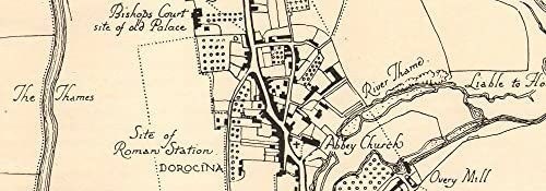
Nestling in the confluence of the Rivers Thames and Thame, Dorchester can trace its origins back to Neolithic times. To the south of the village can be seen the impressive remains of an Iron Age hill fort (Dyke Hills) while the area to the west is the site of a small Roman military town/garrison, known later as Dorocina (now allotments). The Roman road from Silchester (near Reading) to Alchester (north of Oxford) passed through the town while another Roman road came in from Henley (see F.J Malpas).
Dorchester played an important part in the development of Christianity in England during the Saxon period. In 634, Pope Honorius I sent Bishop Birinus to convert the Saxons of the local area to Christianity. King Cynegils of Wessex gave Dorchester to Birinus as the seat of a new Diocese of Dorchester, covering most of Wessex and Mercia. Cynegils was baptised in the River Thame by St.Birinus in 635. In the late 7th century the West Saxon bishopric was transferred briefly to Winchester, but by the late 9th century Dorchester again became the seat of the Mercian bishopric, when the Bishop of Leicester transferred his seat there. The diocese merged with that of Lindsey in 971, the bishop's seat moving to Lincoln in 1072.
The church of Dorchester Abbey as it stands today was built in about 1140 by Canons of the Augustinian order, although there are traces on the north side of Saxon masonry, probably part of an earlier cathedral which is thought to have occupied the site. King Henry VIII dissolved the Abbey in 1536, leaving the small village with a huge parish church. The Abbey is well worth a visit if you have time. Check here for details.
During the 17C and 18C, the village developed as a popular staging point for coaches passing between Oxford and Henley and several inns survive from that period; the Fleur de Lys, Crown, George, White Hart and what was formerly the Bull Inn but is now three houses. These are all timber-framed buildings, the carved brackets on the 'Bullyn' being of particular interest. These inns all have yards, the best being that of the George with its open gallery.
The bridge we see today (completed 1815) is situated about 100 yards north of an earlier bridge which led into the green at Bridge End and then on up into the village. It is said that the footings of the old bridge can still be seen when the river level is exceptionally low.
It is usually possible to find a space in the small (free) car park close to the bridge. Otherwise, kerb-side parking is permitted in sections of the main streets.
The final part of the walk can get muddy after rain.
To play the Adventure Lab, you will need the Adventure Lab app, available free for iOS and Android.
Tips on answering questions:
- Words are not case sensitive: "town", Town" and "TOWN" are all acceptable.
- Note whether a number should be entered as a numeral or as a word: "3" or "three".
- Where multiple words and/or numbers are required, omit any spaces: "1823townhall" not "1823 town hall".
To launch the AdLab on your smart-phone, scan the following QR code.

After completing the AdLab, you will need to scroll through to the final Journal entry to find the coordinates and finding hint for this Bonus Cache.
Congratulations to wendykmj on a very rapid FTF!