
Namib
🇩🇪
Die Ausdehnung der Namib beträgt von Norden (Benguela, Angola) nach Süden (bis zum Oranje; einigen Quellen nach auch darüber hinaus nach Südafrika hinein) rund 2000 Kilometer, sie reicht bis 160 Kilometer in das Land hinein. Die Namib ist etwa 95.000 km⊃2; groß und liegt im Mittel knapp 500 Meter über dem Meeresspiegel. Das als UNESCO-Welterbe eingestufte „Namib-Sandmeer“ hat eine Fläche von rund 31.000 km⊃2;, weitere 9.000 km⊃2; sind als Übergangszone (buffer zone) definiert.

In ihrem nördlichen Teil zum Grenzfluss Kunene hin bildet sie die als Schiffsfriedhof bekannte Skelettküste, wo zahlreiche Schiffsgerippe aus dem Sand ragen. Ihr mittlerer Abschnitt beherbergt mit Swakopmund und Walvis Bay zwei der wichtigsten Städte des Landes und den einzigen Tiefseehafen Namibias. Im Süden wiederum erstreckt sich auf etwa 500 Kilometern Länge das Diamantensperrgebiet um Lüderitz, in dem auch heute noch Edelsteine gewonnen werden. Der Schwerpunkt der Diamantenförderung hat sich jedoch an den Oranje und dessen Mündungsgebiet im Atlantik verlagert (Offshore-Abbau). Die Diamantengewinnung macht gut ein Drittel des namibischen Exporterlöses aus.
Bekannt ist die Namib für ihre Sanddünen, die, je nach Sonnenstand und Feuchtigkeitsgehalt, intensiv ihre Farben ändern. Zu nennen sind hier besonders die Dünen zwischen Swakopmund und Walvis Bay, die Düne 45 sowie die – häufig als höchste Dünen der Erde bezeichneten – Dünen beim Sossusvlei, etwa die Düne Big Daddy, die rund 380 Meter hoch ist. Die roten Dünen der südlichen Namib sind außer im Sossusvlei nur in den Tirasbergen, auf der Farm Gunsbewys, zugänglich.Die Ausdehnung der Namib beträgt von Norden (Benguela, Angola) nach Süden (bis zum Oranje; einigen Quellen nach auch darüber hinaus nach Südafrika hinein) rund 2000 Kilometer, sie reicht bis 160 Kilometer in das Land hinein. Die Namib ist etwa 95.000 km⊃2; groß und liegt im Mittel knapp 500 Meter über dem Meeresspiegel. Das als UNESCO-Welterbe eingestufte „Namib-Sandmeer“ hat eine Fläche von rund 31.000 km⊃2;, weitere 9.000 km⊃2; sind als Übergangszone (buffer zone) definiert.
In ihrem nördlichen Teil zum Grenzfluss Kunene hin bildet sie die als Schiffsfriedhof bekannte Skelettküste, wo zahlreiche Schiffsgerippe aus dem Sand ragen. Ihr mittlerer Abschnitt beherbergt mit Swakopmund und Walvis Bay zwei der wichtigsten Städte des Landes und den einzigen Tiefseehafen Namibias. Im Süden wiederum erstreckt sich auf etwa 500 Kilometern Länge das Diamantensperrgebiet um Lüderitz, in dem auch heute noch Edelsteine gewonnen werden. Der Schwerpunkt der Diamantenförderung hat sich jedoch an den Oranje und dessen Mündungsgebiet im Atlantik verlagert (Offshore-Abbau). Die Diamantengewinnung macht gut ein Drittel des namibischen Exporterlöses aus.
🇬🇧
The extension of the Namib from the north (Benguela, Angola) to the south (to the Orange; according to some sources, also beyond South Africa) is around 2000 kilometers, it extends up to 160 kilometers into the country. The Namib is about 95,000 km⊃2; and is on average just under 500 meters above sea level. The “Namib Sand Sea”, classified as a UNESCO World Heritage Site, has an area of around 31,000 km⊃2;, and a further 9,000 km⊃2; are defined as a buffer zone.

In its northern part towards the border river Kunene it forms the skeleton coast known as the ship cemetery, where numerous ship skeletons protrude from the sand. Its middle section is home to Swakopmund and Walvis Bay, two of the country's most important cities and the only deep-sea port in Namibia. In the south, on the other hand, the restricted diamond area around Lüderitz extends over a length of about 500 kilometers, where gemstones are still extracted today. However, the focus of diamond mining has shifted to the Orange River and its mouth in the Atlantic (offshore mining). Diamond mining accounts for a third of Namibian export earnings.
The Namib is known for its sand dunes, which change their colors intensely depending on the position of the sun and moisture content. The dunes between Swakopmund and Walvis Bay, dune 45 and the dunes at Sossusvlei - often referred to as the highest dunes on earth - such as the Big Daddy dune, which is around 380 meters high, should be mentioned here in particular. The red dunes of the southern Namib are only accessible in the Tiras Mountains, except in the Sossusvlei, on the Gunsbewys farm. The extension of the Namib is from north (Benguela, Angola) to south (to the Orange; according to some sources, even further into South Africa ) around 2000 kilometers, it extends up to 160 kilometers into the country. The Namib is about 95,000 km⊃2; and is on average just under 500 meters above sea level. The “Namib Sand Sea”, classified as a UNESCO World Heritage Site, has an area of around 31,000 km⊃2;, and a further 9,000 km⊃2; are defined as a buffer zone.
In its northern part towards the border river Kunene it forms the skeleton coast known as the ship cemetery, where numerous ship skeletons protrude from the sand. Its middle section is home to Swakopmund and Walvis Bay, two of the country's most important cities and the only deep-sea port in Namibia. In the south, on the other hand, the restricted diamond area around Lüderitz extends over a length of about 500 kilometers, where gemstones are still extracted today. However, the focus of diamond mining has shifted to the Orange River and its mouth in the Atlantic (offshore mining). Diamond mining accounts for a third of Namibian export earnings.
In der Geologie unterscheidet man Sande u.a. nach Ihrer Korngröße.
In geology a distinction is made between sands and others according to your grain size..
🇩🇪
Man spricht man von
- Feinsand (fS) (0,06 mm - 0,20 mm) gerade eben noch sichtbare Körner
- Mittelsand (mS) zwischen (0,20 mm - 0,63 mm) wie Grieß
- Grobsand (gS) (0,63 mm - 2,00 mm) 2 mm Durchmesser entspricht ein Streichholzkopf
Man erkennt unter der Lupe ihre weißliche, beige bis hellgraue Färbung, oft sind sie auch farblos oder durchsichtig. Ein Teil des Sandes besteht aus sogenannten Schwermineralien und eisenhaltigen Körnern, den Magnetiten. Je höher der Anteil der Schwermineralien ist, desto dunkler erscheint dann der Sand.
🇬🇧
One speaks of
- Fine sand (fS) (0.06 mm - 0.20 mm) grains just barely visible
- Medium sand (mS) between (0.20 mm - 0.63 mm) like semolina
- Coarse sand (gS) (0.63 mm - 2.00 mm) 2 mm in diameter corresponds to a match head
You can see their whitish, beige to light gray color under the magnifying glass, and they are often colorless or transparent. Part of the sand consists of so-called heavy minerals and iron-containing grains, the magnetites. The higher the proportion of heavy minerals, the darker the sand appears.
Bitte beantwortet folgende Fragen / Please answer the following questions:
Sand
a) Beschreibe den Tag, Uhrzeit und Wetterbedingungen während deines Besuches?
b) Beschreibe kurz die Farben und Formen der Quarz-Körner, die du erkennen kannst?
c) Beschreibe kurz die Farben und Formen der Schwermineral-Körner, die du erkennen kannst?
d) Befinden sich magnetische Körner in der Probe?
e) Wie hoch sind die prozentuellen Anteile der unterschiedlichen Sandkörner?
a) Describe the day, time and weather conditions during your visit?
b) Briefly describe the colors and shapes of the quartz grains that you can recognize?
c) Briefly describe the colors and shapes of the heavy mineral grains that you can recognize?
d) Are there magnetic grains in the sample?
e) What are the percentages of the different grains of sand?
🇩🇪
Natürlich kann man die Größe der der Sandkörner messen um festzustellen ob es sich um Feinsand, Mittelsand oder Grobsand handelt. Aber es gibt auch die Möglichkeit. Dazu braucht man ein Geodreieck oder ein Handy mit einer App womit man einen Winkel messen kann. Diese Aufgabe lässt sich am besten zu Hause mit einer getrockneten Sandprobe erledigen. Aber es geht auch vor Ort mit trockenem Sand. Last Sand aus der Hand locker auf den Boden rieseln bis einKegel entsteht. Je nach unterschiedliche Körnung, je mehr verschiedene Korngrößen vorhanden sind, umso größer ist der Schüttwinkel. Auch wird der Winkel durch die Feuchtigkeit in der Probe beeinflusst.....
🇬🇧
Of course you can measure the size of the sand grains to determine whether it is fine sand, medium sand or coarse sand. But there is also the possibility. You need a set square or a mobile phone with an app with which you can measure an angle. This task is best done at home with a dried sand sample. But it is also possible on site with dry sand. Loosely trickle the sand from your hand onto the floor until a cone forms. Depending on the different grain sizes, the more different grain sizes there are, the greater the angle of repose. The angle is also influenced by the moisture in the sample .....
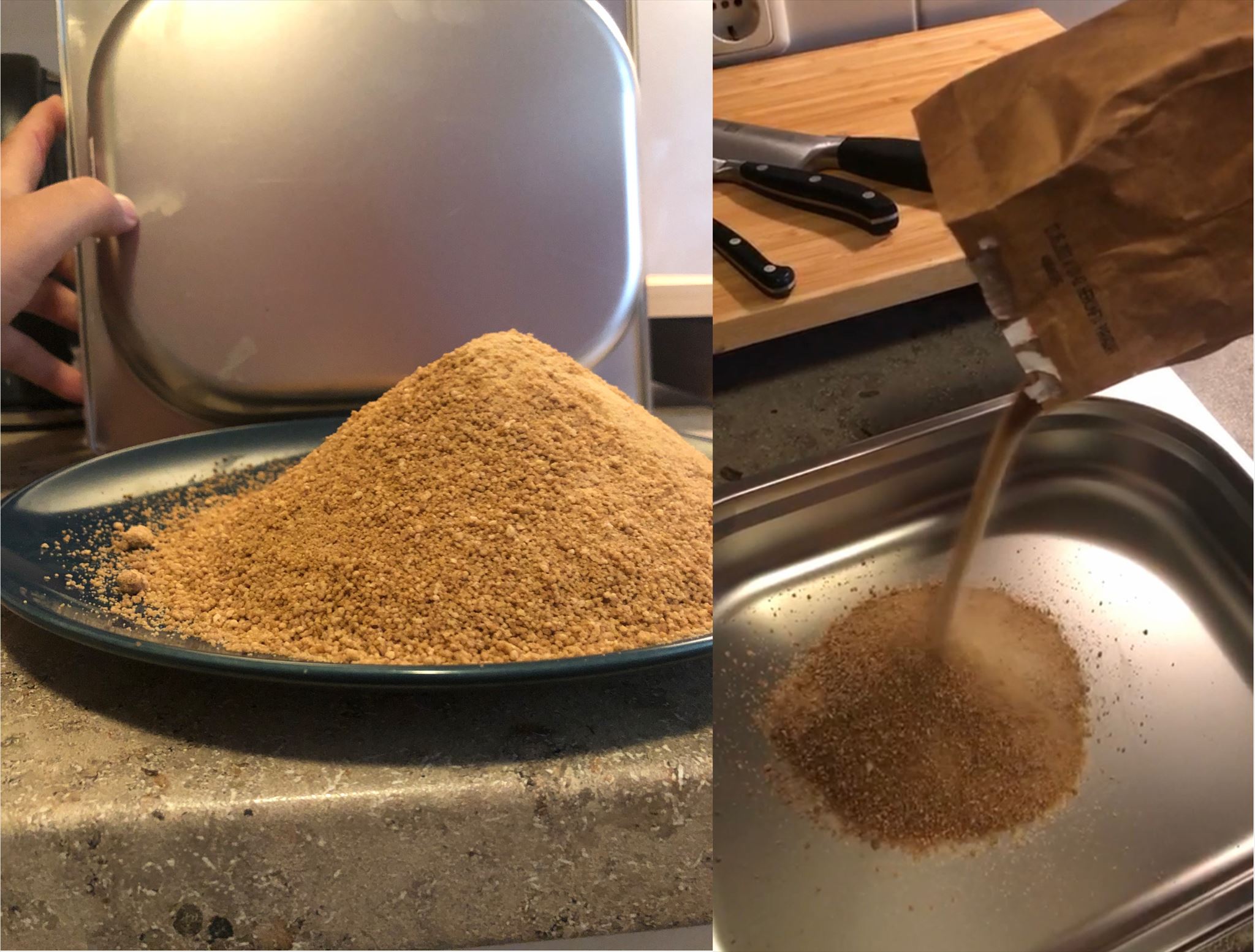
(Referenz: Brauner Zucker)
f) Ermittle den Schüttwinkel und schließe aus allen deinen Beobachtungen darauf, um welchen Sand (fein, mittel oder grob) es sich hier handelt?
f) Determine the angle of repose and deduce from all your observations which sand (fine, medium or coarse) is this?
Foto / photo

🇩🇪
Macht ein Bild von Dir / Euch oder eurem GPS mit dem der Düne 7 im Hintergrund, gemäß den Richtlinien eine Pflichtbedingung.... und ein Bild von eurem Experiment......
Um den Earthcache loggen zu dürfen, schreibt mir bitte eine Nachricht über mein Profil mit den Antworten.. Nach der Antwort könnt Ihr sofort loggen. Falls etwas nichts stimmt, melden ich mich!
Achtung - Bitte beachten!
Bitte schreibt die Antworten keinesfalls in Euren Log!
Logeinträge ohne Beantwortung der Fragen werden von mir ohne Nachfrage gelöscht!
Achtung: Je Account ist eine Antwortmail zu senden, um die Logbedingung zu erfüllen! Eine „Sammelantwortmail“ für mehrere Accounts erfüllt daher nur die Logbedingung für den jeweiligen Absender! Die Logs der anderen Accounts werden kommentarlos gelöscht!
🇬🇧
Take a picture of you or your GPS with the dune 7 in the background, a mandatory condition according to the guidelines ... and a picture of your experiment ......
In order to be able to log the Earthcache, please write me a message via my profile with the answers .. After the answer you can log in immediately. If something is wrong, I will contact you!
Attention - Please note!
Please do not enter the answer in your log!
Log entries without answers to the questions will be deleted without notice!
Please note: One reply email must be sent per account to fulfill the log requirement! A "collective reply email" for multiple accounts therefore only fulfills the log requirement for the respective sender! The logs of the other accounts will be deleted without notice!
Quellen / Sources:
https://de.wikipedia.org/wiki/Namib
https://en.wikipedia.org/wiki/Namib
https://de.wikipedia.org/wiki/Sand
https://en.wikipedia.org/wiki/Sand
https://de.wikipedia.org/wiki/Reibungswinkel
https://en.wikipedia.org/wiki/Angle_of_repose