
The Tuia Mātauranga Pōkai Whenua GeoTour follows the footsteps of early explorers of Aotearoa New Zealand taking you to places where leaders of the past searched for food, resources and ways to adapt and survive in this new land.
Use the Pōkai Whenua GeoTour as your classroom to explore the stories of the past, in the present, to preserve what is unique in Aotearoa New Zealand for the future.
Collect the codewords to get the Geocoin puzzle pieces.
To be able to complete this GeoTour and receive your special Geocoin collectable, remember to take a note of the codeword placed in the cache. This will need to be recorded in your passport which can be downloaded here .
63 of the 150 Pōkai Whenua GeoTour caches will contain a randomly placed special FTF token (a replica of the Tuia Mātauranga GeoTour commemorative coin). This is yours to keep! If you find more than one, you might consider leaving it for the next person who finds the cache.
Hamilton's gullies are a key landscape and natural feature within the city, occupying around 750 hectares or 8% of the city area. However, the gullies today don’t look how they did before European settlement in the area. Over time, as the city has expanded, the gullies’ natural features have been degraded and a large proportion of their native flora and fauna has been lost. These gullies provide green space for recreation, visual relief from the urban environment, and habitats for a wide range of wildlife. They are also a vital part of the city’s walkway and drainage systems. They have been protected since 1987, but prior to that many were partially filled in and neglected. Only around 1.6% of the original vegetation of Hamilton remains, much of it in these gullies. Restoring all of Hamilton's gullies could increase this figure to 8%, close to the 10% needed to support full biodiversity in an urban setting.
Why are the Gullies Important?
They contain significant areas of native vegetation and provide important green pathways for wildlife. The gullies also have cultural significance for Waikato iwi and contain heritage sites of historical and cultural importance. The gully streams are an essential part of Hamilton’s drainage network, channelling water from urban areas into the Waikato River. The quality of water within these streams is particularly important to the health of residents, wildlife and the food chain. They are used for a variety of outdoor activities and are important for their scenic values.
How are the Gullies being Protected?
Hamilton’s District Plan envisages a Green Network which links the city’s natural features into a continuous natural corridor and, over time, restores them. The idea of this green corridor is to increase the variety of indigenous species in the city, and to improve the natural environment that supports the city.
Many of these gullies are in private ownership. As well as providing rules through the District Plan to control aspects of development around gullies, the Council and community are using other methods to look after and improve the gully systems, such as:
1. Restoring and replanting gullies in conjunction with the Community Planting Programme
2. Providing information and education to increase public awareness and understanding of environmental issues
3. Controlling weeds and pests on Council land
4. Developing gully management plans
5. Funding the purchase of gullies as reserves
Other community initiatives such as the gully register project, aims to identify and monitor restorations taking place in the city’s gullies and is an important part of measuring progress towards restoring indigenous biodiversity back to Hamilton. As at October 2003 some 187 hectares were under restoration including 142 ha on public land and 45 ha on private land.
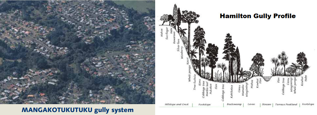
The MANGAKOTUKUTUKU gully system is one of 4 major gully systems within Hamilton. This gully is home to a variety of native wildlife including birds, bats, lizards and invertebrates. The stream supports several native fish species, some of which are considered threatened (eg Giant kokopu, longfin eel and mudfish). This geotour cache is placed in Sandford Park, a reserve within the gully system. The Sanford Park stream and wetland restoration project was created to showcase what can be achieved through restoration of streams flowing through urban centres. Like all the Hamilton gullies, the health of the Mangakotukutuku has over time been affected by human activity, and historically large areas of the gully were cleared allowing weeds to take over. The water and habitat quality in the stream is affected by bank erosion, farming activities in the upper catchment, and stormwater discharges from urban areas. The project aimed to address these issues, by providing stabilising vegetation on the banks, and creation of habitat features for native fish in the streams. The project also introduced a new wetland habitat to Sandford Park.
The cache is NOT at the posted coordinates.
The posted coordinates will take you to a sign at one of the entrances to Sandford Park. Read the sign and answer the questions below to get the coordinates for the Final. There is no parking on Peacockes Rd, so we suggest parking at the Fitzroy Ave entrance (S37 48.825 E175 17.900).
The cache can be found at S37 48.ABC E175 17.DEF where:
A = The last digit in the year of the “before” photo.
B = The number of images that feature people.
C = The last digit of the year the Mangakotukutuku Stream Care Group was established.
D = The sum of the digits in the year that mudfish were released into the wetland.
E = The sum of the digits in the “after” photo.
F = What creature was the Condo created for? Number of letters -1.
Checksum: A+B+C+D+E+F = 35
The cache is hidden along the reserve walkway in our take on a Tuna Townhouse (but well above stream level – no need to go near the stream).
In keeping with the conservation theme of this Geotour, all our caches and logbooks are made of recycled materials, or items we had on hand already.