Im Urlaub 2020 habe ich diesen Canyon besucht und fand,
dass die geologischen Besonderheiten einen EarthCache wert sind.
Bei der Erarbeitung des Listings hat mich GeoawareDE10 mit seinem
Fachwissen unterstützt, wofür ich mich sehr herzlich bedanke!
!-! ACHTUNG !-!
Bei der Besichtigung des Canyons war alles trocken -
bei oder nach Regen oder bei einem aufziehendem Unwetter
sollte auf den Besuch des Canyons verzichtet werden!
!-! ACHTUNG !-!
Die Insel Rhodos besteht aus Sedimenten, die sich auch auf dem
griechischen Festland finden.
Sie ist keine Vulkaninsel – sondern nur deshalb eine Insel, da seit dem
letzten Höchststand der vergangenen Eiszeit der Meeresspiegel
um über 100 Meter angestiegen ist.
Geologisch interessant ist die Insel, da man auf ihr reichliche,
marine Tertiärfossilien finden kann - genauer gesagt, oberes
Pliozän bis beginnende Pleistozän.
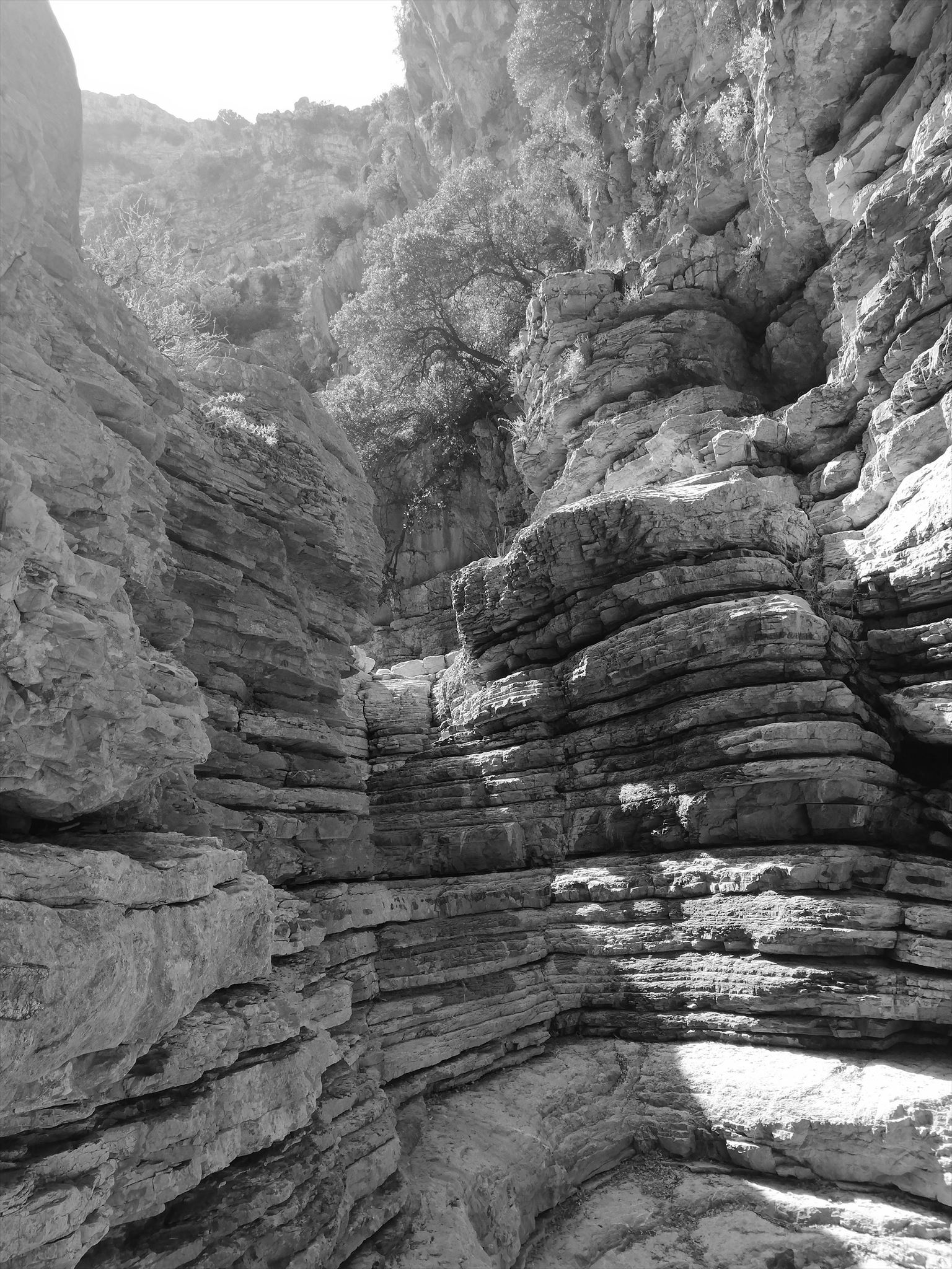
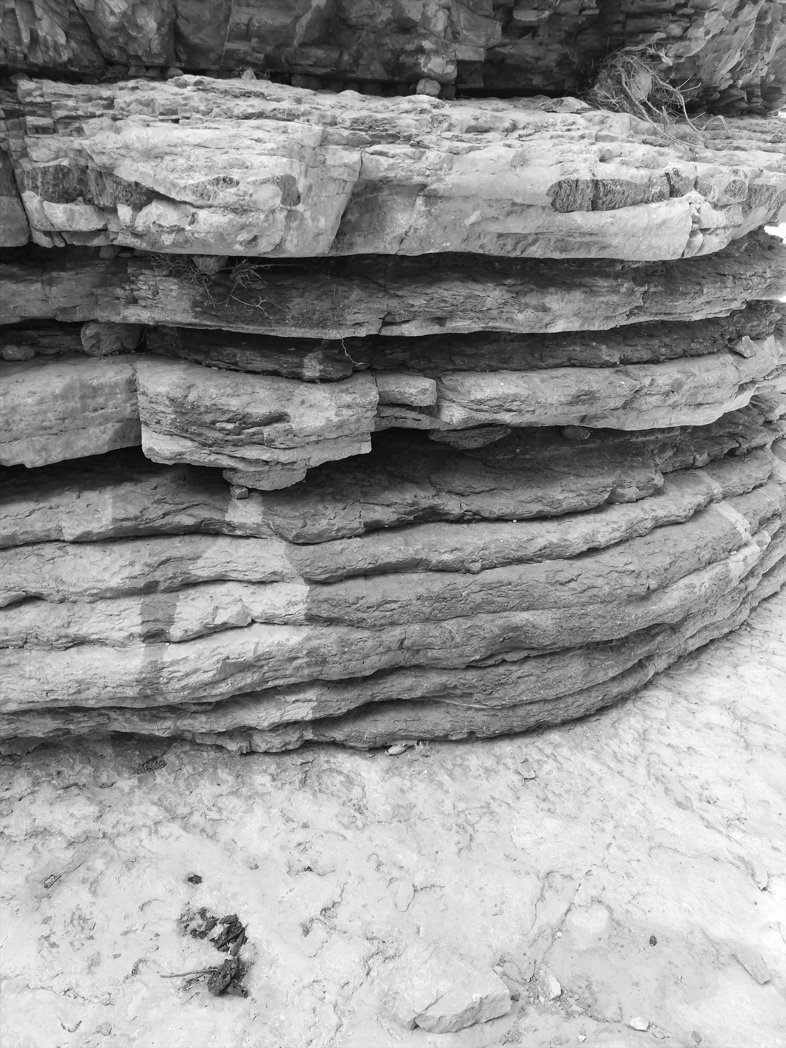
Die vor Ort erkennbaren, aufgeschlossenen Gesteinsschichten bestehen
aus dunklen Mergel- und hellen Sandabfolgen mit Schotterbänken.
Nur die Mergel und Sande des unteren Bereiches sind fossilführend.
Schichtmächtigkeiten von wenigen Metern bis hin zu fast 200 Meter Höhe.
Sandstein und Mergel, (fein)geschichtet, im unteren Bereich; durch
feinverteilten Hämatit gefärbt.
Diese oxydische Eisenverbindungen von Hämatit (Fe2O3) und
Limonit (FeOOH) sind für die Farbe des Gesteins verantwortlich.
Durch die Zersetzung entstehen um die organischen Partikel herum
sogenannte Reduktionshöfe, innerhalb derer das Gestein gebleicht wird.
Innerhalb der Reduktionshöfe wird das dreiwertige Eisen in seine
wasserlösliche zweiwertige Form über- und mit dem Wasser abgeführt
und das Gestein somit entfärbt.
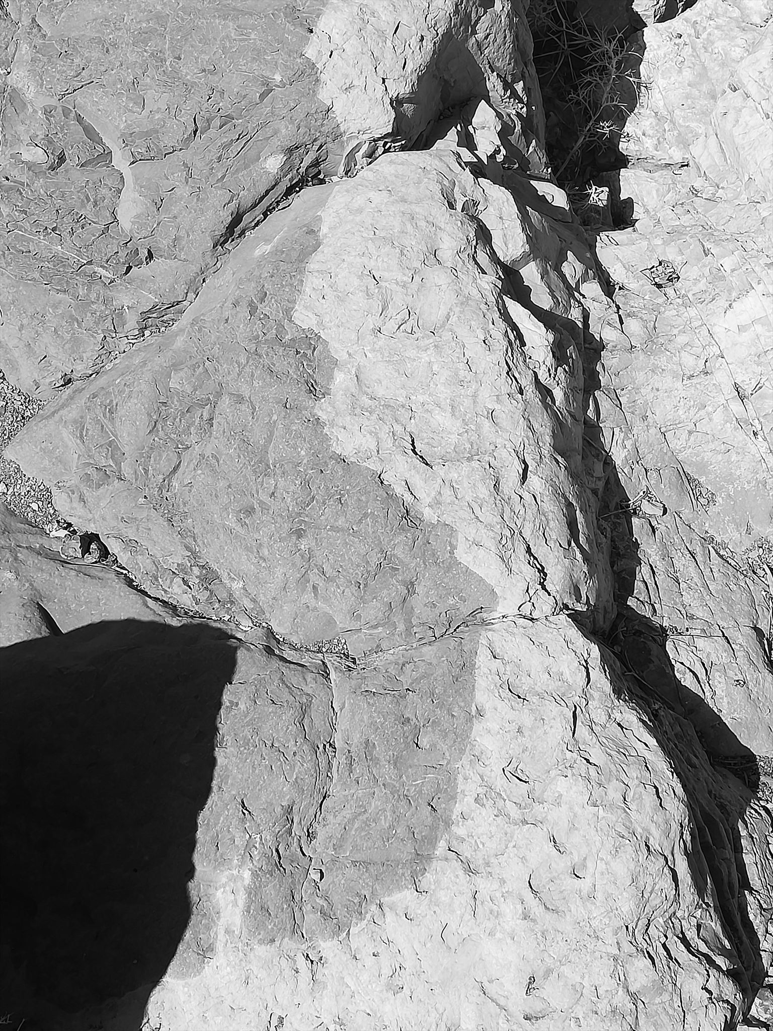
Solche Bleichungszonen können einen Durchmesser von wenigen
Millimetern, aber auch einigen Zentimetern erreichen.
Die Bleichung in den Gesteine sind an bestimmte Schichten gebunden,
da dort ursprünglich ein höherer Anteil an organischen Partikel war;
aber auch sekundär durch Verwitterung, mit dem Wasser abgeführt,
über die Schichtgrenzen hinweg entfärbt.
Je nach Bindemittel der Körner im Gestein, verwittert dieses
unterschiedlich. Dadurch stehen manche Schichten mehr als andere
aus der Felswand heraus.
Kennzeichnendes Merkmal aller Sedimentgesteine ist die Schichtung.
Sie entsteht durch Änderung in den Sedimentationsbedingungen,
z.B. der Zufuhr von stofflich unterschiedlichem Detritus oder dem Wechsel
der Korngröße der sich absetzenden Substanzen.
Die vor Ort zu erkennenden Sandsteinfolgen weisen eine Bankung auf,
welche auf wiederholte Sedimentationsunterbrechungen zurückzuführen ist.
Quelle: https://www.zobodat.at/pdf/JahrbGBA-SB_01_0001-0255.pdf
Beantwortet folgende Fragen um den EC loggen zu dürfen:
A: Von der Brücke aus siehst du links eine hohe Wand mit vielen Schichtungen.
Nenne mir die Anzahl derer bis zu einer Höhe von 20 Metern.
B: Gehe in den Canyon bis es nicht mehr weiter geht!
Auch hier findest Du viele Schichtungen.
Wie stark sind diese durchschnittlich? Antwort in Zentimetern (ca.)!
C: Im vorderen Bereich sind einige Felsen großflächig eingefärbt.
Welche Farbe hat die Verfärbung?
D: (optional) Mache ein Bild im Canyon und stelle es dazu!
Bitte achte darauf, dass du die Antworten (Bild) nicht spoilerst!
Die Antworten können mir sowohl über das eMail-Kontaktformular als auch über
den Messenger geschickt werden, loggen kann man dann sofort.
English:
On vacation 2020 I visited this canyon and found
that the geological features are worth an EarthCache.
When working out the listing, GeoawareDE10 asked me with his
Expertise supported, for which I thank you very much!
!-! DANGER !-!
When visiting the canyon, everything was dry -
during or after rain or an approaching storm
a visit to the canyon should be avoided!
!-! DANGER !-!
The island of Rhodes consists of sediments that are also on the Find
mainland Greece. It is not a volcanic island - just an island because
since then last high of the past ice age sea levelhas
increased by over 100 meters.
The island is geologically interesting as there are plenty of
marine tertiary fossils - more precisely, upper one
Pliocene to early Pleistocene.
The exposed rock layers that are recognizable on site exist
from dark marl and light sand sequences with gravel banks.
Only the marl and sands of the lower area are fossil-bearing.
Layer thicknesses from a few meters to almost 200 meters in height.
Sandstone and marl, (finely) stratified, in the lower area; by
finely divided hematite colored.
These oxidic iron compounds of hematite (Fe2O3) and
Limonite (FeOOH) are responsible for the color of the rock.
The decomposition creates around the organic particles
so-called reduction yards, within which the rock is bleached.
Within the reduction zones the trivalent iron is in his
water-soluble divalent form over and removed with the water
and the rock thus discolored.
Such bleaching zones can be a few in diameter
Millimeters, but also a few centimeters.
The bleaching in the rocks are tied to certain layers,
since there was originally a higher proportion of organic particles;
but also secondary by weathering, carried away with the water,
discolored across the layer boundaries.
Depending on the binding agent of the grains in the rock, it will weather
differently. As a result, some layers stand more than others
out of the rock face.
Stratification is a distinguishing feature of all sedimentary rocks.
It arises from a change in the sedimentation conditions,
e.g. the supply of materially different detritus or the change
the grain size of the settling substances.
The sandstone sequences to be recognized on site have a bank,
which is due to repeated sedimentation interruptions.
Source: https://www.zobodat.at/pdf/jahrbGBA-SB_01_0001-0255.pdf
Answers the following questions to be able to log the EC:
A: From the bridge you can see a high wall with many layers on the left.
Tell me the number of them up to a height of 20 meters.
B: Go into the canyon until you can't go any further!
You will also find many layers here. How strong are these on average?
Answer in centimeters (approx.)!
C: In the front area, some rocks are extensively colored.
What color is the discoloration?
D: (optional) Take a picture in the canyon and add it!
Please be careful not to spoil (Picture) the answers!
The answers can be sent to me both via the email contact form and via
the messenger, you can log in immediately.
Viel Spaß beim Erkunden des EC

Have fun exploring the EC