The Tuia Mātauranga Pōkai Whenua GeoTour follows the footsteps of early explorers of Aotearoa New Zealand taking you to places where leaders of the past searched for food, resources and ways to adapt and survive in this new land.
Use the Pōkai Whenua GeoTour as your classroom to explore the stories of the past, in the present, to preserve what is unique in Aotearoa New Zealand for the future.
Collect the codewords to get the Geocoin puzzle pieces
To be able to complete this GeoTour and receive your special Geocoin collectable, remember to take a note of the codeword placed in the cache. This will need to be recorded in your passport which can be downloaded here.
63 of the 150 Pōkai Whenua GeoTour caches will contain a randomly placed special FTF token (a replica of the Tuia Mātauranga GeoTour commemorative coin). This is yours to keep! If you find more than one, you might consider leaving it for the next person who finds the cache.
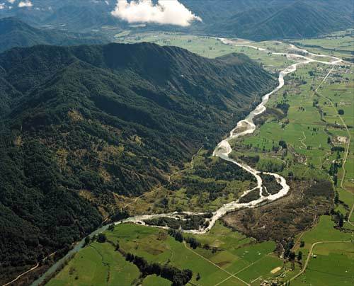
The discovery of gold and the search for grazing land were the initial driving forces behind the establishment of the township of Hampden, which later became known as Murchison. But developing a settlement in wild, inhospitable, isolated country was slow.
Māori axes and implements indicate that Māori passed through the area in pre-European times on their way to and from the West Coast for its valuable pounamu. The dense native forest in the Upper Buller provided excellent hunting for birds, but it seems that Māori did not live in the area.
Located on the Four River Plain at the confluence of the Buller, Matakitaki, Mangles and Matiri Rivers, the heavily wooded flat was first described by Charles Heaphy. In February 1846, each carrying a 75 lb pack, Heaphy, Thomas Brunner, William Fox using the expertise of their Māori guide, Kehu (Ngāti Tumatakokiri) set off from Nelson to look for ‘the plain beyond Rotoiti. Heaphy wrote of their first sighting of the Murchison Valley: “an expanse of open manuka country, with pine (kahikatea) forests and fern flats on either side of the Buller, several valleys seem to join the main opening a mile or two down the plain.”
Further surveys were conducted in 1859 by John and James Rochfort, who travelled up the Buller River from Westport in kayaks, reaching four miles above Lyell before their canoes capsized in rapids and they returned by foot to Westport. Early in 1860, James Mackay and Julius von Haast suffered severe privation when they conducted a survey in the area. Haast named Mount Murchison after noted British geologist, Sir Roderick Murchison.
Shaky Ground
For centuries before Europeans arrived, Māori had experienced rū whenua - ‘the shaking of the land'. According to Māori tradition, earthquakes are caused by the god Rūaumoko (or Rūamoko), the son of Ranginui (the Sky) and his wife Papatūānuku (the Earth).
Rangi was separated from Papa, and his tears flooded the land. Their sons resolved to turn their mother downwards, so that she and Rangi should not constantly see one another's sorrow.
When Papatūānuku was turned over, Rūaumoko was still at her breast, and was carried to the world below. To keep him warm, he was given fire-he is the god of earthquakes and volcanoes, and earthquakes are caused by him twisting and turning about.
Murchison earthquake
On 17 June 1929, at 10.17 a.m., a magnitude 7.8 earthquake struck the northern South Island. It was felt in cities and towns all over New Zealand. Nelson, Westport and Greymouth reported damage, but it was half a day before authorities realised that the worst hit region was Murchison.
For days preceding the earthquake, booming noises had been heard in the hills around Murchison. The earthquake itself was exceptionally noisy: rumblings were heard in New Plymouth, over 250 kilometres away. It was caused by movement along the White Creek Fault west of Murchison. Land moved upward as much as 4.5 metres along the fault.
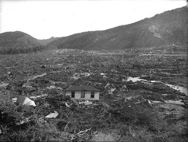
When the main shock struck, wooden homes warped, twisted and shifted from their piles, and chimneys and water tanks collapsed. People scrambled outdoors, but once there found they were unable to stand.
Landslides
The shaking triggered dozens of huge slips on the steep mountain slopes, which were waterlogged from winter rain. Landslides blocked many rivers, including the Matiri, Maruia, Mōkihinui and Buller. The landslide dam on the Mōkihinui River later burst; the resulting flood seriously damaged Seddonville.
A massive landslide swept over the Busch and Morel homes, killing four people and damming the Mātakitaki River. The slip blocked the river, and a lake extended almost 5 kilometres upstream until a flood in the 1930s, when the river carved a new path through the landslide. The rough topography of the landslide is too difficult to clear for farming.
In the Maruia valley a landslide pushed the Gibson home across a road and into a gorge, killing three people. Another swept the Holman home into the river, killing two. Of the 17 people who died in the earthquake, 14 were killed by landslides, and 2 in coal mine collapses.
The aftermath
With their homes uninhabitable and aftershocks continuing, residents camped in the open, or in sheds and tents. Communal kitchens were set up, but food supplies ran low. The landslide-dammed rivers posed a danger of flooding, so over several days most people left Murchison. They travelled part of the way in cars, then continued on foot, negotiating slips and streams. They eventually reached Glenhope, where they caught trains to Nelson.
Nelson, Greymouth and Westport had many damaged chimneys and brick buildings – the tower of Nelson Boys’ College collapsed, injuring two boys. In Karamea, damage was minor but numerous slips blocked the coastal road and food ran short. No outside help arrived until an aviator landed a Tiger Moth plane on the beach two weeks later. Vehicles could not reach the town for several months.
In an era when road work was carried out with pick and shovel, many roads buried by slips in the Buller region did not re-open for months. The Westport to Reefton road was closed for 18 months.
Busch’s Slip
Evidence of the seismic power of the earthquake at the end of Johnson Creek Track (see GC2AG7V Murchison 1929 Earthquake Earthcache). Huge layered sedimentary rocks are jumbled about below the cliff face from which they were sheared in 1929. Native forest is regenerating around the massive rocks which have been eroded and weathered.
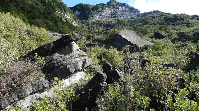
Johnson Creek Track
The Cache
The cache is 4-5 kms along a mainly gravel road, your town car will be able to get there and overlooks the start of the Earthquake Rapid which is popular amongst experienced kayakers, graded as class III during normal river flows and rise to the more difficult class IV at higher water levels. There is room to pull off the road and turn around here