The cache is not at the listed coordinates!
This BONUS physical cache is associated with the Adventure Lab "Hiking Spokane". You must complete all five stages of the associated Adventure Lab to learn the location of this cache.
To complete the Adventure, you must visit 5 locations and answer a question correctly at each stop. The Adventure Journal will include a hint for each correctly answered question. Taken together, they will provide you with the final coordinates to the bonus cache.
Here is the formula for the bonus cache: N 47* 34.ABC W 117* 17.DE1
Welcome to Iller Creek Conservation Area, Rocks of Sharon, Big Rock, Tower Mountain or Krell Mountain, whatever you choose to call it. This area has many names, but it all means just one thing; lots of fun!
This area is part of the Dishman Hills Conservation Area. The Dishman Hills is comprised of three units of land that are open to the public: the Dishman Hills Natural Area, Glenrose, and Iller Creek. There are also about 500 acres of the Dishman Hills, including the newly-acquired Wilson Conservation Area, that are not yet open to the public, as there is no legal access, parking, or trail systems yet.
The Iller Creek Unit of Dishman Hills Conservation Area consists of 966 acres of County-owned, preserved open space. Together with Dishman Hills Conservancy-owned property, 1,233 acres of scenic, high quality habitat is available for hiking, biking, rock climbing and snowshoeing. While the DHCA currently consists of two separate areas in the Glenrose and Iller Creek areas, a long-term vision is emerging that could eventually connect the two areas and Dishman Hills Natural Area to create a large wilderness-like area within 5 miles of downtown Spokane.
Iller Creek boasts a wonderful five-mile loop consisting of lush shaded forest and a ridgeline ramble with outstanding views of the Washington Palouse to the South and the Selkirks to the North and East. In the middle of the hike one reaches the Big Rocks (Rocks of Sharon), one of the best rock climbing destinations in the area. Here you will find expansive views of the surrounding scenery and towering rock formations. You can see the Palouse stretched out at your feet, and even Steptoe Butte in the distance. Keep your eyes open and you may see deer, moose, elk, bears, coyotes, many species of birds and other forms of wildlife, as well as many varieties of wildflowers.
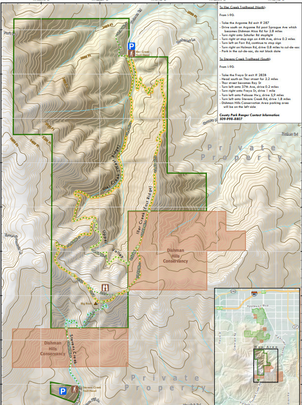
There are 2 trailheads to this area: Iller Creek Trailhead to the north and Stevens Creek Trailhead to the south. When I first discovered this place, the trail system encompassed the very top ridgeline, where all the towers are. Since then it has been closed, due to private property. They're trying to obtain access to the trails again, but I wouldn't hold my breath. So sad!
Coordinates for the northern Iller Creek Trailhead are: N 47° 36.103 W 117° 16.908
QR CODE FOR "HIKING SPOKANE" ADVENTURE LAB CACHES:

MAP OF ILLER CREEK CONSERVATION AREA: