The Tuia Mātauranga Pōkai Whenua GeoTour follows the footsteps of early explorers of Aotearoa New Zealand taking you to places where leaders of the past searched for food, resources and ways to adapt and survive in this new land.
Use the Pōkai Whenua GeoTour as your classroom to explore the stories of the past, in the present, to preserve what is unique in Aotearoa New Zealand for the future.
Collect the codewords to get the Geocoin puzzle pieces
To be able to complete this GeoTour and receive your special Geocoin collectable, remember to take a note of the codeword placed in the cache. This will need to be recorded in your passport which can be downloaded here.
63 of the 150 Pōkai Whenua GeoTour caches will contain a randomly placed special FTF token (a replica of the Tuia Mātauranga GeoTour commemorative coin). This is yours to keep! If you find more than one, you might consider leaving it for the next person who finds the cache.
Pā sites are fortified settlements with defensive terraces and palisade walls. They are more commonly seen in the North Island, but several prominent pā sites can be seen on the east coast of the South Island. During the early period of occupation Māori lived in villages and open settlements, but as the population grew iwi settled areas and territorial boundaries were established. Inter-tribal conflict, and the desire for resources, lead to warfare and an increased risk of invasion. This necessitated a new style of settlement, strong and defensible, in order to protect village inhabitants, food and other valuable resources.
Te Kohanga o Kaikai-a-Waro Pā is believed to be the earliest known pā in the South Island. The discovery of the pā came as a surprise to the team of archaeologists who excavated the area in preparation for the construction of the Pegasus township. Excavations for the golf course revealed a large number of artefacts and archaeological features (Figure 1). A series of postholes were exposed, 37 of which were discovered in a 50 m long line. Some of the postholes contained the remains of wooden posts as well as adzes and pieces of greenstone.
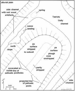
Figure 1: Features surrounding the pā site
Midden (food refuse) was discovered on the north-eastern side of the channel. The midden contained various types of shellfish, dog, rat, fish and bird bone. Thousands of artefacts were recovered including stone tools made from chert, pounamu, obsidian and silcrete, and bone artefacts such as needles and ornaments. A probable waka (canoe) landing site was also identified on the edge of the channel.
Excavations in the channel exposed some truly amazing finds. Rarely seen wooden artefacts were uncovered in perfectly preserved condition including an adze handle, part of a canoe, patu, digging sticks, a spinning top and half of a manaia carving on a plank. These types of artefacts rarely survive in the archaeological record, but it seems that the inhabitants of the pā placed these items in the channel where they were preserved by the watery environment. Approximately 750 wooden items were recovered from the channel, a remarkable number.
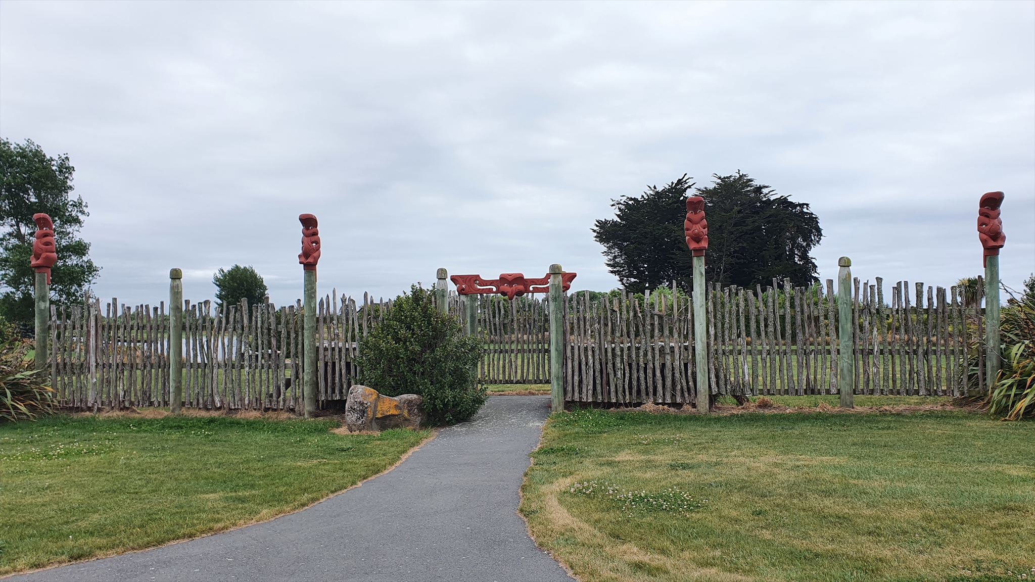
Figure 2: The reconstructed palisade wall
What can you see?
At GZ there is a reconstruction of the palisade wall that would have acted as the entry point to the pā (Figure 2). This wall has been modelled on the row of postholes uncovered during the excavation. Large boulders can also be seen about the site, these mark the locations where kōiwi (human remains) were recovered. The waka landing site can also be seen down by the channel behind the seats within the pā.
The cache is a crafty wee hide. It can be reached from either side and can be lifted or pulled out. Please remember to replace and hide as found.